
Earlier this year, I had business reasons to be in northern Idaho. I live in southern Idaho and prefer flying a direct route that gets me to my destination in two hours and 15 minutes. The day of my departure, however, Airmet Sierra was in effect and the mountains were obscured. I had two options: I could see if I could get on top and fly to the clear areas on the other side of the mountains, or I could take the much longer valley route that would keep me below the ceilings.
I chose the on-top alternative. The valley alternative would require at least four hours of flying, which means a fuel stop to stay within my personal fuel minimums, and potentially a bit of routing through Hells Canyon along the Idaho/Oregon border to avoid high terrain. It would also result in a night arrival into an airport in the bottom of a narrow valley.
The day of my departure, I had one good sign. The area forecast predicted tops at between 12,000-14,000 feet. That’s a familiar forecast for the time of year, and I find it enjoyable to fly over a cotton-like cloud deck. It was also well within my airplane’s capability, and I had a four-place oxygen bottle that had been recently topped off. Looking at the satellite data, Metars and TAFs at my destination, it appeared to be clear on the far end of my route. If I could find a hole above and maintain my cloud clearances, I could get on top, fly with my O2 and reach my destination in 0215 instead of four-plus hours and a fuel stop.
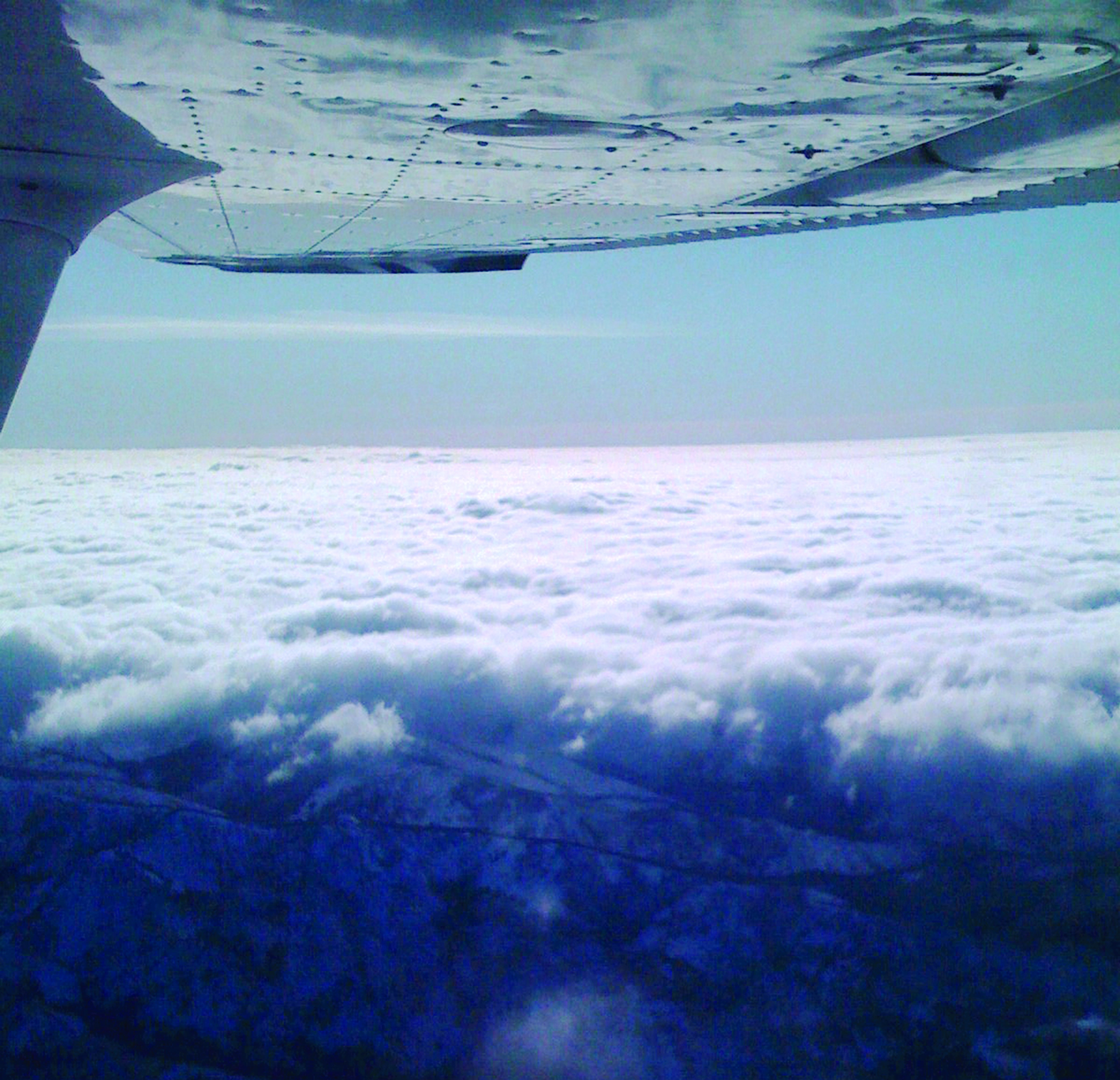
Not too long after takeoff, I found a decent sucker hole above me that allowed me to spiral-climb up to take a peek. At first, it looked like I might make it, but as I proceeded, the tops kept climbing. When I got to 17,000 feet, it became obvious the tops were not at the 12,000-14,000 feet predicted, and my plan was not going to work. I did a 180 back to my sucker hole and descended for the alternative four-hour flight, where I stayed mostly around 8500 feet but remained in the valleys.
Sometimes you are better off not getting sucked in by the sucker hole and taking the long way.
Two Different Operations
Poking up through a cloud deck feels like freedom, like the feeling of scooting into a wide-open lane on a jammed-up freeway. Once above the clouds, there is nothing better than the feeling of punching direct on the GPS and making a straight-line route over the top of all that craziness below. That being said, having the freedom to do something doesn’t mean you should.
From the FAA’s perspective, there are two legal ways to fly above a solid cloud deck. If you depart and land in VFR conditions, and can maintain VFR cloud clearances while over the top of a cloud deck, you can fly “VFR over the top.” This isn’t a clearance because, with a few exceptions, you don’t need a clearance to fly VFR. In this case, VFR over the top is just a phrase describing the practice.
If you are on an IFR flight plan and are above the clouds, you can request and receive a “VFR on top” clearance. This entitles you to remain on your IFR flight plan, but you can fly at VFR altitudes while remaining in VFR conditions.
Both of these ways of flying on top are essentially the same behavior—you follow VFR rules and cloud clearances and must remain in VFR conditions at all times. Meanwhile, the “VFR on top” IFR clearance is a specific, approved operation. Again, you don’t need a clearance or even a VFR flight plan to fly VFR over the top, but flight following is always a good idea, doubly so when flying VFR over the top.
Where are the Tops, Anyway?
There are three basic weather products that help pilots identify where the tops are: area forecasts, radar summary charts and Pireps (pilot reports). Beyond these three basics, you may have to become increasingly clever.
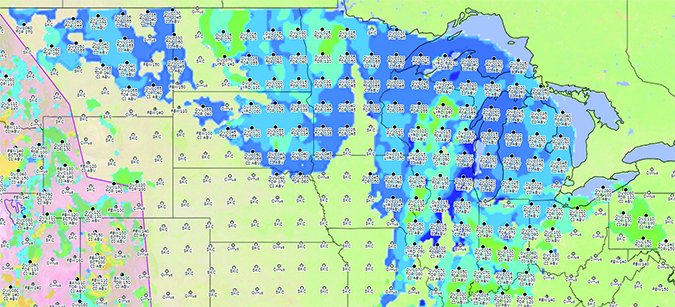
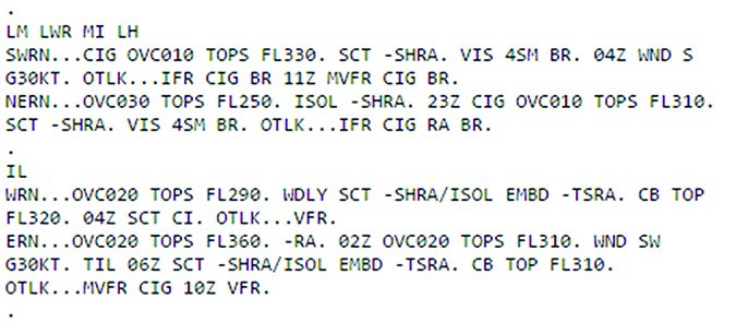
The first place I look for cloud tops is in the area forecast, coded FA, which is part of a standard weather briefing. (Note that the FA is being discontinued in the U.S. by the National Weather Service. The latest news is that FA products for the continental U.S. and Hawaii are scheduled to no longer be available the end of 2016. The presently experimental graphic area forecast depicted here is a likely replacement. Area forecasts will continue to be issued for Alaska, the Caribbean and the Gulf of Mexico.)
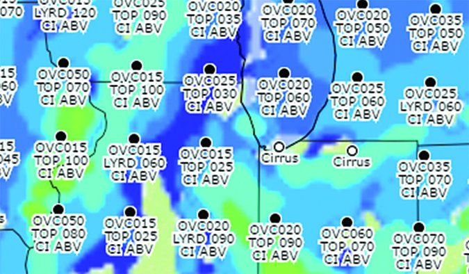
The FA and the planned replacement graphical products provide predicted cloud tops with cloud and weather data, and all are valid for a period specified in the forecast. The downside of FA predictions is they are very general, as the name implies, and cover a wide area like half of a state or even multiple states.
Once you have a sense of where the tops will be, you should take a look at the freezing levels and icing forecasts. The layers below you are not created equal, with some much more dangerous than others. Use weather data to evaluate the degree of risk posed by the clouds below. It should always be a part of your decision making to get on top.
The second most useful place to find cloud tops is on the radar summary graphic. This chart often includes tops, but in my experience, the tops shown are typically for those larger, precipitation-producing systems that an average piston-engine pilot has no chance of climbing above.
Pireps are great when you can find enough of them to paint a picture. Unfortunately, they often are few and far between. But every now and again, one gets lucky, and a pilot either at or near the destination airport or somewhere along the route reports bases and tops.
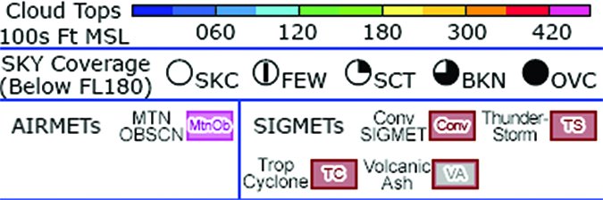
Shown at right are screenshots of the NWS’s experimental graphic area forecast, its legend and an excerpt from a text-based FA.
The Downsides
The biggest downside of flying over a deck of clouds is obvious: You cannot see the ground. Compared with flying in actual instrument meteorological conditions (IMC), VFR on top can be much easier and safer. The best choice of action always depends on the terrain, the airplane and the mission. Most of the time when flying VFR on top, I have a horizon and don’t need an intensive IFR instrument scan to keep the wings level. It is quite relaxing compared with hand-flying the plane in actual IMC.
As an IFR pilot on top, I have a wide range of emergency options. All I need is an airport that has reasonable ceilings and visibilities for an instrument approach through the soup. In the event of an emergency descent or unplanned landing en route, instrument-rated pilots also have the potential convenience of briefing their approach to an airport while above the clouds.
For VFR pilots, flying VFR over the top is often not substantially different than flying in regular VFR, except for having fewer options if things go wrong. You must still maintain cloud clearance. If you are flying between layers—and if the undercast is uneven—there can be some optical illusions that make it tricky to keep the wings and the nose level, but generally it’s not that different from any other cross-country flight.
Of course, there’s an enhanced risk when not operating IFR and VMC conditions can’t be maintained above a cloud deck. Once on top, you are stuck there until you find a way down. Sometimes, the weather doesn’t cooperate. Nearly every year, the National Air Traffic Controllers Association gives at least one award to a controller who talked a VFR pilot stranded on top through the clag and back to the ground.
Just because it is clear at the destination, and you are comfortable on top at the beginning of the trip, doesn’t mean the layer you are over will remain unblocked. It is not uncommon for the tops to climb or to be punctuated by buildup that can become an impenetrable wall of clouds that exceed your ability to climb or your aircraft’s service ceiling.
Another trap is the layer above coming down to join the layer you are over. This convergence of layers can pinch out the VFR option. When this happens to IFR pilots, it is time for a pop-up clearance (assuming there’s no ice in there). When I am considering a route on top or over the top, I always make sure I know the freezing level, and I like to have an IFR clearance on file that I can pick up for the asking should I need it.
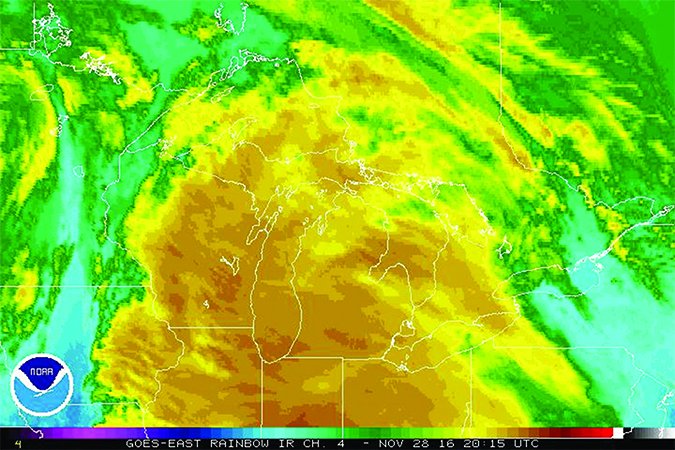
Finding Tops with Science: IR Satellite Extrapolation and Soundings
If you want to find the tops and are ready to do some light science, one approach is to look up a satellite image with infrared data showing the temperatures, an example of which is at top right. Compare the IR temperatures of the tops of the clouds with the winds-aloft forecast and extrapolate the approximate tops of the clouds by their IR signatures.
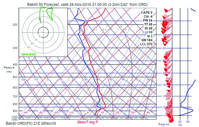
If you are truly a weather geek, you can learn how to read and interpret NOAA sounding data, available online at rucsoundings.noaa.gov. Soundings are atmospheric profiles that stations provide from data gathered from either models or weather balloons. Sounding data are typically displayed in a Skew-T log (p) chart. The Skew-T log (p) diagram provides environmental temperature, dew point temperature and wind as a function of pressure (which correlates to altitude). Data from a weather balloon is shown as actual conditions or RAOB (for radiosonde observation).
Fully deciphering a Skew-T (at right) may take some study, but here are some quick pointers:
• The basic, underlying chart doesn’t change.
• Data are plotted with red lines for temperature, blue for dewpoint and green for shearing wind.
• Wind velocities are plotted on the rightmost scale.
• Instead of altitudes, the Skew-T identifies pressure, and you need to know the ambient pressure at your planned altitude (e.g., 800 mb is approximately 5500 feet msl, while 500 mb is approximately 18,000 feet, or FL180).
The Added Risk
If you’re VFR-only and plan to get on top of a cloud deck in a VFR-over-the-top operation, you’ll have fewer choices if something goes wrong. If you took a sucker-hole bet to get on top, and somewhere along your route VFR conditions close out or become otherwise untenable, you must either find a new sucker hole or turn around back toward the one you came through, hoping it’s still there.
A VFR pilot in this situation has to make a good decision. When in doubt, I vote for confessing your situation to ATC and seeking their help to navigate to a location with better conditions or a hole closer to your current location. If ATC isn’t answering or responding, this may require declaring an emergency.
I’ll be blunt—entering IMC as a VFR pilot can be a recipe for disaster. According to the AOPA Air Safety Institute’s 25th Nall Report, the category of weather-related accidents, “attempts to fly by visual references in instrument conditions (“VFR into IMC”) accounted for the lion’s share of fatalities” in 2013. Specifically, VFR into IMC was the largest weather-related accident category, reporting 23 accidents, of which 74 percent were fatal.
Before you run completely out of options, it always is safer to declare an emergency. If, after climbing through a sucker hole, you use too much fuel looking for another so you can get back down, you are in trouble. You made a bad decision, but you don’t have to keep making them. Declaring an emergency breaks the cycle.
Declaring an emergency gives you at least one extra set of eyes to guide you. Even better, pilots who were too lazy to make reports will likely pop up on frequency with reports that might improve your situational awareness. The layer 20 miles west could be broken rather than overcast, and another 20 miles west, it may become scattered. If you don’t declare the urgency of your situation, no one is going to volunteer potentially life-saving information.
What a VFR-only pilot absolutely does not want to do is enter the clouds by their self. A VFR-only pilot has no business there—not because it is some elite club, but because it is not likely to end well.
Climbing On Top Isn’t Always A Good Idea
As useful as cruising above a cloud deck can be to your normal operations, IFR or VFR, there are some things that make it a poor choice sometimes, along with some other factors you should consider. For example:
Ice
When you are above the freezing level and aren’t equipped for it, you are rolling the dice. If you have an engine failure or other emergency, it will be the beginning of your troubles.
Layers
Flying above a simple fog layer is one thing; flying into a frontal system with multiple cloud layers is asking for trouble when IFR is not an option.
No VMC below
When all the airports below you are reporting less than 200-foot ceilings, you may not have many options.
When IFR isn’t possible
If you aren’t IFR-capable—you aren’t current or the airplane isn’t equipped—you’re taking a greater risk hopping above the cloud tops thinking your IFR ticket will save the day if you run into problems. Stay proficient, fix the airplane and have a flight plan on file as your hedge.
Staying On Top
There’s a time and place for everything. Once you get on top of a cloud deck, there may not be a hole available to get down when you need it. You have a lot more options if you’re IFR-capable.
Just remember: what goes up must come down.
Mike Hart is an Idaho-based flight instructor and proud owner of a 1946 Piper J3 Cub and a Cessna 180. He also is the Idaho liaison to the Recreational Aviation Foundation.


