
In less than 25 years, the “miracle” of GPS has transformed how even the smallest and least expensive aircraft navigates. Thanks to the wide area augmentation system (WAAS) in the U.S. and similar technologies deployed in other countries, GPS is more accurate, more reliable and more repeatable than what came before. If you need proof, look no further than comparing the faithful instrument landing system (ILS) to its WAAS GPS-based equivalent, the LPV (localizer performance with vertical guidance) approach. In typical configuration, either one can take us down to 200 feet agl and a half-mile visibility. There are other similarities, of course, including how we fly them. But which is better?
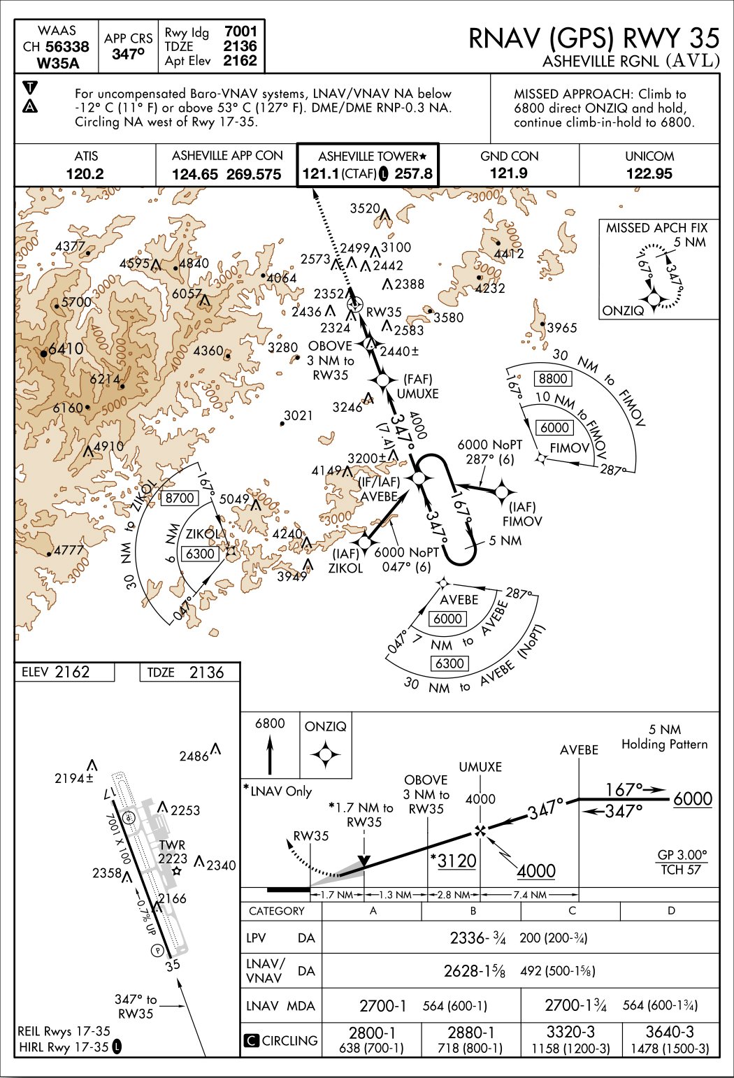
Some pilots are convinced the steadier signal digital GPS provides—when compared to the waviness of the analog ILS localizer and glideslope components—makes WAAS-enhanced approaches a no-brainer, even when there’s an ILS serving the same runway. At the same time, there’s something rather simple and perhaps romantic about an ILS. But when ATC wants to know which approach you’re requesting, do you automatically choose the newfangled GPS procedure or do you go with the old standby, the ILS? Which is best? As with so many things in aviation, it depends. By way of explanation, we’ll take close looks at two procedures serving the same strip of pavement, Runway 35 at the Asheville (N.C.) Regional Airport. Approach plates for both procedures are reproduced on this and the opposite page.
Equipment Requirements
Of course, if the panel you’re flying behind doesn’t include a GPS navigator installation approved for LPV approaches, the question is moot. There aren’t that many choices on the market for approved boxes, and—by design—they all work basically the same way. If your aircraft legally can fly an LPV procedure, including consideration of the navigation database’s status, you’re good to go. If not, your GPS still may be able to provide guidance for an LNAV or LNAV/VNAV procedure. Be sure the unit’s annunciators agree with which minima you expect to use.
The ILS also requires some airborne equipment, including receivers for the localizer and the glideslope, plus an appropriate course deviation indicator. If you have a working nav radio equipped with a CDI sporting a glideslope, you’re probably in business. While the GPS likely must have a current database, a VOR check within the preceding 30 days is all that’s necessary to use the ILS. (I’m sure all of us are completing that paperwork every 30 days, right along with logging when we update the GPS navigator’s database.) These days, most aircraft flying in the IFR system have one of each: a GPS navigator and an ILS, so it may seem to be a toss-up in most conditions. The decision starts to get more complicated when—for whatever reason—we can’t use the ILS or LPV minima.
For example, if you’re using the localizer-only minima of the ILS in an airplane that lacks a glideslope or two working VOR receivers and ATC can’t identify the OBOVE intersection/fix for you, you’re stuck with a 3100-foot minimum descent altitude (MDA). That’s 964 feet above the touchdown zone elevation and not much better than VFR. Since it’s also the circling MDA when you can’t identify OBOVE, you have the option of maneuvering to land on Runway 17, but you always have that option once you break out. If your glideslope is inop, identifying OBOVE by shooting the 264-degree cross radial off the Sugarloaf Mountain Vortac means you’ll need dual working VOR receivers.
If your GPS navigator doesn’t have LPV capability, LNAV/VNAV is your next best choice, as usual. You can get down to 492 feet above the touchdown zone, which is better than the ILS procedure’s localizer-only MDA even when OBOVE is identified. With LNAV only, you’re in localizer-only territory, with one exception: You don’t have to identify OBOVE to get that MDA.
Finally, note that an ADF is required for the ILS/LOC procedure, to identify the Broad River NDB, an intermediate/initial approach fix and where you’ll be holding if there’s a crowd. These days, it’s uncommon to find a working ADF in personal airplanes, but longstanding FAA policy allows you to use an approved GPS as a substitute. “Approved” means you can’t rely on your iPad’s electronic flight bag app but must use an installed GPS navigator that’s legal at least for en route and terminal operations. See the sidebar on the previous page for additional details on substituting GPS for an ADF or DME.
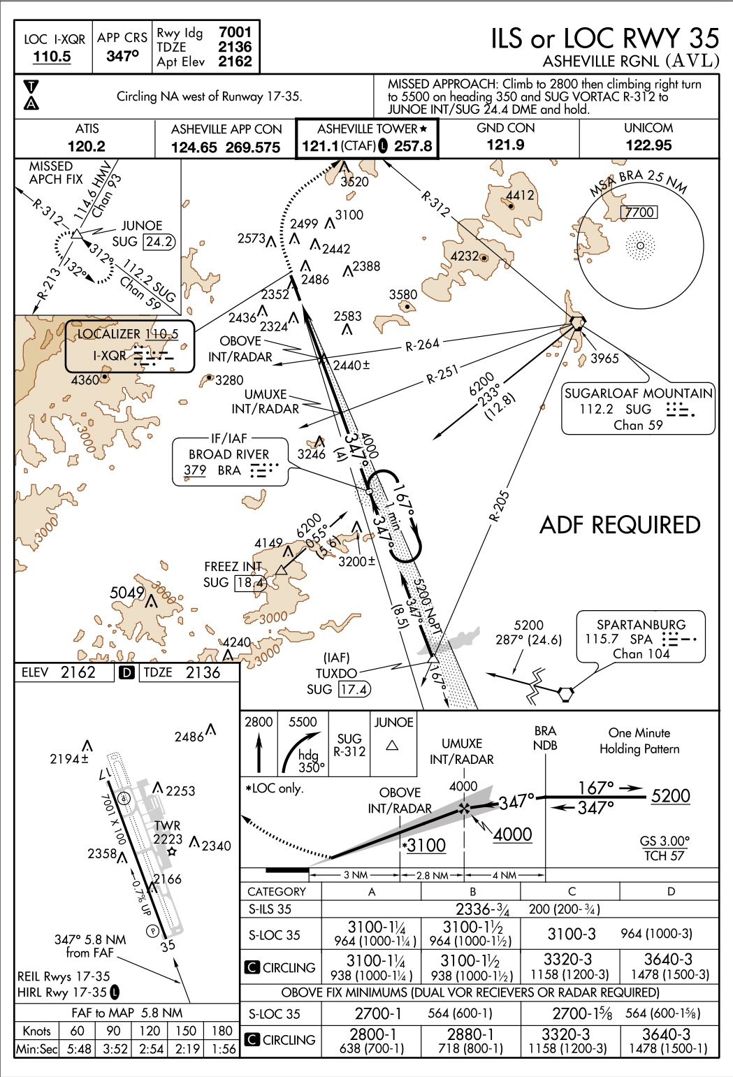
That’s pretty much it for the equipment requirements. If everything’s working, the ILS and LPV minima are the same, while the RNAV procedure offers lower MDA choices over the localizer-only minima when you can’t identify OBOVE. If you can use the OBOVE minima, it’s another toss-up. The worst case is if you only have a single VOR receiver lacking a glideslope. If so, you’re basically stuck with VFR minima. And you still need an ADF or IFR-approved GPS to identify the Broad River NDB.
Substitutions Allowed
When IFR-approved GPS navigators first became a thing, and before there were dedicated GPS approaches, the FAA wisely allowed pilots of equipped aircraft to use their new toy as a substitute for other avionics, most notably an ADF or a DME. That’s still doable, and the FAA’s current guidance on using GPS in lieu of other equipment is found in Advisory Circular AC 90-108, Use of Suitable Area Navigation (RNAV) Systems on Conventional Routes and Procedures.
Under the AC and referenced documents, there are two basic ways to use GPS: as a substitute when either the airborne or terrestrial equipment is inoperative, or as an alternative. Using a GPS to identify the Broad River NDB when you don’t have an ADF aboard is an example of the former while using it to fly a Victor airway instead of your working VOR is an example of the latter. As always, it pays to review appropriate guidance and consider your airplane’s equipment, and your operational needs, before planning to substitute your GPS for something you don’t have.
How many approaches are there, anyway?
One thing the advent of GPS seems to have done is increase the number of published approaches. Since most runways can support some kind of approach, it makes sense to create GPS-based procedures at locations where it isn’t economical or practical to install ground-based navaids so we can shoot an approach to a nearby airpot. Among the other ramifications, you may be confronted with the ILS-or-LPV question more often, which is a good thing in our book.
But an ILS or an LPV isn’t our only choice, at least in the U.S. The FAA maintains an ongoing list of the number of instrument procedures, including departures and arrivals, as well as other approach types. Of course, the number of published approaches depends on how they’re counted. As the table below details, the FAA generally counts them by lines of published minima,
Regardless, the number of GPS-based approaches (LPV, LNAV and VNAV) far outstrips ILS, LOC and VOR when combined. Eventually, we’ll likely see many CAT I ILS procedures phased out in favor of something based on GPS, or its successor.
The FAA’s summary of the various approach types, as of October 12, 2017, is reproduced below.
Circling To 17
I’ve been going in and out of Asheville since forever. Things there have changed somewhat over the years, including renumbering the runway from 16-34 to 17-35. Another thing that has changed is that the ILS to Runway 35 (ne 34) used to support a back-course localizer procedure to the opposite end of the runway. Back then, it was Runway 16, and I’ve shot the LOC-BC procedure in anger. These days, there is an RNAV (GPS) procedure to Runway 17, offering LPV minima down to 250 feet above the touchdown zone. That’s a quantum leap forward when arriving Asheville from the north.
But let’s presume you’re arriving from the south and the winds or some other operational consideration make landing on Runway 17 your preference. Rather than use the straight-in minima associated with either the ILS or the RNAV, you can break out and circle to 17 if the ceiling is high enough. Maybe.
Right, off you need to know that circling to the west of Asheville’s single runway at night isn’t authorized. If you’ve ever been to the airport in the daytime, you’d know why: There are some hills out there, fairly close to the runway, that you don’t want to tangle with. In fact, we’d strongly suggest not circling to the west at Asheville even in the daytime, although doing so is legal.
If you want to circle to land on Runway 17 at Asheville, both procedures offer the same minima: 2800 feet msl is your Category A MDA, presuming you can identify OBOVE when using the localizer-only procedure, and the same MDA is available when using the RNAV approach. The only real caveat harks back to an airplane with only a single working VOR receiver and no glideslope: Without identifying OBOVE, you’ll be stuck with a 3100-foot circling MDA since there’s no non-GPS approach option for Runway 17.
Finally, note that the Runway 17 threshold is a full 50 feet higher than the one for Runway 35—the planview shows a 0.7-percent slope between the two. If you need the full 7000 feet of runway, maybe you shouldn’t be using 17 anyway. Wind conditions probably will be your guide.
Missed Approach
Because Asheville is in the mountains, its weather can be unpredictable for out-of-towners. With a 200-foot DH/DA for either approach to Runway 35, you’ll likely get in the first time. But the missed approach instructions for the two procedures differ in what could be significant ways for you.
The easiest miss at Asheville is associated with the RNAV procedure. It calls for a straight-out climb, to 6800 feet msl, to the ONZIQ intersection/fix. ONZIQ forms an intermediate/initial approach fix for the RNAV Runway 17 procedure, and is 13.6 nm from its threshold. That makes it roughly 15 nm from the missed-approach point (MAP) on the approach to Runway 35. Presuming you’re shooting the LPV portion of the RNAV procedure and descend all the way down to 2336 feet msl before initiating the miss, you’ve got 15 nm to climb to ONZIQ’s 6800-foot minimum holding pattern altitude. At 120 knots groundspeed in the climb, it’ll take you 7.5 minutes to reach ONZIQ. You’ll need roughly a 600-fpm climb rate to reach 6800 feet at ONZIQ, or you can continue climbing in the hold. Because ONZIQ is straight-out on the miss, it might be preferable to you if there’s a chance of going missed on either the ILS or the RNAV approach.
Did I mention Asheville is in the mountains? It can get cold there in winter, and airframe icing often is a consideration. In such situations, climbing to 6800 feet msl on the miss may not be your first choice. If it’s not, the ILS procedure may offer a better deal if there’s a likelihood of missing. It requires climbing only to 5500 feet msl, but does involve a climbing right turn after reaching 2800 feet. The holding fix for the miss, JUNOE, is 16 nm from Runway 35’s threshold as the crow flies. You’ll need a climb rate of roughly 400 fpm to reach it.
Other Considerations
As always, weather should be a primary concern when making operational decisions. In Asheville’s case, there’s breathtaking scenery in clear daytime conditions, but those same features can translate into being forced to remain high when you really want to get lower. Like when there’s the likelihood of ice a few thousand feet above sea level.
Airports surrounded by mountains can pose interesting problems when there’s ice about, and Asheville is no exception. The local approach facility’s minimum vectoring altitude, reproduced above, only tells part of the story. Another part is the minimum altitude for published portions of the approach. The profile views for the ILS and RNAV procedures complete the picture, and the ILS may offer an advantage as its highest published altitude is 5200 feet. It’ll save you 800 feet over the RNAV procedure, if that’s a concern. If it’s that much of a concern, of course, we’d suggest going somewhere else.
Another part of the equation is the minimum safe altitudes the two procedures depict. Within 25 nm of Broad River, the MSA is 7700 feet msl. But the RNAV procedure’s chart shows only 6300 feet as far as 30 nm south of the AVEBE initial approach fix, but you’ll still need 6000 feet crossing it. Much higher MSAs exist in other directions.
In my book and all other things being equal, the approach to use is the one that’s easiest to set up and offers the greatest risk of success. Whether that’s the ILS or the LPV depends on equipment and conditions.
Jeb Burnside is this magazine’s editor-in-chief. He’s an airline transport pilot and owns a Beechcraft Debonair, plus half of an Aeronca 7CCM Champ.


