During my primary training, one of my mentors was fairly adamant about the threat of weather. If I had the skills, wisdom and experience, and the airplane was in good condition with sufficient fuel, he would point out, the only other big thing that could be a safety-of-flight problem was weather. The primary concerns he expressed included thunderstorms and their turbulence, low ceilings that engendered scud running and fog that blanketed the airport.
As I gained more experience, including an instrument rating, my weather understanding never really progressed beyond those big three hazards, plus airframe icing as I logged more IMC. It was more a matter of convincing myself I didn’t need that additional knowledge—I’d already made up my mind that I wasn’t going to fly in those conditions—than an outright refusal to learn more. On one of my first forays into IMC as the pilot in command, I learned a hard lesson on cold fronts.
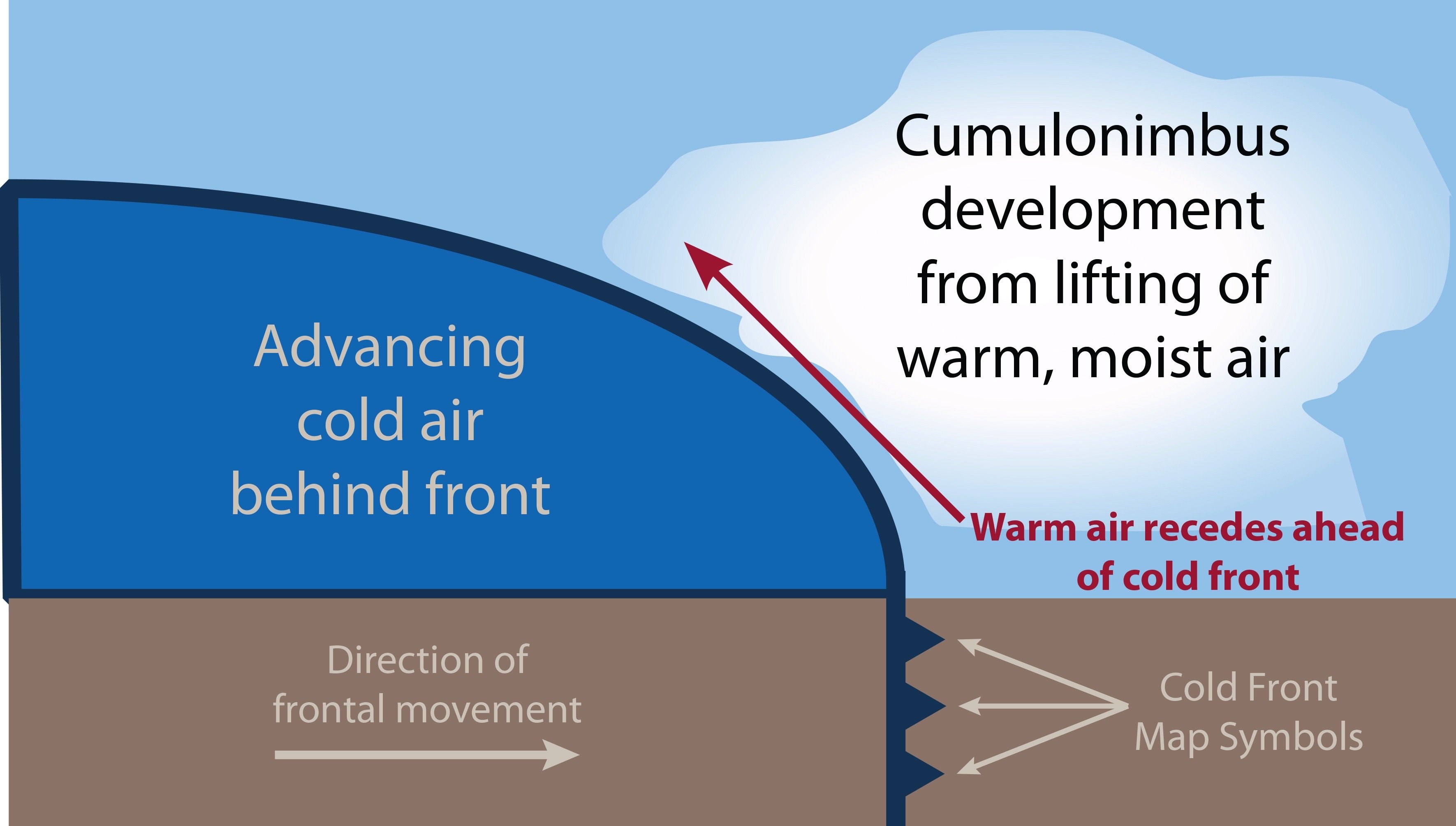
The thing about cold fronts is they can combine many of the aforementioned weather hazards into a single package. As the colder, denser air slides under the warmer mass, lifting occurs. And it can be enthusiastic. In many situations, the only reasonable thing to do is land and let the cold front pass, then launch into cooler, clearer air.
Warm fronts, as their name implies, typically mean warming, stable, slow-moving air, along with lowered visibilities and perhaps an occasional air-mass thunderstorm.
The thing is, aviation meteorology is pretty good at identifying and predicting both kinds of fronts. Checking the surface analysis immediately shows their position and type while the prog charts give us a pretty good idea of where they’re headed. The only real trick is checking and understanding the weather situation, especially when launching on a night flight in winter.
Background
On November 19, 2016, at about 1902 Eastern time, a Ryan Navion A impacted wooded terrain while maneuvering near New Gretna, N.J. The private pilot was fatally injured and the airplane was substantially damaged. Night visual conditions prevailed.
Earlier, the accident pilot and another pilot flew their airplanes to dinner at Hummel Field (W75) in Saluda, Va. After dinner, they both added fuel and departed about 1730 for separate destinations, with the accident pilot headed for the Ocean County Airport (MJX), Toms River, N.J. While en route, they communicated with each other. On reaching his destination, the friend-pilot experienced wind shear and advised his friend of the conditions. The accident pilot acknowledged the warning. The friend radioed the accident pilot again about 1830 to check on him, and he replied that he had reached the Delaware Bay. No further communications were received from the accident pilot.
Investigation
A review of weather information and FAA radar data revealed the accident flight proceeded on a relatively direct course until about 1849, when it encountered the leading edge of a cold front. During the following 13 minutes, the flight completed numerous course deviations, including three complete left circuits and two right circuits, before impacting wooded terrain. During the last three minutes of radar data, the airplane’s altitude varied between 2100 and 200 feet msl as it completed the two right circuits and one of the left circuits, before impacting terrain. The last target was recorded at 1902:36, when the airplane was about 2000 feet southeast of the accident site, at 525 feet msl.
The debris path extended about 420 feet, where the main wreckage came to rest inverted with both wings separated. The right main and nose landing gear were extended; the left main landing gear had separated. Control-cable continuity was confirmed from the cockpit to the wing roots, and to the empennage, where they exhibited broomstrawing consistent with overload. The propeller remained attached to the engine. Both propeller blades exhibited S-bending, chordwise scratching, leading edge gouging and tip curling, consistent with being under power at impact.
The accident pilot’s destination was about 16 miles northeast of the accident site. At 1856, recorded weather there included wind at five knots, three statute miles of visibility in mist and clear skies. Meanwhile, the Atlantic City (N.J.) International Airport, about 14 miles southwest of the accident site, recorded wind from 290 degrees at 24 knots, with gusts to 31 knots, at 1730, about the time the pair took off.
The accident pilot’s friend reported obtaining a weather briefing about 1630 via Flight Service for both flights, and telling him that the weather was forecast to deteriorate near his destination airport between 1900 and 1930. The friend also reported plotting a route on the pilot’s iPad using Garmin Pilot. A search of Flight Service records did not reveal any contact from either airplane’s registration numbers on the day of the accident, and neither ForeFlight nor Garmin had a current subscription for the accident pilot.
The 75-year-old private pilot was not instrument-rated. He had owned the airplane since 1993.
AIRCRAFT PROFILE: Ryan Navion A
FlugKerl2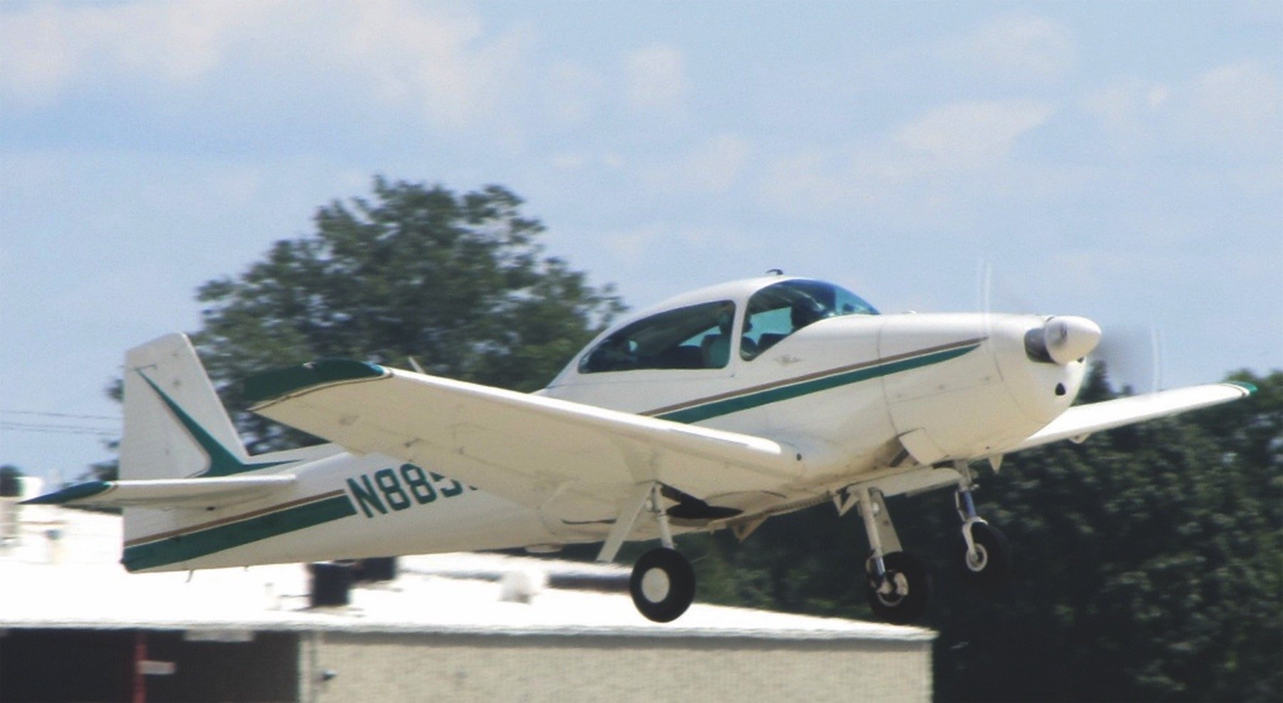
Engine: Continental E-185
Empty weight: 1782 lbs.
Max gross TO weight: 2750 lbs.
Typical cruise speed: 135 KTAS
STANDARD fuel capacity: 40 gal.
Service Ceiling: 15,600 feet
Range: 430 nm
Vso: 57 KIAS
Probable Cause
The NTSB determined the probable cause(s) of this accident to include: “The pilot’s inadequate preflight weather planning and in-flight weather evaluation, which resulted in an encounter with a strong cold front and the pilot’s subsequent loss of airplane control.” Yes, this accident ultimately will be attributed to losing control. As the NTSB highlights, inadequate weather planning and evaluation also play major roles. What does that tell us?
One thing it tells us is this accident has a longish chain. It started with the pilot not having an instrument rating. It lengthened with a night flight and got stretched even more by the pilot’s failure to obtain and understand a preflight weather briefing or letting his electronic flight bag do it for him. Along the way, considerations like being relatively close to the airplane’s base and perhaps a warm, familiar bed—along with a very familiar airplane—may have combined to lure the accident pilot into a false sense of security. His last warning about the weather in front of him was literally radioed to him by his pilot friend.
Applying even basic risk management principles to this flight—one conducted at night, without a weather briefing and without an instrument rating—would have rung some loud bells. Put aside the natural peer pressure of two pilots flying more or less together, it’s always up to you to brief the weather conditions. Don’t expect even a good friend to do it for you.
Cold Front Characteristics
According to the FAA’s Pilot’s Handbook of Aeronautical Knowledge (PHAK, FAA-H-8083-25B), “A typical cold front moves in a manner opposite that of a warm front. It is so dense, it stays close to the ground and acts like a snowplow, sliding under the warmer air and forcing the less dense air aloft. The rapidly ascending air causes the temperature to decrease suddenly, forcing the creation of clouds. The type of clouds that form depends on the stability of the warmer air mass. A cold front in the Northern Hemisphere is normally oriented in a northeast to southwest manner and can be several hundred miles long, encompassing a large area of land.
“Prior to the passage of a typical cold front, cirriform or towering cumulus clouds are present, and cumulonimbus clouds may develop. Rain showers may also develop due to the rapid development of clouds. A high dew point and falling barometric pressure are indicative of imminent cold front passage.
“As the cold front passes, towering cumulus or cumulonimbus clouds continue to dominate the sky. Depending on the intensity of the cold front, heavy rain showers form and may be accompanied by lightning, thunder, and/or hail. More severe cold fronts can also produce tornadoes….”