
I used to ground myself when I saw a forecast of thunderstorm weather. I had an immediate visceral response rooted in memories of growing up in Kansas, seeing vast tornado-spawning squall lines, their blue-green tint indicating they were pregnant with hail. At age 11, I watched a barn across the road explode in one of those storms, flying in pieces across the fields, followed by a barrage of baseball-sized hail. Surely you can’t fly when convective weather and thunderstorms are nearby or on the way, can you? Well, Dorothy, sometimes you can. You just need to know what to look for and what to avoid.
Not The Same
Thunderstorms may differ in the ways they form and move, but inside, they are all the same, something to be avoided. Air mass thunderstorms—often called pop-up thunderstorms—behave quite differently from the violent thunderstorm systems of the southern midwest U.S., a region also known as Tornado Alley, the kind associated with frontal passage or super cell formation.
Air mass thunderstorms usually form in the spring and summer. They can be caused by a combination of unstable air, solar heating, orographic lifting and an atmospheric trigger that lifts moist air parcels into areas of instability, amplifying buoyancy and propelling a building cumulus cloud to ever greater heights. Air mass storms typically pop up in the mid-to-late afternoon and are usually gone by late evening, after the solar energy driving them disappears.
Air mass storms generally are isolated, meaning you should be able to safely fly around them. One of the keys is to remain in visual conditions; if you can see it, you can avoid it. That said, you should never fly through or under a cumulonimbus cloud of any thunderstorm. Although some may consider the air mass flavor to be “weaker” than the frontal thunderstorm, either type can ruin your day.
Don’t get tunnel vision
The challenge of dodging air mass pop-ups is identifying them before they block your planned path, or anticipate them far enough in advance that you can work your flight path gracefully around them. The FAA recommends staying 20 miles clear of severe thunderstorms, but hedges that distance to 10 miles for weaker storms. How do you decide?
To size up a storm, pilots should always use visual cues and a combination of airborne weather radar, Nexrad imagery, a sferic (lightning detection) device, and tools like Convective Sigmets and Center Weather Advisories. If it’s passing over or near an airport or two, the current reported weather also will be helpful. I also look on the ground for cues of low-level winds, like ripples on water and vegetation, and blowing dust and smoke.
When Nexrad radar products show storms are producing only light precipitation (green returns), with perhaps just a small central core of moderate precipitation (yellow), I am more comfortable cozying up to within 10 miles, particularly if the gadget shows there is no lightning present. Technically speaking, it isn’t a thunderstorm until it produces lightning. Do this as long as you have a solid-gold out—a clear direction in which you can turn if things get ugly.
While 10 miles can be an acceptable distance to weaker storms, but 20 is always going to be better, particularly knowing that Nexrad images reflect the history of the storm rather than its current state. Sferic devices, on the other hand, operate in real-time, but they aren’t good at determining distance.
Dodging and weaving
The fast-building nature of air mass thunderstorms can present challenges, especially when several storms are developing in a general area and the space between cells is at play. The problem is they mature quickly, so as you dodge and weave, you may find your options get fewer as you get nearer. It is easy to find yourself leaving one cell behind just in time to see another one ahead.
Another thing to consider is whether your system is truly a single-cell storm or something more extensive. A line or system of more than one air mass storm could be reclassified as a multi-cell thunderstorm, but the visible difference between a single-cell air mass storm and a multi-cell system is not always clear. Multi-cell storms are much more dangerous because a pilot flying between cells may soon discover that the storms are growing and merging around them.
Doorways and blind spots
A mountain range or some low hills on your flight path can trigger the uplift that turns cumulus buildup into a storm that packs a bit more punch. The Oquirrh Mountains (pronounced OH-ker) southwest of Salt Lake City regularly produce summer storms with predictable regularity. The challenge of terrain-induced thunderstorms is that they create “doorways” that may be open only during the storm’s early building phase. Those doorways can close quickly while you are still in transit and making decisions. It is tempting to make a run for the door to get past a building storm, but use caution in mountainous areas where the clear path around a storm pushes you against rising terrain.
Another common doorway is the path between thunderstorm cells. The FAA warns that gaps of 20-30 miles between strong precipitation echoes will likely contain strong turbulence. If you choose to split a 40-mile gap between cells of moderate precipitation, you are pressing your luck. With strong precipitation, you are definitely pressing your luck. And if the cells in question have hail and lightning, you are just stupid. Your best bet is to use your eyeballs and any other visual cues, and don’t rely exclusively on radar echoes.
Radar blindspots, places where low-tilt radar is obstructed by terrain, are an additional complication. In mountainous areas, the further you get from a radar station, the more likely it is that the images displayed are painting the weather at higher and higher altitudes rather than actual surface storms. When you know you are in a radar gap, be skeptical of areas showing light precipitation. Trust your eyes before you trust green radar returns.
Intensifying factors
When there is a large difference between winds aloft and winds at ground level, a rising updraft can become vertically separated from the downdraft that forms when the weight of precipitation exceeds the lift of the rising air. With sufficient vertical shear, a storm can grow bigger and more violent because the feedback loop that feeds convection doesn’t conflict with the downdrafts that can short-circuit the storm’s building phase.
The same is true for rotation. If a storm cell starts to rotate, the atmospheric heating that feeds the storm separates from the area where downdrafts of falling moisture can cause a collapse in the storm’s structure. With more rotation, there is more chance for runaway buildup. An extreme example is when an entire storm system becomes a mesocyclone or supercell. Radar depictions showing rotation in a storm are an indication of great potential to intensify.
Outwash and Gust Fronts
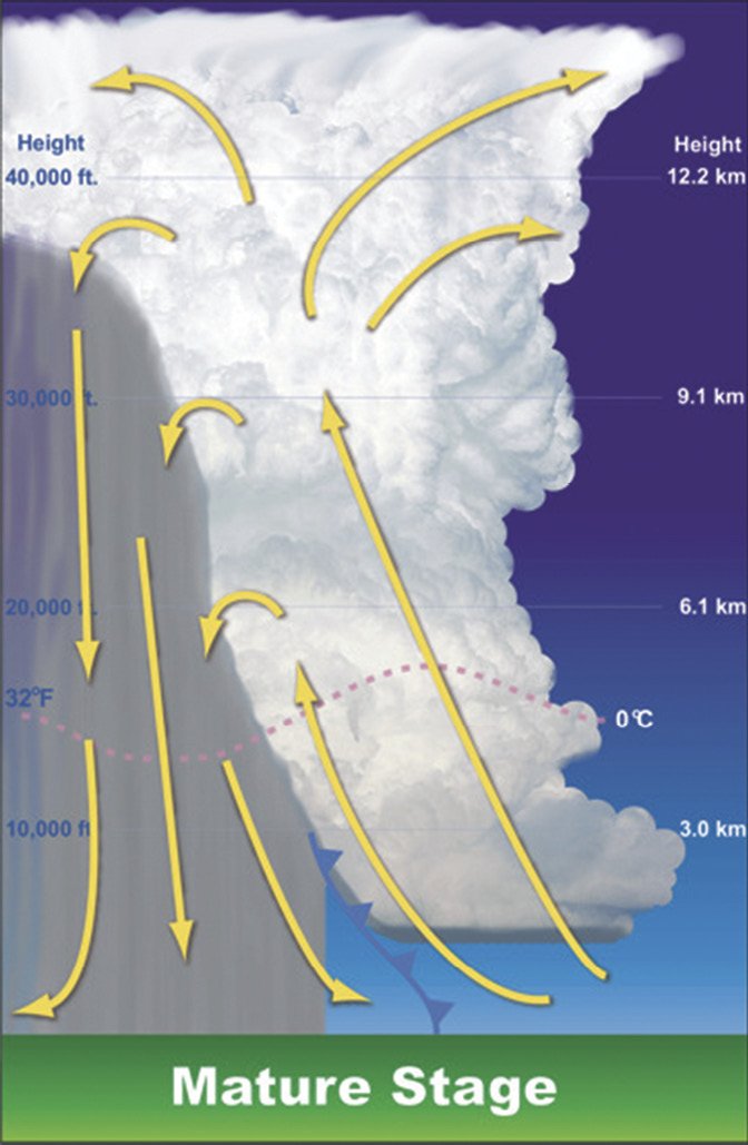
An air mass storm stops growing when the updrafts no longer support the weight of precipitation. The inrush of warm air gives way to downdrafts laden with precipitation, which can often contain ice, graupel and hail. The worst time to end up in an air mass storm is at its maturity, when violent updrafts and violent downdrafts are both present. The vertical windshear of updrafts next to downdrafts is enough to cause structural damage to your airframe, if not outright failure.
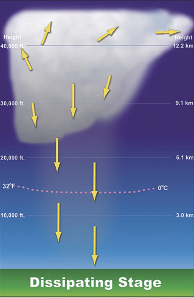
The storm enters its final dissipating stage when the inflow and updrafts finally stop and the storm is only downdrafts. While this may seem a less-violent stage than the vertical windshear of updrafts and downdrafts, it should not be confused with a diminution of the storm’s violence. From a pilot’s perspective, this is when storms are at their most dangerous. Just as no pilot would willingly fly into a building storm, no pilot should fly into a diminishing one either.
In the post-maturity dissipation stage, when downdrafts dominate, the storm’s footprint on the ground beneath can expand in the form of an outwash far beyond the edge of the storm. The outwash occurs when downrushing precipitation entrains and pushes air with it. When the downdrafts hit the surface, the outwash pushes away and ahead of the storm, often forming a bow wave that shows up on radar time lapses.
I have seen gust fronts of 20-60 knots push walls of dust in a sustained bow wave outward from a single air mass storm. To the naked eye, this outwash can look like straight winds pushing away from the storm, but these are essentially localized fronts, because there can be associated shifts of temperature, pressure and wind direction.
At ground level, storm outwash, gust fronts and microbursts can create the low-level wind shear we commonly understand as a hazard to aircraft. Imagine this scenario: At the same time you are ready to land to the south on Runway 18 with a 10-knot wind coming down the runway, there is a dissipating thunderstorm 10-20 miles to the west that will push a bow wave of strong wind from 29030G50. The place where that wind change happens is a zone of wind shear.
If you are on final and know there is a gust front, consider going round and waiting it out. Gust fronts are transient phenomena, and the wind shear it can produce is often temporary. When the gust front passes, you may be able to land.
Choose the backside
Thunderstorms build according to the physics that drive them, not by the names and classifications we give them. When you are concerned that thunderstorms may affect your blue-sky flight plans, a basic understanding of the atmospheric mechanisms that produce storms and a review of convection forecasts will help. (See the sidebar on the opposite page.)
If all things are equal, choose to pass behind both developing and mature air mass thunderstorms. You still need to keep your distance, but there is a significantly greater safety margin in traveling where the storm has been rather than where it is going.
It should be a misnomer to describe any thunderstorm as weak. While single-cell air mass thunderstorms are not in the same class as super-cell systems or squall-lines formed by fast-moving cold fronts, they should never be taken lightly, even when they are nicely scattered in a way that allows you to dodge and weave. With a little foresight and seriousness, you can keep it a blue sky jaunt and avoid too much challenge.
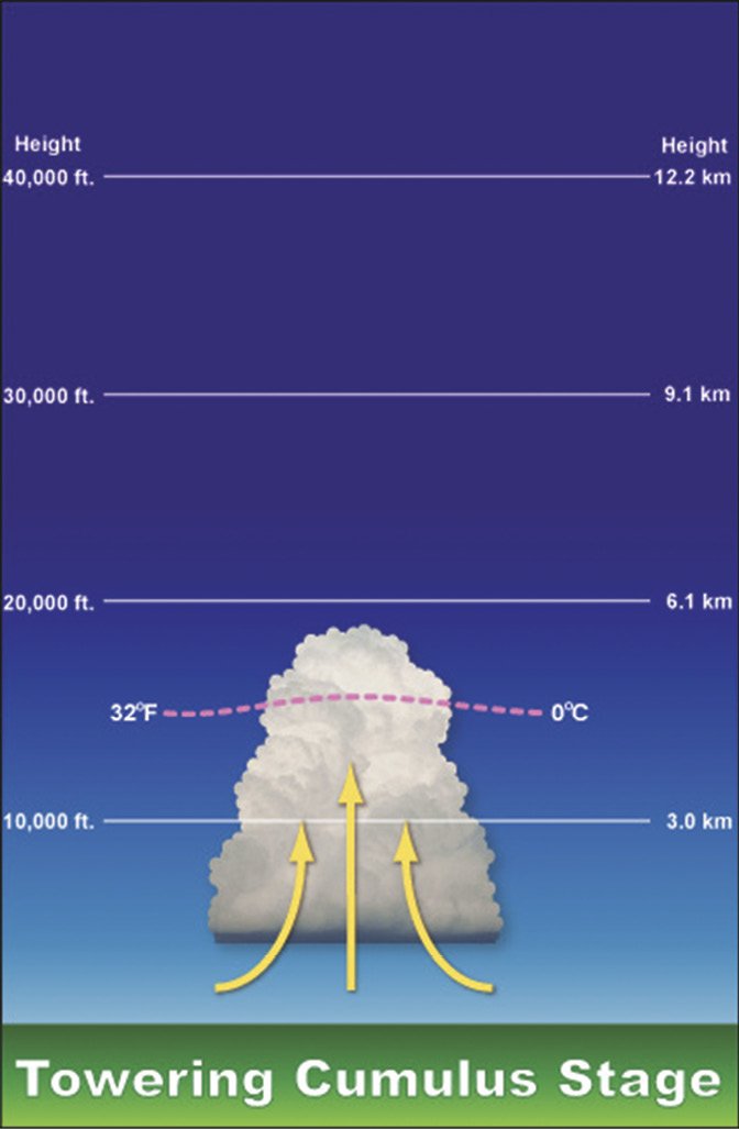
An air mass thunderstorm is birthed when solar heating and/or lifting triggers a parcel of moist air to rise. As it rises, the parcel cools from expansion and the moisture it contains condenses, forming clouds. The act of condensation gives off heat that increases the parcel’s buoyancy. As long as the parcel of rising air is more buoyant than the surrounding air, it will continue to rise.
With enough oomph, rising air can break through the containing area of atmospheric stability, and if conditions are right, all hell can break loose. The buoyant air becomes an updraft and precipitation forms. As it is carried higher, water droplets can freeze, giving off even more heat, which adds further buoyancy. For more details, see the sidebar about checking convection forecasts on page 18.
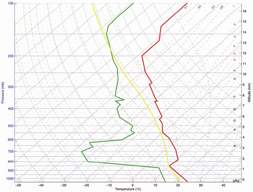
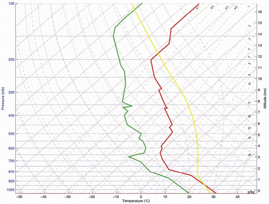
Both CAPE and CIN reveal themselves in the form of Skew-T diagrams, which are based on balloon soundings combined with models that project these tendencies toward instability (CAPE) and stability (CIN). At right, two successive Skew-T charts are reproduced.
The top diagram depicts the morning sounding detecting a decrease in the dew point (green line) with relatively constant temperature (red line). At bottom, the diagram depicts conditions later the same day, with the reduced dew point earlier in the day acting to lower temperatures.
Other tools are available, of course, including the convective outlook and convective forecast, plus convective Sigmets.
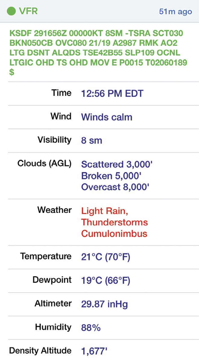
Check the TAF at your arriving aerodrome, which will show the five sm radius from the center of the runway complex. If you see the words, “showers in the vicinity,” that’s a good warning because forecasters are loathe to put thunderstorms in TAFs until there is a degree of certainty that a storm will be arriving. And of course, if a TAF or Metar says there is a thunderstorm at the airport, you won’t be able to maintain 20 miles of separation.
Mike Hart makes his living as an Idaho-based passenger, cargo and backcountry pilot. He also is the Idaho liaison to the Recreational Aviation Foundation.


