
Don’t you hate it when this happens? “November 12345, I have an amendment to your clearance…advise when ready to copy.” Then ATC gives you the barely pronounceable name of a waypoint you never heard of. You’re given a re-route around restricted airspace or a military operations area (MOA) that just went hot. Or you’re making a short positioning flight in IMC, and have to make rapid-fire GPS flight plan updates and heading changes when you’re cleared for a approach just as you’re leveling off from climb.
The tremendous utility, accuracy and repeatability of GPS allows us to file and fly direct routings much of the time. But if you’re a fan of airport-to-airport, point-to-point flight plans and routings, chances are good you’ll have to deal with attention-grabbing updates from ATC. To reduce your workload and limit the number of revised routings—to “plan your flight and fly your plan” with greater predictability—sometimes it helps to plan and file more smartly than simply hitting the Direct button.
Around the airspace
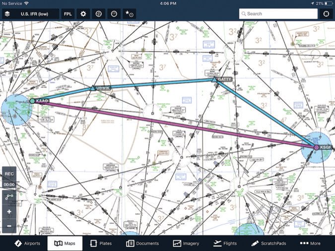
I’m based in Wichita, Kan. I occasionally fly to Springfield, Mo. A direct route, which clearance delivery always seems willing to approve, takes me through the Eureka MOA. Of course, IFR operations are prohibited in an active MOA. The MOA is not commonly expected to be hot, which is how I brief and file, but my experience is that somehow it is almost always hot once I get in the air. (Something about me being airborne seems to attract high-performance jets.)
This means I’m usually re-routed or simply vectored around, sometimes abruptly from a point inside the MOA when the Air National Guard decides it’s time to start mixing it up. I’d much rather file and be cleared for a route around the MOA. I use UBWIK GATTY Direct, so I have less chance of having to update my routing and my flight plan en route. That route is depicted on the en route chart shown below in blue, with the direct route in magenta.
That may seem like it’s way out of my way, but in the Bonanza I fly it usually adds only four minutes to the time en route. And, once past the corner of the MOA on the leg to GATTY I can ask for—and usually get—direct to destination. It’s easier and quicker to pick an existing waypoint on a GPS flight plan and “go direct” when I ask for it, than it is to find an unfamiliar waypoint and insert it into an existing flight plan when it’s convenient for the controller.
Going southeast, I file direct to the Bartlesville VOR (BVO) and onward. I fly to southwestern Ohio a couple of times each year, and although controllers will clear me direct to my destination airport if I ask, I’m always going to be routed around restricted areas R-3403A/B, which guard the western approaches to Cincinnati. So I add a fix or two to my flight plan that gets me around that obstacle. The result: “Cleared as filed” almost never gets amended.
STAR-crossed
Back when GPS was new and Loran still roamed the earth, I flew Beech Barons for a company in east Tennessee. Occasionally I’d have a run over to the Charlotte/Douglas International Airport (KCLT) in North Carolina to drop someone off or pick them up from a commercial flight. The airport was the home of USAirways, and even IFR getting in was always a hassle during the evening push, which is when I usually arrived. Approach would vector me around in all sorts of unpredictable ways until they found a gap in the jets for me to fill.
On a lark one night instead of filing direct to KCLT, I found a standard terminal arrival (STAR) procedure that coincided with my direction of flight, and I filed direct to the final fix on the STAR en route to my destination. This brought me onto the STAR at almost a right angle, but I got right in with no vectoring. On subsequent flights sometimes I was turned direct to the airport sooner, but I never spent 20 minutes on vectors flying around with controllers looking for a gap on their radar like I did when I filed direct. It seemed more efficient and smarter to do it this way.
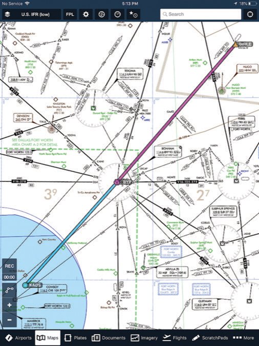
Back in Kansas, I found myself flying a few times to Addison, Texas (KADS), in the Dallas metroplex. I found the FINGR arrival (figure 3) and decided filing direct Bonham (BYP) then direct KADS might work. No, I was vectored all over the place. The next time I projected further out on the STAR course and filed direct to GAATZ, then the STAR to destination. Closing in on Dallas I was re-routed to BIRLE—which I had to have them spell phonetically, feeling like a freshman on frequency—and the STAR from there. Ah, I’d cracked the code. From that time on I filed from Wichita direct BIRLE, then the FINGR (I think it was FINGR4 at the time) to Addison. It worked every time…no fuss, no added workload in that high-intensity airspace.
Short approach
My employer’s Beech Bonanza was at Hamilton, Ohio, (KHAO, on the north side of Cincinnati) and I needed to hop it to Batavia, Ohio, (I69, on the east edge of the Cincinnati Class B airspace). A weather check revealed consistent ceilings at about 700 overcast throughout the Cincinnati area, visibility three to five miles in haze and occasionally one to three in light rain. Temperatures were well above freezing, so ice wasn’t a factor, and it was clearer just to the north around Dayton for an easy alternate. I filed to depart at around 0830 local, well after sunrise for daytime IMC lighting.
It’s my experience that in today’s magenta-line world, many pilots would file KHAO-I69 Direct (figure 4). Once airborne, they’d request an approach to the non-towered destination airport, load the procedure and when cleared for it, they’d activate it and turn to the initial approach fix (IAF). On a 10-minute flight in busy terminal airspace, though, this is a lot of work in a short time.
If I filed direct, there would be a lot of knob-turning, button pushing and heading-bug changing required, even while I was climbing out of Hamilton and leveling off at 3000 feet. Knowing that most deviations and crashes that occur in IMC are the result of distraction and pilot workload, I made a plan to minimize if not completely eliminate most of that on-the-fly programming.
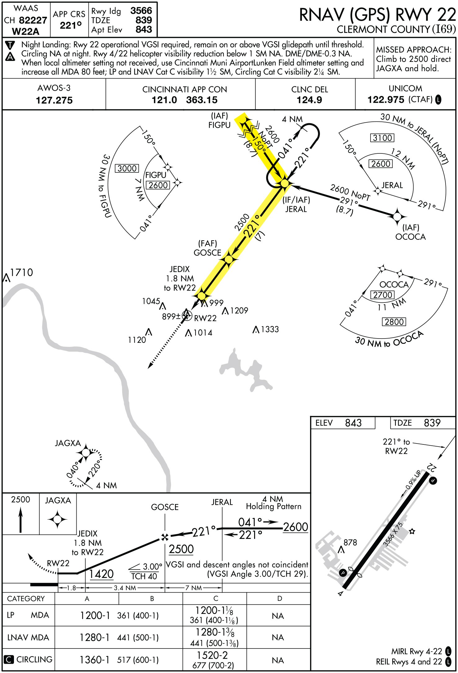
A quick look at the available procedures told me to plan on requesting the RNAV (GPS) RWY 22 approach, depicted at the top of the opposite page. At a non-towered airport, controllers will not assign a particular approach; they’ll ask what approach you request. It’s always your choice, although if there are other IFR airplanes in the area, your choice may mean having to wait if it conflicts with previously cleared traffic. Hamilton, too, is a non-towered airport, although there is a remote communications outlet (RCO) that permits talking directly to the local approach control while on the ground. The winds at Hamilton were light, out of the east, and IFR departures were using Runway 11.
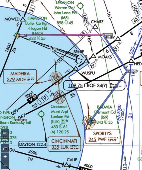
Knowing all this permitted me to formulate a plan to significantly reduce my workload as I navigated through an IFR departure directly into an IFR arrival in busy terminal airspace. It may not have been obvious, but it was stone-simple: File from KHAO direct to FIGPU, an initial approach fix (IAF) for the procedure, then direct to JERAL, hang a right and fly to my destination airport. It’s the route depicted in the ForeFlight screen shot, the bottom image on the opposite page.
I would probably get the same approach if I filed direct from KHAO to I69, but there’s a much higher likelihood of getting what I want (and I could load the GPS flight plan accordingly before I ever took off) if I filed it as my preplanned route of flight. Because there was a chance I’d have trouble finding an opening to talk on busy frequencies, it made more sense to me than short-cutting from Hamilton direct to JERAL. It also would keep me further away from the approaches into Cincinnati Lunken Field, a major business jet destination.
Doing It
So that’s what I filed. A few moments later, a ForeFlight message told me it was accepted as my expected route of flight. I briefed the I69 approach and a possible return to Hamilton if circumstances mandated a quick approach and return. I started the engine and had completed checklists and the run-up before calling on the RCO frequency and got my clearance: “As filed, 3000 feet.” The controller surprised me by advising I was released, but my clearance would be void if I was not airborne within 10 minutes. Now certain my filed route was as I’d planned, I quickly activated the flight plan in the Bonanza’s GNS 530: KHAO, FIGPU, JERAL, I69. Then I taxied to the end of 11, completed my final checks and launched.
Reporting airborne, the frequency got busy as I neared FIGPU—just as I’d expected it might. I didn’t have to wait to be cleared for the approach; I simply followed my cleared route and turned toward JERAL. About halfway to that fix, the controller asked me what approach I requested at Clermont County. (He had to know based on my route, but he also had to ask). I replied and was cleared for the RNAV (GPS) 22. All I had to do then was select and activate the approach, which required no change in heading or heading bug position because I had set myself up for the lowest possible workload. I slowed, ran my approach checklist, turned inbound and eventually broke out around three miles from the end of the runway.
The shortest flights can have the highest workload. There may be little to no en route phase of flight to scale back from the process of departure and to select, brief, load and execute the approach. With this strategy, however, I was always well ahead of the airplane and never had to scramble to set up for what came next. I was fully in command of the flight. I was flying smarter than “direct.”
Use your avionics to your fullest advantage to reduce the workload of IFR flight. Today’s GPS gives us great flexibility, even more so if we use it wisely. Sometimes this means flying smarter than simply pushing “direct.”
Cracking ATC’s Code
An educated guess led me to cracking the code of ATC’s double-secret terminal routing when trying to get into Addison (KADS) from the north. After putting up with a button-pushing arrival by choosing the wrong STAR, I figured out the fix I was going to go over—the Bonham Vortac (BYP)—and filed to route my flight over the next fix upstream on the FINGR arrival. It worked like a charm.
That was then; we have better tools today, and they’re easier to implement. The sidebar on the following page explores those tools in greater detail. The basic idea hasn’t changed, though: Figure out where ATC wants to send you, and file that route to minimize the button pushing.
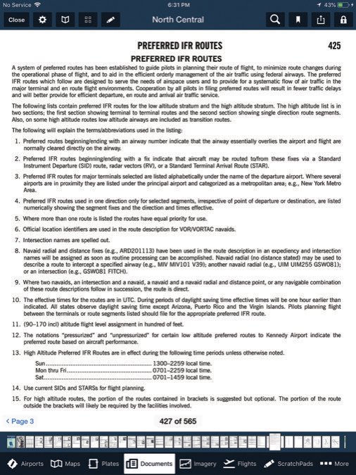
IFR Preferred Routes

All this talk about going direct, or not, is an option for flying in the vast majority of the country. In some regions however, notably the Mid-Atlantic, the Northeast and Southern California, and other areas on a smaller scale, the volume of traffic and proximity of major airports are great enough that ATC generally keeps airplanes on established routes. (They have to put us together to keep us apart.) To keep your workload low, it makes sense to anticipate these routes when you can and file them, because if you don’t you’ll probably be cleared differently than you filed or be rerouted anyway.
The FAA’s IFR Preferred Routes are those routes air traffic controllers use to reduce their workload in these high-volume areas. Preferred Routes are found in the Chart Supplement (formerly the Airport/Facilities Directory). Planning a trip in busy airspace? Check for IFR Preferred Routes and file to “go with the flow.” The Chart Supplement usually is available in the documents storage section of your favorite EFB app, or you can download it from the FAA’s web site.
The FAA also has a web page allowing users to input departure and arrival airports, airplane type and other variables, as well as to receive an IFR Preferred Route if one exists for that flight. There’s also a link to the entire FAA database of preferred routes, a lengthy PDF listing every IFR Preferred Route alphabetically by departure point. Enjoy the read.
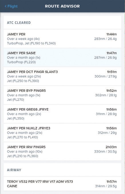
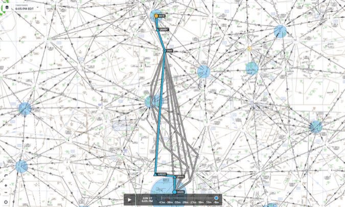
Web- and app-based flight planning services likefltplan.com,. ForeFlight Mobile and others include a “route advisor” function. File a route and the software may suggest something different based on IFR Preferred Routes or simply by checking the most common recent clearances issued for similar departure and destination airports.Fltplan.com. separates this further between piston, turboprop and jet airplanes. Regardless of the service you use, route advisors help you find a route that is unlikely to be changed once you are in flight.
Tom Turner is a CFII-MEI who frequently writes and lectures on aviation safety.


