
If you’re like us, you have multiple sources for aeronautical data—charts—that can be in digital or paper format. Also like us, maybe the digital data you use in the cockpit comes from different vendors, even if it’s the same basic information. Everyone makes mistakes from time to time, even the FAA, with the eventual result that errors are found and corrected, and notifications are provided. Some errors result in notices to airmen (Notams), but others don’t, and just get quietly corrected. How do you know what mistakes have been made, and what to do about it?
As with so many things aviation-related, the answer is, “It depends.” For one, it depends on what kind of error it is. For another, it depends on who made it, the FAA or a chart/data vendor. The error also can be related specifically to digital data, and possibly to certain combinations of avionics hardware and software. The bottom line is that the aeronautical data pilots and operators use come with multiple opportunities for errors to creep in. Learning about where and how to find these errors is part of the challenge.
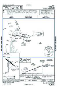
As the plan views for the VOR-A approach into Orange, Massachusetts (KORE), show at right, the FAA/Aeronav version (top) depicts a feeder route from the Gardner VOR/DME to the procedure’s initial approach fix, WETMU, plus a crossing radial from nearby Vortac EEN (Keene, N.H.) as another way to identify the fix. The Jeppesen version of the same procedure (bottom) lacks the feeder route and the cross radial from EEN. The profile view for both versions of the plate (not shown) correctly depict that WETMU is also identified as the 3.5 DME fix on GDM’s 294 radial.
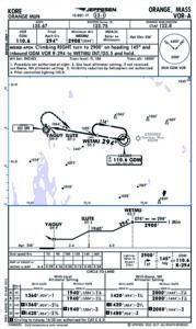
Per a forum discussion on the BeechTalk.com web site, the Jeppesen plan view omits the feeder route from GDM to WETMU and reportedly will be corrected, along with adding the cross radial from EEN, with the next chart revision cycle.
The main point here isn’t that someone made a mistake, but that the two major sources for this aeronautical information presented the same underlying data differently. Another point is that, as this magazine neared its final deadline 10 or so days after the difference was identified, there was no official notification for users. That’s how a lot of charting details seem to resolved when identified, so don’t be surprised by changes..
Special thanks to the knowledgeable and experienced commenters at BeechTalk.com who pointed out these differences and their solution. — J.B.
CORRECTION SECTIONS
In part, that’s because there’s no single repository for updates to aeronautical data. The FAA may issue a Notam when either its underlying data is in error or there was a major chart production mistake. Depending on the chart and the change, a “corrected” publication may not be made available until the next publishing cycle, which for visual charts like sectionals may be up to six months away. At least that’s the way it’s supposed to work.
In the case of visual charts, a typical edition of the FAA Chart Supplement publication, formerly the Airport/Facility Directory, will include pages of corrections to the current product in its Chart Bulletin section. Examples include changed status of military training routes, plotting new obstacles and establishment of new controlled airspace. Changes to the underlying data—a VOR going out of service, an airport closing or a route segment with a new minimum en route altitude—likely will see a Notam, which can apply to all users no matter the chart they use.
Given the shorter 28- or 56-day chart revision cycle for instrument charts, it’s conceivable a Notam may not be published for many situations, with the change incorporated into the next cycle’s chart. When Notams are published, however, usually for an approach procedure but also for arrivals and departures, they often have a material impact on the procedure. But it can take a while to work its way through the system.
For example, the ILS PRM Runway 9L approach at Atlanta’s Hartsfield-Jackson Atlanta International Airport (KATL) as published on February 20, 2020, charts a middle marker. But a Notam published February 28, 2020, advises that the middle marker is out of service permanently. And an earlier Notam, published on January 22, 2020, makes wholesale changes to the procedure, including deletion of various notes and states “delete all reference to MBM MM.” Alas, the procedure published after these Notams came out retains both the deleted notes and the middle marker.

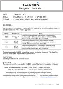
As discussed below in the article’s main text, both Jeppesen and Garmin, as electronic navigation data vendors, have their own systems for alerting users to problems or changes, examples of which are shown at right. Both also offer RSS and updates by email, so you don’t have to go searching out this information each time you fly.
VENDOR VARIFICATIONS
At least we have Notams to work with for these kinds of changes. When it comes to non-FAA charts or the digital data that keeps our advanced avionics up-to-date, the situation may be different—we may have to seek the information from what we might consider non-standard sources.
For example, Jeppesen’s web site has numerous pages devoted to its various information, including electronic and paper charts and its electronic NavData your panel-mounted databases may use. Garmin, which offers similar electronic data for its products, also has pages dedicated to keep users updated on the information’s status as well as an alert system that includes information on those products and their interactions with certain data.
Both Jeppesen and Garmin—and probably other aeronautical data vendors—offer email-based alerts to new information and RSS (Really Simple Syndication) feeds to which users can subscribe. Signing up for email alerts or an RSS feed helps eliminate the error-prone chore of chasing down any new aeronautical data information on their respective web sites. The FAA does basically the same things, by email, through its Aeronautical Information Portal (AIP).
CONCLUSION
There have always been changes to aeronautical data, since Elroy Jeppesen first started writing it all down. The proliferation of electronic data in our cockpits over the last 25 or so years has been nothing short of revolutionary, and today’s avionics can do things unheard of not that long ago. But with the convenience and utility of these new tools comes an even greater and faster way for errors to creep into the data and proliferate throughout the system. To ensure we always have the latest and most accurate data, we may need to take some proactive steps and not wait for the changes to come to us.


Excellent reminder. Before Foreflight i recall the mysterious reappearance of “Fancher Field” on my early 2000’s Seattle sectional. That airport, while the historically important landing site for Clyde Pangborn’s first ever non-stop flight across the Pacific, was decommissioned in the 1960’s or early 1970’s when KEAT (Pangborn Field) was built on the plateau SE of Wenatchee, WA.
Speaking of tiny errors that ‘just happen”: Did the author mean ‘VARIFICATIONS’ or “VERIFICATIONS”?
Verify-“To affirm, substantiate or prove the truth of…”
Varify-“To make different, vary or variagate.”