
A close friend of mine, also a pilot, revels in flying low enough to view various features on the ground, to the extent a long cross-country flight in IMC not only bores him but seemingly can elevate any anxieties. I get it, and always enjoy that vista when I’m able. But I also subscribe to the maxim expressed on one of those humorous “rules of the air” plaques pilot shops often market as gifts for wall-mounting. The “rule” that applies here is the admonition to stay “in the middle of the air,” and not to get too close to its edges.
In this case, “edges” can refer to terrain and structures, where collisions can occur, but also to the limits of the aircraft’s performance envelope. On its face, the “rule” is absurd, but when one thinks about it some more, it’s not a bad way to operate an aircraft. Staying away from the things that can bite us is good policy.
So it is when we might be tempted to fly close to terrain during other than takeoffs and landings. The accident record is littered with tales of pilots who thought buzzing a girlfriend’s house or flying under a bridge was a fine idea, right up to the point it wasn’t. The trick is that even a relatively slow airplane usually is faster than the car we drove to the airport, and flying low and/or close to objects rewards us with a sense of speed that we rarely experience in a car and isn’t present at altitude. Getting close to objects or terrain features and viewing them from the air is something non-pilots can’t do, and for many is one of the reasons they fly.
It should go without saying, however, that the closer we fly to immovable objects or terrain, the riskier the operation. There’s a reason we practice takeoffs and landings, and it’s not just about being able to use the airplane again. Here’s an admittedly extreme example of what can happen when we get up close and personal with terrain.
BACKGROUND
On January 25, 2019, at 1459 Pacific time, a Rockwell International Commander 112A was destroyed when it impacted terrain near the summit of Mount Hood, Ore. The solo private pilot (male, 63) was fatally injured. Visual conditions prevailed at nearby observation sites.
Thanks to his frequent impromptu flights, the pilot’s wife did not report him missing for two days. Using cell phone forensics and an ELT signal, the wreckage was located on the eastern slopes of Mount Hood four days after the accident. Due to the accident site’s nature and the threat of avalanches, detailed on-scene examination could not be performed. The airplane was never recovered.
Fragmented sections of the airplane were spread along a 70-degree slope on the northeast flank of Mount Hood. The first identifiable point of impact was at about 9700 feet msl. Debris and slide marks in the snow extended down toward the main wreckage, which was at about 8700 feet and included the crushed fuselage, fragments of the left wing and the entire right wing. The engine and horizontal stabilizer were about 200 feet below the main wreckage, with the lowest debris located around 8000 feet msl.
An FAA publication, “Tips on Mountain Flying” (FAA-P-8740-60), published in 1999, is a succinct recitation of the various factors that mountainous terrain can impose. It summarizes relevant material from other FAA handbooks and publications. Some highlights related to this accident include:
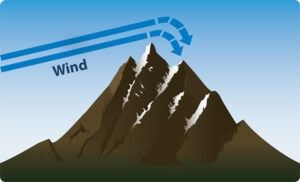
Mountain Waves
“When the wind speed is above about 25 knots and flowing perpendicular to the ridge lines, the air flow can form waves, much like water flowing over rocks in a stream bed. The waves form downwind from the ridge line and will be composed of very strong up and down drafts, plus dangerous rotor action under the crests of the waves. If enough moisture is present, lenticular clouds can form to give a visual indication of the wave action.”
Winds Aloft
“The winds aloft reports are very important to your mountain flight planning process. You should pay close attention to the forecasts at and above the mountain ridges of the terrain you will be flying into. In the west, that usually means the 9,000 and 12,000 foot forecasts. In the east, you will look at lower winds. Winds above 25 knots at these levels should be a warning sign that should cause you to think about delaying your trip.”
INVESTIGATION
Radar data indicate the airplane approached Mount Hood from the north at a Mode C-reported altitude of about 10,000 feet msl. It then followed a counterclockwise, six-mile-wide orbit around the 11,239-foot summit. The airplane then began to get closer to the summit as it rolled out on a westerly heading, turned north for a minute, and then turned back to the west, continuing the orbit. At this time, it had reached its highest altitude of 11,900 feet, about 1.5 miles north of Mount Hood’s summit.
The airplane’s track around the mountain came within about 1500 feet of the summit horizontally as it passed to the west. As it reached the southern face, it began to rapidly descend, with the final two radar targets indicating a vertical speed of about 2500 fpm. The last radar target was recorded at 1459:09, at 9600 feet msl, about 400 feet northwest of the impact location.
The winds aloft forecast for Portland, Ore., about 47 miles northwest of the accident site, projected a northerly flow; 31 knots at 9000 feet msl and 34 knots at 12,000 feet.
More detailed analysis—a Weather Research and Forecasting Model (WRF) simulation—indicated a rapid change in wind speed near the accident site, with speeds ranging from 20 knots to 48 knots over the course of a kilometer. The vertical velocity data indicated that when the airplane was making its first pass south of Mount Hood, the flight path was in a location of updrafts of between 100 and 300 fpm. By the time the airplane made its second, closer pass to the south, the flight path was in a location of downdrafts of greater than 2000 fpm.
Further analysis revealed that, at about the time of the accident, there were rapidly changing updraft and downdraft conditions between 8500 and 14,500 feet directly above and within two kilometers horizontally of Mount Hood.
At its maximum gross weight of 2650 lbs. and with landing gear and flaps retracted, the 112’s rate of climb at 12,000 feet msl with an outside temperature of -4 degrees C, would have been about 220 fpm.
Toxicological testing found levels of oxycodone in the pilot’s blood considered impairing, plus the stimulant modafinil, suggesting the pilot also was attempting to counter fatigue.
PROBABLE CAUSE
The NTSB determined the probable cause(s) of this accident to include: “The pilot’s decision to fly the airplane in close proximity to mountainous terrain in an area of mountain wave activity that exceeded the performance capabilities of the airplane. Contributing to the accident was the pilot’s degraded decision making and performance due to his use of multiple sedating and impairing drugs.”
According to the NTSB, “There was no evidence to suggest that the pilot obtained an official weather briefing before the flight. Had he done so, he would have been made aware of the winds aloft conditions, which indicated the likelihood of terrain-induced turbulence close to the mountain.”
The NTSB added, “Given that multiple drugs involved were sedating or impairing both individually and combined, the pilot would most likely have experienced diminished decision-making ability, increased reaction times, and degraded motor skills. Thus, it is likely that the use of these drugs contributed to the accident.”


