
I started learning to fly at the quaint, waterfront Albert-Whitted Airport in St. Petersburg, Fla., back in the 1980s. It was a great place to fly—beautiful scenery, plenty of options of places to go for practice landings and a reasonably easy airspace set up to facilitate painless statewide cross-country flights. There was one caveat, however. Just across Tampa Bay, off the end of what was then Runway 6, sat MacDill Air Force Base. At the time, MacDill was the home to extensive fighter pilot training, with a constant flow of F-16s doing practice landings or traversing to and from training grounds.
The airspace over the bay buzzed with fighter jets, often akin to the proverbial flies on you-know-what. Thankfully, the jets stayed at or above 1200 feet msl, and we stayed at or below 1000 feet msl. The system worked out pretty well—as long as you played by these rules and, preferably, kept in contact with Tampa Approach. In doing so, one was unlikely to be surprised by an up-close encounter with an F-16. Even when one got used to the arrangement in Tampa, you would occasionally get a friendly reminder via the eerily loud sound of GE turbofans, sometimes with lit afterburners.
RUDE AWAKENING
Dealing with all the military traffic around MacDill was somewhat predictable. However, as soon as the fighters began to disperse across the state and adjacent waters, you never really knew where they had gone or what they were doing. The jets were almost always on a military UHF frequency, keeping us civilians out of the situational awareness loop. There is, however, some rhyme and reason to military flights as they make their way from home bases to training grounds. There are actually set routes that flights typically take, known as military training routes (MTRs).
The purpose of MTRs, according to the Aeronautical Information Manual (AIM), is to conduct “low-altitude, high-speed training. The routes above 1,500 feet AGL are developed to be flown, to the maximum extent possible, under IFR. The routes at 1,500 feet AGL and below are generally developed to be flown under VFR. Generally, MTRs are established below 10,000 feet MSL for operations at speeds in excess of 250 knots.” In short, expect high-speed flights at low altitudes along MTRs.
For the longest time, I didn’t pay much attention to MTRs. Sure, I knew what they were and could point them out on a sectional. But beyond that, I had little understanding of when and how they were used, their dimensions, how to figure out when they were in use and how dangerous they could be. Two experiences changed my nonchalant attitude toward MTRs.
On a drive from St. Petersburg to Vero Beach, the road I was on passed by the north side of the Avon Park bombing range, a notoriously busy training run for those MacDill F-16s. Some cars had pulled over to the side of the road, so I decided to see what was going on—an airshow, one driver said. So I parked to check it out. Just about when I was getting bored waiting for the seemingly nonexistent airshow, two F-16s tore overhead, hugging the terrain and going so fast, we didn’t hear them till they had already passed. They were so loud my ears rang. Apparently, this type of encounter was pretty standard at Avon Park, noted another bystander.
The true smelling salts for MTRs, though, occurred on a cross-country from Albert Whitted to Pahokee on the eastern shore of Lake Okeechobee. It was a typical Florida summer day with cumulus bases around 1500 to 2000 feet agl, so I was stuck getting bounced around below them in my rental VFR-only Cessna 152. Thankfully, I chose to be a responsible student pilot that day and subscribed to flight following with Miami Center. The controller told me I was converging with a “flight of F-16s” northbound, approaching the lake.
The controller recommended I climb at least 200 feet if able. I complied and started to strain my neck, looking for the traffic passing from my right to left. I only noticed them as they flew underneath me—the “flight” was a line of eight F-16s traveling at high speed somewhere in the neighborhood of 800 feet agl. The encounter was alarming enough to raise my heart rate substantially, to say the least. Upon landing, I reviewed the situation. It was then that the light bulb illuminated: these jets were on VR-1087, an MTR that steered them toward the Avon Park restricted area, in which resides the bombing range. Although I had been taught that pilots could cross MTRs without restriction, the AIM warns pilots that “extreme vigilance should be exercised when conducting flight through or near these routes.” Little did I know until then, such an admonition was, in fact, worthy of close attention.
FINDING AN MTR
Unfortunately, MTRs are like those railroad tracks that you cross so often without seeing a train that you almost forget they’re there. It is rare to see them in such high use as they were back during the Cold War days, but they’re still active regularly enough to continue warranting our caution. So how does one identify MTRs and learn the details of these high-speed highways? The typical place most pilots, VFR types at least, might encounter MTRs is on sectional charts. They appear as light gray lines with letter and number codes for identification and arrows pointing in the direction in which traffic is likely to travel. They also appear on FAA low-altitude en route instrument charts as dark brown lines with their applicable label. Note that MTRs do not appear on FAA high-altitude en route charts or as such on Jeppesen IFR charts.
An MTR is categorized as either VR for routes conducted only under VFR only (flight visibility of five miles or more, ceiling greater than 3000 feet agl) or IR for IFR routes on which operations are conducted in all types of weather conditions. The numbering of the MTR also provides insight into its constructs: Those with four numbers are operated with no segment above 1500 feet agl (e.g., IR-1206), and those with one or more segments above 1500 feet agl are denoted with three numbers (e.g., VR-207). Sometimes there are routes with alternate sections which are noted with letters such as “A” and “B” attached to the numerical identifier (e.g., VR-1007B).
While these details are helpful, they do not tell the whole story about the routes. For example, how wide are they? It is often assumed, in many cases incorrectly, that they are narrow like an airway, only a few miles wide. Also, what segments of a three-number MTR are above 1500 feet agl and which ones are not?
The answers to these remaining questions is not exactly easy to determine, especially from sources customarily used by civilian pilots. The place for pilots to go to dig deeper into the details of MTRs is the Department of Defense’s Flight Information Publication (FLIP) Area Planning document specifically on MTRs. This source provides a listing of all MTRs in North America, including dimensions—both horizontal and vertical—as well as hours of operations, who is in charge of it, and other various tidbits of interest. A recent edition of the FLIP document is available online as a PDF at www.daip.jcs.mil/pdf/ap1b.pdf.
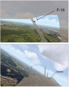
Unfortunately, collisions between military aircraft on MTRs and non-military aircraft do occur, albeit infrequently. One such instance occurred between an F-16 and a Cessna 172 near Tampa, Fla., in November 2000. The F-16 was one of two on a training mission out of Moody Air Force Base in Valdosta, Ga., and was transitioning onto VR-1098. The Cessna had just departed the Sarasota/Bradenton International Airport and was heading north at 1600 feet msl. Both aircraft were in contact with ATC.
Tampa Approach told the Cessna about the two F-16s, but it is unknown if this transmission was received, as there was no response. The Tampa Approach radar system did initiate a conflict alert alarm, but apparently such happens quite often in cases when the conflicts are not of genuine concern. Thus, the controller did not take any particular actions in response.
The trailing F-16 struck the Cessna, destroying it and killing the solo pilot. The jet’s pilot initially recovered, but soon afterward its engine failed and the pilot ejected. The F-16 pilot received only minor injuries.
COMPLICATED DISSECTION
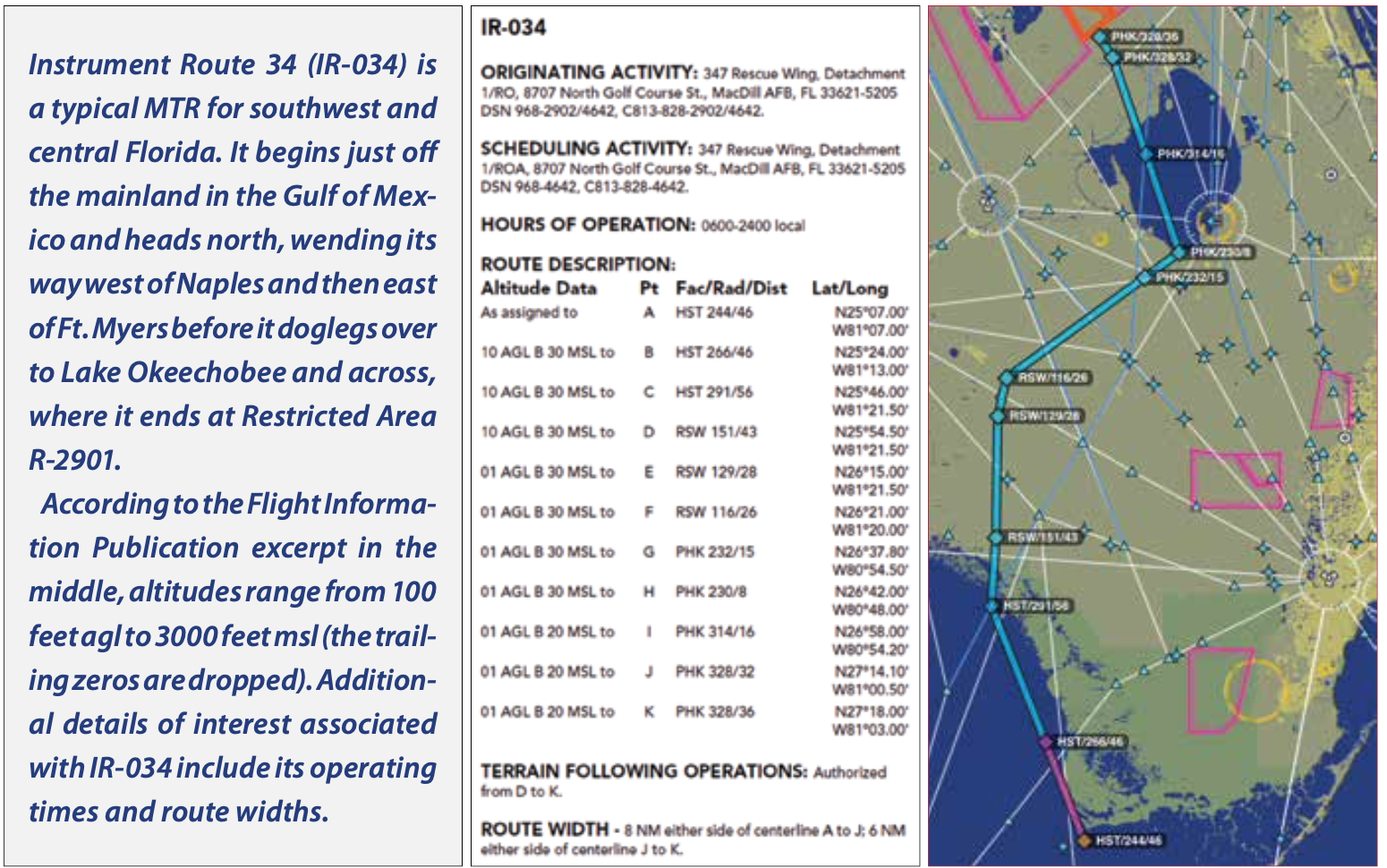
Let’s look at a sample MTR that funnels aircraft into the Avon Park bombing range: IR-034. (The sidebar on the previous page reproduces the FLIP document’s entry for IR-034 and overlays its route on a ForeFlight map.) The MTR has 11 legs defined by latitude and longitude or by facility/radial/distance values. For example, one leg is between a point on the 266-degree azimuth from Homestead ARB (HST) at 46 nm to a point at 291 degrees from HST at 56 nm. On this leg, aircraft may be between 1000 feet agl and 3000 feet msl. The route width on this portion is eight nm on either side of the centerline. On some legs, the width is reduced to six nm, and specific legs allow terrain-following operations, i.e., hugging the ground.
Additional detailed notes are provided, such as how military pilots should avoid the Immokalee and Clewiston airports by at least three nm. They should stay above 1000 feet agl when flying over the Everglades National Park and should avoid buzzing the fishing resort on Route 70 near the Kissimmee River. Hours of operation can span from 0600-2400 local time. Lastly, note that there is a directional arrow pointing up, meaning the MTR is flown from south to north.
Now that you know where to find out more information concerning MTRs, let’s talk about how pilots can deal with these autobahns in the air. According to the AIM, pilots should contact FSS to learn the most current information about routes of concern. When talking to FSS, “pilots should give the FSS their position, route of flight, and destination to reduce frequency congestions and permit the FSS specialist to identify the MTR which could be a factor.”
Some other measures that pilots can take to stay out of trouble include getting VFR flight following and filing IFR, if able. With the former, you may get advisories and information about military activity, but it’s not assured, as such services are not the controller’s primary responsibility.
On the other hand, if you are IFR, the controller will provide separation from other IFR traffic. There still is the possibility of VFR military traffic, but it’s likely the controller is talking to them as well. Regardless of what options you decide to use in minimizing risk, any additional level of precaution and oversight is better than nothing at all. There is a very real possibility that I would not be here to write this article if I had not been getting flight following.
TAKEAWAYS
Hopefully, the takeaways from this article can help you be safer on every flight. Information is vital in aviation, and in the case of MTRs, it seems like data on them is harder to get than it should be. Also, from my experience, there is insufficient attention paid to MTRs in flight training and not much better consideration by general aviation as a whole. Thankfully, encounters between MTR aircraft and non-participating aircraft are few and far between. However, the general aviation aircraft almost always loses out in such encounters, along with its occupants. While MTRs are almost impossible to avoid on most flights, being prepared to deal with them is a critical part of flight planning and execution.
Dave C. Ison, PhD, has over 6000 hours of flight time, holds ATP MEL, commercial SEL/SES certificates and is an instrument and multi-engine flight instructor.


