
(Editor’s Note: This is the second contribution to a multi-part series on going beyond the standard preflight weather briefing to find the details underlying what our EFBs tell us. Look for subsequent installments in future issues.)
The forecast for Monterey, California (KMRY), advertised clear weather for the whole day. This didn’t make any sense, because the airport is right next to Monterey Bay and the ILS approach starts out over the Pacific Ocean. I was visiting pilot friends, and we all looked at the forecast together, agreeing that it was strange. But the forecast said clear and with no alternate required, I didn’t file one.
As I got closer, the ATIS was playing a different tune: Monterey was below minimums. I scanned my IFR chart and tuned in ATIS after ATIS. Everyplace was below minimums. I needed to find someplace to go! Luckily, Monterey’s visibility started to improve, and as I got closer the visibility reached my minimum value. I was able to land from the ILS.
I hate aviation stories that include “Luckily.”
ADS-B
My encounter with Monterey’s weather was in what I call the Bad Old Days, which is any time before we got airborne weather imagery and data services like what is now SiriusXM and ADS-B. These days, if I were in that situation, I could probably pull up a full page of nearby Metars and would have had an easier time deciding where to divert to if Monterey’s weather stayed too low.
But maybe not. What can go wrong?
Equipment
It takes equipment to get all of this wonderful data. Of course, ADS-B Out transmits information about your flight, and is required in most controlled—which, for many pilots, means useful—airspace. More and more airplanes have ADS-B installations; for example, all of the airplanes I rent have both ADS-B In and ADS-B Out. The Out portion is an absolute requirement for the FBO, since the airport is close Portland, Oregon’s Class C airspace.
In computer-speak, the ADS-B receiver is the server; it has the data. A client accesses the data, and for all of the installations I’ve worked with, that means an iPad or other tablet running ForeFlight or some other electronic flight bag (EFB) application. The in-cockpit connection might be Wi-Fi or Bluetooth. Panel-mount equipment like the Garmin G1000 doesn’t need the wireless connection, although in many cases it is available.
Wireless connectivity means that a lot of things have to happen correctly before the data gets to your device. My home router recently decided that it needs to kick me off the network and makes me enter the password again and again and again, and the same thing can happen with airborne devices.
For another example, the ADS-B in one of the airplanes I rent is difficult to pair with any of my devices. Since the pairing requires that the engine be running, this is a costly situation for a renter. So I avoid renting that airplane.
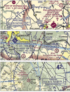
For a fun hangar-flying game, pull out a VFR chart, whether on paper or electronic, put your finger down and try to figure out how to contact Flight Service from that location. Alas, “Flight Watch” on 122.0 isn’t available anymore, so you may really have to dig for it.
But most all FSS frequencies are associated with VORs. The best kind—a so-called “simplex” frequency—just puts the frequency at the top of the VOR legend and the name of the facility below. Near KPUW, for example, you can tune your comm radio to 122.6 and call Seattle Radio with your callsign. (You need the facility name, not the frequency, since some FSSes use the same frequency at many places.) Or you can call Boise Radio on 122.35 from the Lewiston Remote Communications Outlet (RCO). Use the latter if headed into Idaho and the former if headed into Washington.
Some FSS facilities receive on one frequency but transmit on the VOR frequency. This is called “duplex” mode and is indicated by an “R” next to the remote frequency. On my trip to KMRY, I could have called Rancho Murietta Radio on 122.1 but listened over the Panoche VOR’s voice feature on 112.6. Don’t forget to set your audio panel to listen to the nav radio used.
Timeliness
According to the NTSB, it takes time for all that data to make its way into the device on your lap, sometimes as long as 20 minutes for Nexrad radar imagery, and that can be a problem. Never, never, never use Nexrad or other downloaded sources for small-scale (tactical) weather avoidance. Thunderstorms and cumulonimbus clouds move, both horizontally and vertically. Twenty minutes can be a long time, especially when you’re trying to top something that’s growing at 1000 fpm, which may be faster than you can climb.
There are other oddities that come from these devices. It’s not unusual when there are two devices in the cockpit for one of them to have access to data that the other doesn’t. Your device might have the Oakland Metar while mine shows nothing, or the other way around. And you still need to check the time of the observation. It’s not impossible that two devices will have two different versions of the observation. Or there might be data available on the panel mount system that the tablet can’t receive, and vice-versa.
And sometimes there is no data at all, which can be caused by a problem at the National Weather Service or some other link in the data chain. That puts you back in the Bad Old Days. Even calling Flight Service (see sidebar above) might not help in this situation.
The Big Picture
One problem with all of this data is for the pilot to interpret it in a useful way. Interpreting the data uses some of the basic ideas from private pilot training. Why worry about wind correction angles when the devices calculate it for you? In fact, you do not have to dust off the E6-B whiz wheel to calculate the wind correction, but you still need to know that a correction is worked into what your EFB is telling you.
How important is it to read the valid times of a TAF? It might be easier to check this on an EFB, which may color-code it red if it’s of a certain age, but the need to verify that data point has not changed. Some people seem to think that access to so much data would reduce the need for pilots to think. But that’s not the case: The greater amount of data available today, especially in the cockpit, gives pilots better tools for thinking, and more information with which to make a decision.
In looking at weather ahead, you need to note the difference between your heading and your track. You don’t have to use an E6-B for this, but the same ideas apply. If there is any significant wind aloft, your crosswind correction will have you pointed into it, and the weather you want to avoid will appear to be off to one side. That’s what the heading tells you. Your track is a different matter, because your track might be taking you directly toward the weather. This is the same lesson you learned flying the rectangular course early in flight training!
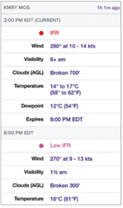
ForeFlight EFB users who want to dive down into more forecasting minutiae have an option: the MOS. According to the company, “Model Output Statistics MOS is an automated weather product that generates forecasts for over 2000 U.S. airports, including many that do not receive official TAFs. Using advanced weather prediction models, MOS forecasts surface wind, visibility, clouds, weather conditions, temperature, and dewpoint, with forecast periods up to 3 days in advance.”
The MOS forecast is subject to limitations, however. According to ForeFlight, “MOS cannot forecast multiple cloud layers as you see in a TAF. Except for when the forecast is shown as clear, a single fixed cloud layer is the best MOS can do. It cannot directly forecast showers in the vicinity (VCSH) or fog in the vicinity (VCFG), nor can it forecast precipitation intensity. Additionally, MOS cannot forecast non-convective LLWS and no significant weather (NSW), both of which can appear in a TAF. MOS is also unable to predict a variable wind and can’t tell the difference between rain and drizzle or mixed precipitation including freezing rain and ice pellets. Currently, MOS only provides domestic forecasts-so you won’t see MOS forecasts for airports outside of the US.”
Finally, ForeFlight also cautions that the MOS is not a substitute for the TAF: “…MOS should never be used for legal requirements such as determining an alternate on an IFR flight plan.” — J.B.
Seeing Is Believing
There is one other thing that is never going to change: Pilots need to look out the window, both for weather and for traffic. Some aircraft aren’t required to have ADS-B or even a transponder; that would still be the case with the Taylorcraft I owned, because it had no engine-driven electrical system. None of your electronic devices would see that aircraft.

Looking out the window is far less complicated and, at least for me, far more fun. The scenery near my new home is great. Since I live under one of KPDX’s arrival routes, I get to see a lot of airplanes. A long line of Airbus 320s and Boeing 737s and Cessna Caravans come over the house headed north; a long line of Citations and PC-12s and King Airs come over the house headed west; and a long line of Cessna 172s and RVs, plus even a Stearman or two, come over the house from wherever. I even saw a 172 doing stalls over the unpopulated area just to my south the other day. It’s busy! Flying through this area absolutely requires looking out the window. It’s irresponsible to keep your head in the cockpit and show off to your passengers how it’s possible to check the weather in Tokyo while flying in this area.
I’m glad the Bad Old Days are behind us all. While these in-cockpit systems aren’t perfect or even 100-percent reliable, pilots now have more information available to make better decisions. But you still have to use your brain to take advantage.
Jim Wolper is an airline transport pilot and retired mathematics professor. He’s also a CFI with single-engine, multi-engine, instrument and glider ratings.


