 scenario copy")
At about 1600 local time, the transient Cherokee 180 pilot requested that his airplane be fueled. The line staff was unable to do so at that time due to heavy rain and lightning nearby. Meanwhile, FBO personnel discussed his plan to take off in poor weather at night. The recently certificated private pilot, heading home after a multi-day business trip, stated he had an international flight scheduled the following day and wanted to leave as soon as possible. After further discussion, the pilot agreed to a hotel room. With the airport gate code, he left in a rental car.
The pilot returned to the airport after the FBO had closed and added 27 gallons of self-service 100LL and departed at 2005 local. The airplane climbed for about 10 minutes, reaching about 7200 feet msl. The final two minutes of the flight included a descent and a series of tight turns before entering a rapidly descending spiral turn. The airplane’s final position was recorded at 2017, about 0.15-mile south of the accident site at an altitude of about 2000 feet msl. The ADS-B data plotted by the NTSB is shown below.
At 2015, recorded weather included visibility of one statute mile; thunderstorms and mist were in the vicinity. The ceiling was broken at 900 feet and overcast at 2600, with distant lightning to the northeast, the direction of flight.
CHEROKEE TWO
The airline transport pilot flew his Cherokee 140 approximately 700 nm to pick up his son and fly home for the holidays. Multiple preflight weather briefings included “VFR not recommended” due to low ceilings and mountain obscuration. Sure enough, the first leg of the trip home ended with a landing in IFR conditions. On the second leg, the aircraft collided with terrain near the peak of a 2700-foot ridge during cruise flight in IMC. The father perished in the crash but the son survived, telling investigators they didn’t file IFR because of a malfunctioning directional gyro.
CHEROKEE THREE
A Cherokee Six 300 was reported overdue on an 82-mile scheduled Part 135 VFR flight in Alaska. No radar or other flight-tracking data were available, but the accident site was located about 35 miles from the departure airport along a direct course to the destination. The pilot and four passengers were killed. The wreckage was distributed along a nearly 400-foot-long debris path. Weather at departure included 1¼ miles of visibility, runway visual range of 2200 feet to better than 6000 feet, unknown precipitation and mist, and an overcast ceiling at 600 feet. The destination airport was IFR or low IFR in the hour after the accident, and the forecast included a 77-percent probability of moderate to severe turbulence en route at 700 feet due to strong vertical wind shear, plus light-to-moderate rime icing conditions in clouds and precipitation.
The commercial pilot was a recent hire by the operator. Company policy required a minimum of two statute miles visibility and a cloud ceiling of at least 500 feet. Pilots also were required to complete a flight risk assessment tool, or FRAT, before each flight, for company approval or disapproval. No FRAT was located and who approved the flight could not be determined.
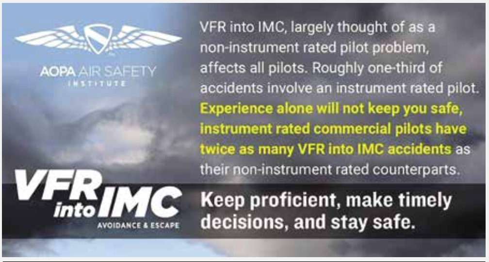
AOPA Air Safety Institute’s review of NTSB reports shows that almost one-third of all VFR into IMC accidents involve an instrument-rated pilot. IFR-rated commercial pilots have twice as many VFR-into-IMC crashes than pilots without an instrument rating, according to AOPA ASI. Why might an IFR-rated pilot get caught flying “visual” in IMC? Common scenarios include an instrument-rated pilot flying under VFR because he/she is:
⎫ Not current for IFR despite holding the rating.
⎫ Not proficient for IFR, realizes it and avoids filing or flying IFR.
⎫ Flying an aircraft not certified for instrument flight.
⎫ Flying an aircraft with inoperative equipment required for IFR.
⎫ Planning to remain out of clouds because of ice or other hazards.
⎫ Avoiding IFR because of a high minimum en route altitude
Remaining VFR is the only option in these cases, but only if the weather permits. Frequently, however, the instrument-rated pilot involved in a VFR-into-IMC accident simply did not file or fly IFR because he/she thought it was more convenient than taking the time to plan and execute an IFR flight. In many such cases the attempted flight is short, and I’d call this scenario “a crash of convenience,” although there is nothing convenient about taking a shortcut only to arrive at this outcome.
COMMONALITIES
The three tragedies are distinct, each with unique causes and contributing factors, but they have several things in common as well, poor weather perhaps being the most obvious. I wonder if the widespread availability of in-cockpit weather is a factor.
Even among experienced pilots, I often find a tendency to minimize flight planning for a VFR flight. The ready availability of weather data updates in the cockpit seems to have ironically made many pilots less dedicated to evaluating weather before takeoff, confident in the ability to pick up additional information in near-real time.
According to NTSB reports of VFR-into-IMC events, the stereotypical blunder into insidiously deteriorating conditions is not the norm. Instead, more accidents involve flying into known IMC with warnings readily available to the pilot before taking off. In all three of these events, they knew there was IMC along the route of flight but went anyway.
LISTEN TO THE VOICES
The ease of self-briefing has largely taken professional evaluation and opinion out of the preflight weather briefing process. Still, often there are others who may offer their opinions and advice. The Cherokee 180 pilot was questioned at the FBO to the point he let them make him a hotel reservation, although he may not ever have checked in. The Cherokee Six pilot violated company policy. The ATP taking his son home from college was advised repeatedly by Flight Service that attempting visual flight was not recommended.
RISK FACTORS
All three tragedies included a pilot seemingly pressured to “go” by outside forces. The first pilot gambled on a last-minute return from his business trip to make an international flight. The charter pilot was new to the job and maybe wanted to show he had what it takes to fly commercially in Alaska. The ATP may have wanted to show his son how it’s done and get him home for the holiday despite a failed directional gyro and instrument conditions.
Making the decision to go tends to make it hard not to keep going.
Meanwhile, it’s easy to read the facts of an attempt to fly visually in IMC and dismiss it as something you’d never do, especially if you hold an instrument rating or if you fly for a living. The NTSB record shows, however, that the rating and professional status alone are not an effective shield against the temptation to ignore warnings and what we see out the windscreen.
VFR FLIGHT PLANNING
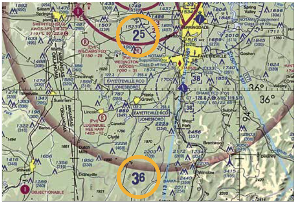
Planning any visual flight beyond the departure airport traffic pattern requires determining a minimum safe altitude for each segment of your trip and ensuring as best as possible you will have at least the minimum required visibility and cloud clearance at the altitude. Altitude planning is easiest because of prominently charted maximum elevation figures (MEFs) on sectional charts.
An MEF is determined by taking the highest of the following: The point of highest terrain within a sectional chart quadrangle, adding 200 feet for obstacles which are not required to be portrayed and then adding 100 feet for vertical error, and then rounding up to the next hundred feet. An alternate method for determining the MEF is to take the height of the highest man-made obstacle in the quadrangle, adding 100 feet for vertical error and then rounding up to the next hundred feet.
The MEF is commonly misinterpreted to be the minimum safe altitude for VFR flight within a quadrangle. In reality, it is the altitude from which to base a minimum safe altitude. For example and as shown above, south of Springdale, Arkansas, the MEF is 2500 feet for a short distance, rising to 3600 feet slightly further south. This means the effective minimum safe VFR cruising altitude—500 feet above those heights—is 3000 msl close in and 4100 msl further south.
For VFR flight in Class E airspace the minimum cloud height is 500 feet higher than that. If you’re flying south out of KASG, your lowest safe cruising altitude is 4100 msl and any clouds must have bases at 4600 msl or higher. To be consistent with the VFR cruising altitudes “hemisphere rule,” you’ll need to be at 4500 or 5500 feet depending on your direction of flight, with the cloud bases no less than 500 feet above that. In your preflight planning, check the MEF for each quadrangle through which you’ll fly, determine the lowest safe altitude consistent with the hemisphere rule, and then check that the en route cloud bases permit VFR separation.
WHAT ABOUT VISIBILITY?
Now that you have the altitude for each segment of your flight, check the anticipated visibility. At the altitudes we’re usually concerned with, the minimum visibility is usually three statute miles (about 2.6 nautical miles).
Whether that should be your minimum visibility is strongly affected by the aircraft you’re flying. In the Cessna 120 I owned many years ago, in still air I could cover this minimum distance in just under two minutes in cruise flight. In the Beech Bonanza I currently fly, 2.6 nm is only about a minute of normal cruise assuming zero winds. I’d want maybe twice the minimum visibility (five miles or better), and even then I’d probably slow down noticeably below normal cruise speed, flying VFR in reduced visibility.
ASK YOURSELF…
Does the forecast and your knowledge of weather patterns give you objective assurance you’ll have the visibility needed at or above the lowest safe altitude in the quadrangle ahead of you? Are you able to maintain VFR cloud clearance requirements at or above the MEF?
These three tragedies, and many others like them, remind us that VFR cross-country flight requires significant preparation and in-flight monitoring, plus an objective evaluation of conditions before and during flight, always comparing them to your capabilities and those of the aircraft you’re flying.
Tom Turner is a CFII-MEI who frequently writes and lectures on aviation safety.


Great article. Looking at the the MEF (Maximum Elevation Figure) for the Arkansas sectional chart quadrangle with the 3,600′ indicated MEF, it shows a high tower on the eastern edge of the quadrangle with a height of 3,415′ MSL. I presume the MEF determination is arrived at using the “alternate method for determining the MEF,” i.e. using the highest man-made obstacle in the quadrangle, adding 100 feet for vertical error and then rounding up to the next hundred feet for 3,600′ (3,415’+100’+round up).
Using the 3,600 MEF, that would mean the actual indicated MEF clearance over this 3,415′ tower is 185′ (around a 5% margin for error). If you were VFR, flying over that tower at 185′, it would be pretty freaky to look straight down at it. Your comment that “…the MEF is commonly misinterpreted to be the minimum safe altitude for VFR flight within a quadrangle” should be printed in underlined, bold, italics. Adding 500′ to the indicated MEF should indeed be considered an absolute minimum to allow for various unintended deviations.
Thanks again!
The reason the “public perception” of GA is awful is all three of the above scenarios. No gyro and lets launch… and this guy is an ATP; if he is that cavalier with his son… imagine you flying with him “up front” and you “in back” in the Airbus.
It is unkind but… you can’t fix stupid. All three are totally avoidable but exercising “due care” and rejecting “get there itis”… wait for better Wx.