
If you’ve been flying for very long, it’s likely there’s a route you frequently use. It could be a quick out-and-back to the nearest $100 hamburger or cheapest avgas, or an hours-long trek to Grandma’s house. It’s something you’ve flown often and know well enough to almost do it without a chart. You understand the topography along the way, where the bolt holes are and how any weather may influence the flight. You may even have a couple of the frequencies memorized, along with expected ATC routings.
I have a few routes meeting that definition. A couple of them are relatively benign in poor weather. The sketchier routes generally involve unforgiving terrain, the kind that can combine with strong winds and/or convective activity to make flying conditions worse than might be expected over flatter areas. The Appalachian Mountains on the east coast and pretty much anything west of Texas meet this criterion.
But the “benign” routes can offer their own challenges. One night, I found a regular route down the east coast populated with “popcorn” showers that needed to be avoided, demanding some broken-field running on my part. Eventually, ATC got tired of watching the slalom course I was running and routed me over Atlanta, which was clear. Although I was quite happy to bob and weave my way over familiar territory, changing my route—or even pulling up short to wait for clearer skies in the morning—was the better choice.
Sometimes, we get so fixated on the planned route that we can forget a simple dogleg will make things easier for everyone. Other times, a 180-degree turn—or not taking off in the first place—are better solutions. Here’s an example of how familiarity with a certain route, perhaps along with a severe case of getthereitis, can result in a less-critical view of adverse conditions than is healthy.
Background
On October 15, 2016, at 1552 Pacific time, a Cessna 182D Skylane impacted a mountain peak near South Lake Tahoe, Calif. The solo private pilot sustained fatal injuries and the airplane was destroyed. Although the flight began in visual weather, instrument conditions prevailed in the area near the accident site. The flight departed Winnemucca, Nev., about 1320, with a planned destination of Jackson, Calif., a distance of 205 nm.
At 1450, about the time the airplane would arrive in a no-wind situation, the pilot sent his wife a text message stating his groundspeed was “79 knots.” Around 15 minutes later, the airplane’s groundspeed had slowed to about 60 knots, according to ATC radar. By 1522, the accident airplane was 12 miles south of Reno, Nev., cruising at around 10,500 feet msl. Over the next 29 minutes, ATC made at least four attempts to contact the pilot but no response was received. Radar data revealed the airplane crossed the western shore of Lake Tahoe (elevation 6229 feet) at 1543, within eight miles of peaks reaching 9983 feet.
It then began veering left and right, with accompanying oscillations in altitude between 10,100 feet and 10,900 feet msl. The last 96 seconds of radar data show the airplane descended from 10,800 feet to the last recorded altitude of 9700 feet about -mile northeast of a 9311-foot summit. Radar contact was lost at 1551. The flight was about 50 miles from its destination airport.
Investigation
Snow, rain and strong wind conditions hampered the search effort. The accident site was discovered three days later, covered in snow, at the 8630-foot elevation and about 3300 feet south of the last radar target. The airplane came to rest on a magnetic heading of about 270 degrees.
The cockpit-area flight control systems were twisted and entangled within the instrument panel. The flap lever was in the stowed, flaps-up position and the fuel tank selector valve was on BOTH. All flight control surfaces were accounted for. The elevator trim actuator was consistent with a five-degree nose-up position. Both propeller blades evidenced being under power at impact.
According to the NTSB, winds at the 700 millibar level (about 9880 feet msl) were from the southwest at around 50 knots. An upper air sounding taken at Reno at 1500 indicated a freezing level at 10,734 feet, with a cloud layer likely near 10,000 feet. The sounding found several layers of clear air turbulence between the surface and 14,000 feet, plus likely mountain wave conditions near 10,000 feet. Weather radar data indicated icing and instrument conditions above 10,000 feet msl for the route of flight around the accident time.
A Sigmet issued for the accident area warned of occasional severe turbulence below 15,000 feet msl while Airmets forecasted moderate icing conditions, with a freezing level between 6000 and 11,000 feet msl, plus instrument conditions and mountain obscuration.
A search of official aviation weather briefing sources revealed the pilot did not contact either source directly for weather information. Although the pilot used an iPad with the ForeFlight app, there was no record of the pilot accessing weather information before the accident flight. The pilot did not hold an instrument rating.
According to his wife, the pilot typically flew the same route six or seven times a year. His mountain flying experience included multiple trips requiring passage over the Trinity Alps, Marble Mountains, the Cascades, and the mountainous terrain of southern California, South Dakota, Wyoming, Montana and Washington.
Probable Cause
The NTSB determined the probable cause(s) of this accident to include: “The noninstrument-rated pilot’s decision to depart on and continue a flight over mountainous terrain into forecast instrument meteorological conditions, icing, and hazardous wind conditions that exceeded the airplanes performance capabilities and resulted in an uncontrolled descent and collision with terrain.”
As with so many other accidents, the real question is “why?” According to the NTSB, “the high wind conditions were apparent to the pilot given the airplane’s slow ground speed.” Additionally, “his familiarity with the area and route, along with the relative close proximity of his destination, may have lulled him into a false sense of security, predisposing him to continue the flight.”
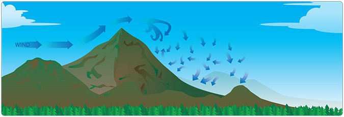
Mountain Waves
The FAA’s FAASTeam, quoting the Colorado Pilot’s Association—who should know—offers these tips for dealing with mountain waves:
• If the winds crossing the mountains are greater than 25 knots, turbulence, updrafts and downdrafts may exceed aircraft limitations.
• Consider crossing mountains only when the ceiling is at least 2000 feet above all ridges and passes along the route, to help reduce exposure to the most hazardous turbulence.
• Good visibility, well above the basic VFR requirements (the FAA suggests at least 10 miles), is necessary since you will generally be using pilotage for navigating.
• Mountain waves generate strong up and down drafts downwind from the ridges. The downdrafts in even moderate mountain waves exceed 1000 fpm.
• Rotors are caused by the wind shear and rotating moment underneath the crest of a mountain wave. The rotors will cause severe or greater turbulence and must be avoided.
AIRCRAFT PROFILE: Cessna Model 182d Skylane | |||
|---|---|---|---|
| Engine | Continental IO-520-BB | Standard Fuel Capacity | 74 gal. |
| Empty Weight | 2195 lbs. | Service Ceiling | 16,600 feet |
| Max Gross TO Weight | 3600 lbs | Range | 697 nm |
| Typical Cruise Speed | 168 KTAS | Vso | 52 KIAS |

