
By Paul Bertorelli
As 2005 draws to a close, we find ourselves well into the age of NEXRAD imagery in the cockpit. For as little as $1000, any Cherokee driver with space on the glareshield can have nearly as much weather avoidance capability as an Airbus plying the flight levels. In some ways, NEXRAD-equipped airplanes have more weather juice than the heavy iron, since they can easily look at weather halfway across the continent, a level of sophistication that still eludes many an airline cockpit.
But the problem with this technology, as a friend of ours likes to say, is that someone might be tempted to actually use it. Thats a cynical way of saying that anybody with a couple of grand and change can wire up a Garmin GPSMAP 396 or a PDA-based AnywhereWx system and go out in play in the weather. Training? Who needs that? After all, how hard could it be to use this stuff?
Fortunately, not very. See where its all purple and red on the screen? Dont go there. Avoiding the yellows not a bad idea, either. But just as familiarity breeds contempt, it also breeds overconfidence, and the companies that sell datalink get a little nervous when they hear customers ask or talk about penetrating weather with datalinked NEXRAD.
Yes, it does make us nervous to hear that, says Mick Gosdin, who heads the highly successful WxWorx program that essentially owns the portable datalink market and is grabbing an increasing share of the panel-mount segment as well. Its not much of a secret that the more of this capability that finds its way into the hands of pilots of marginal skill, the greater the likelihood that someone will push its limits, resulting in just the kind of weather-induced accident NEXRAD is designed to prevent.
Wide Berth
But what are those limits, exactly? NEXRAD is a fabulously capable (and expensive) radar system that has revolutionized the ability to see approaching severe weather. It was designed as both a research tool and a practical means of saving lives by warning people of approaching severe weather in time for them to take shelter. Theres little argument that it has achieved that goal. Having NEXRAD capability in the cockpit is not just a godsend, its a quantum leap in the ability to see weather many miles in the distance.
Its so good, in fact, that the more you use it, the more you think its bulletproof. It isnt. NEXRAD has one significant shortcoming and although its hardly a deadly fault, it has to be understood and accommodated. Its called latency and its the unavoidable characteristic of NEXRAD to display images of weather that are at least five minutes old, but sometimes much older than that.
What that means is that decisions to penetrate weather areas based solely on NEXRAD imagery should be made conservatively if theyre made at all. Its one thing to eyeball a hole in a line with airborne radar-and the skill to use it-but something else entirely to flog through a tight gap based on stale NEXRAD imagery and nothing else.
What exactly is meant by penetration is in eye of the beholder. (We define penetration as flying through clouds near storms using radar-dependent deviation to avoid the worst of it.) I know pilots who will merrily cruise through gaps in a Stormscope strike field that I wouldnt go near in an M-1 tank. Meanwhile, NEXRAD offers so much more data than sferics or even airborne radar that its tempting to trust it implicitly. That trust isnt entirely misplaced. But, as Ronald Reagan famously said, trust but verify; by eyeball, by Stormscope or by ATC radar, when available.
Ive been using the WxWorx XM-based hardware in test mode since the company loaned us a demo unit two years ago. Recently, I flew some trips around weather using Garmins new GPSMAP 396. After skirting dozens of cells with this equipment, I have come to three conclusions: Cockpit NEXRAD is a better strategic tool than a tactical tool; it seems more likely to depict weather worse than it actually is, and it can lure you into flying closer to weather than you otherwise might. Nonetheless, datalinked weather is a huge adjunct to safety and, hands down, it will make it possible to fly trips that you wouldnt fly without it.
Case History
In some ways, NEXRAD has completely changed the rules of severe weather flying. In other ways, nothing has changed. Every pilot applies his or her own rules on using this equipment, but I find I continue to follow the same guidelines Ive always used: When circumnavigating storm areas without airborne weather radar, fly paths that avoid clouds and as much heavy rain as possible. In other words, Im not interested in penetrating weather areas in clouds or heavy rain based solely on NEXRAD data.
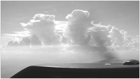
But Ive been tempted. The images on the opposite page summarize a recent trip around Florida. Thunderstorms in Florida are different from those elsewhere. You can count on them firing up every day during the summer, but they rarely form into lines and, although they tend to be lightning-intensive, hail is a rarity. They also tend to be wetter than continental storms and often drown themselves out in 30 minutes or less. But you still have to avoid them and doing so with NEXRAD is much easier than it is without.
Based on my survey of about a dozen other veteran users of datalink NEXRAD, some would shoot a gap like the one described in the opposite sidebar based on NEXRAD alone; some wouldnt. Honestly, I cant say that a decision to penetrate that hole would have been wild-eyed crazy, its just more excitement than Im interested in. In the days before NEXRAD and Stormscope, when we actually thought an ADF could help you navigate around storms, I blundered into a couple of cells by accident. Id rather not do it again, thanks. Remaining clear of clouds as much as possible also means remaining clear of cells. Well, almost.
Too Close
One of the most impressive things about NEXRAD is that if youre deviating visually around a large area of storms, you can reliably see through nooks and crannies and around corners where your eyes wont go. This naturally encourages flying closer to cloud than is necessarily prudent.
On a trip through the Carolinas in July, I encountered an east-west line of severe storms that NEXRAD showed had definite holes. I was deviating toward a big gap, flying in smooth air almost 90 degrees off course and very close to a wall of clouds that probably stretched into the stratosphere. Just as I reminded myself to put some distance between the airplane and those clouds, I hit a patch of turbulence and rain-still in clear air-strong enough to knock the autopilot offline and upset the airplane. I was happy to have visual references to get it upright again in strong turbulence that lasted for 10 minutes.
That brings to mind another thing weve always known: Thunderstorm hazards exist well clear of clouds. Turbulence is one, of course, but the deadlier threats are hail shafts, which can be ejected into clear air outside the storm, and lightning. Thunderstorm researcher Wayne Sand once told me that he and another pilot were flying in clear air near a cell and saw a hail shaft arcing out of the clouds just in time to duck before a hailstone came through the windshield.
Lightning is less of a direct structural hazard but, if you can avoid a strike, why wouldnt you? The Aeronautical Information Manual says that to be completely clear of turbulence, you need to be 20 or 30 miles from a storm; it recommends a 20-mile interval for severe storms. I doubt many pilots with real thunderstorm experience adhere to this conservative advice. Its just not practical, although it inarguably tamps down the risk factor to near zero. In the real world, distance from a storm is calculated on the fly, based on the view out the window, radar, Stormscope, winds and other factors.Although most of us fly much closer than 20 miles, theres no point in flying close enough to a cell to poke a wing into it.
Looks Worse
Our user survey confirmed a phenomenon I have noticed: Datalink NEXRAD seems to make the weather look worse than it actually is. Last summer, I was trying to run around a line of storms in eastern New York state on an August evening, but it was just too intense. I landed and spent the night in a hotel. Improbably, the next morning, the line hadnt moved much. With strong southwesterly flow impacting high terrain, the storms trained for more than 24 hours in the same spot. Late that afternoon, when it finally looked doable, I still had to stick the nose into a broad area that showed solid yellow on the radar. The rain was barely heavy enough to wet the windshield with spots of blue sky and excellent visibility under an 8000-foot ceiling.It was basic VFR. I asked WxWorxs Gosdin about this.
That weather, the heavier rain, was probably above you, Gosdin told me, explaining that the WxWorx version of NEXRAD looks at a cylinder of air from near the surface to the flight levels. Think of a two kilometer column going all the way up, Gosdin says. Thats what the radar is looking at. We take the highest level we see in that column and paint the entire column that color.
I also asked Gosdin about a complaint Ive heard about the WxWorx/XM system, that it relies solely on base reflectivity, a single-scan NEXRAD product that uses the radars lowest antenna angle, at degree above the horizon. The limitations of this imagery are obvious and thats why WxWorx doesnt rely on base reflectivity but uses composite reflectivity which, as he explains, presents an image based on the highest level return found in the scanned column.
At great distances from the antenna, a composite reflectivity scan can overshoot and fail to see a lower precipitation area. But NEXRAD imagery is compiled as a mosaic from overlapping radar sites-thats one reason for latency-and the sites are positioned so a closer radar can fill in the gaps.In theory, overshooting shouldnt cause a rosier weather picture than actually exists.
Conclusion
Back to the original question, is it foolhardly to use NEXRAD to penetrate storms? Theres no pat answer. Like the phrase, theres no such thing as a little ice, lockstep advice to never use NEXRAD for tactical penetration is simply impractical. You have to assess the situation, interpret the NEXRAD and apply whatever other information you have available-Stormscope, airborne radar and your eyeballs-then make a decision.
When datalinked NEXRAD first appeared, we worried that latency would be such an issue as to render it merely the broadest strategic tool. But latency hasnt proved to be as big a worry as we thought. In fact, the reverse seems true. Users tell us that datalinked NEXRAD appears to often paint weather that isnt really there or makes what is there look worse than it is. A wise user shouldnt base a tactical decision on this, but it is the observed trend.
Before getting too jiggy with NEXRAD, fly it awhile and gain some experience. The old rule of never penetrating unless you can remain clear of clouds strikes me as conservative but wise advice. Otherwise, penetrate cloud and rain areas with NEXRAD cautiously if indicated dBZ values are 35 (yellow) or higher. Further, keep track of the time stamp on imagery. If its more than 10 minutes past the current time and youre facing active conditions, tread carefully.
Last, make penetration decisions based on the worst-case information you have. If NEXRAD makes it look bad but a Stormscope doesnt, be cautious. Just because theres no lightning, doesnt mean there wont be serious turbulence.The same advice applies to airborne radar which, despite the advantages of NEXRAD, remains the best close-in tactical tool for thunderstorm avoidance.
Also With This Article
“Flying With NEXRAD”
“User Comments”
“No Single Source”
“Garmins Killer App”
-Paul Bertorelli is editor of Aviation Consumer and editorial director for Aviation Safety.


