
Due to Alaska’s wide-ranging geography and limited road system, residents are heavily dependent upon air travel. In October, the FAA released the final report of its Alaska Aviation Safety Initiative (FAASI), which provides an up-to-date look at the continued problems plaguing the state’s aviation infrastructure. Completed in response to a 2020 recommendation from the NTSB, FAASI was designed to work with stakeholders in Alaska to “review, prioritize and integrate” the state’s safety needs with the FAA’s own processes.
The end result included input from about 100 individuals and organizations, who offered their insight and opinions on problems ranging from poor weather reporting to a lack of IFR routes. While the FAASI recommendations are all largely general in nature and skewed toward continued evaluation, development and study of various concerns, the final report (along with its earlier interim report released in April) is a document well worth reviewing.
Within its 85 pages, which include 40-plus pages of stakeholder comments, readers can learn how antiquated the Alaskan aviation environment is in comparison to the lower 48, and thus gain a deeper understanding of why the accident rate there continues to be so high.
PREVENTABLE ACCIDENTS
Officially, the NTSB’s renewed focus on Part 135 operations in Alaska was sparked by the state’s accident rate, which was 2.35 times higher than the rest of the country. (This statistic is based on figures from 2008 to 2017.) The findings prompted scheduling of the Safety Board’s 2019 roundtable in Anchorage, “Alaska Part 135 Flight Operations: Charting a Safer Course,” which then led to the recommendation establishing the FAASI team. In all likelihood, however, it was several high-profile fatal accidents involving Part 135 operators that contributed to the decision. These crashes, dating back to 2013, include VFR-into-IMC accidents in or near St. Marys, Hoonah, Ketchikan and Hydaburg, a 2019 mid-air collision near Ketchikan, and CFIT (controlled flight into terrain) accidents in Togiak, Talkeetna and Anaktuvuk Pass.
The persistent and preventable nature of accidents involving Part 135 operators in Alaska has long been a source of NTSB concern. (The Board’s published studies on the subject date back to 1980.) The FAASI team acknowledged one obvious solution to the problem in its interim report, stating, “The predominant strategy for reducing Part 135 accidents is to encourage more widespread use of IFR operations….” But action from the FAA, in the form of upgrades to communication, navigation and surveillance equipment, which would enable more widespread IFR usage in the state, has been notoriously slow. As one stakeholder commented in the final report, “Rural Alaska is dependent on aviation. They don’t have the infrastructure equal to the lower 48.” Another was even more succinct, stating, “Infrastructure in Alaska is decades behind the rest of the country.”

The Capstone program, which operated in Alaska from 1999 to 2006, was a “research and development effort” to improve aviation safety that also served as the precursor to deployment of nationwide ADS-B. Funded by the FAA, it included installation and support of necessary ground-based infrastructure as well as GPS avionics for participating FAR Part 135 operators.
Phase I of the program was located in the Yukon-Kuskokwim Delta region and Phase II in southeast Alaska. (Both areas were chosen based on their high accident rates.) There was a Phase III planned, which was to include the rest of the state, but budget issues made that impossible.
The program has been credited with reducing accidents in Alaska by more than 40 percent, but as it is impossible to separate it from other factors that influenced aviation during the Capstone era, including the installation of weather cameras (there are now 230 in the state), and a radical change to the bush mail system, it is impossible to know the program’s specific effectiveness. Capstone definitely ushered in a new era of IFR capability and flight safety for rural Alaska, which Part 135 operators there have been trying to expand ever since.
LACK OF INFRASTRUCTURE
According to the FAASI, 82 percent of Alaskan communities rely on aviation, most of which is conducted under FAR Part 135. Because of this, the report did not consider Part 121 operations, which include not only Alaska Airlines, but also cargo operators and fuel haulers such as Lynden Air Transport, Northern Air Cargo and Everts Air Fuel. In its discussions of fleet composition, the FAASI also does not differentiate between commuter Part 135 operators who provide regular scheduled service carrying passengers, freight and mail, and on-demand charter operations, which more generally operate VFR-only, and are prevalent on a seasonal basis.
The fleet discussion becomes even murkier when the vast array of Part 91 operators are considered. These range from personal aircraft, to those serving clients for hunting and guiding operations, to lodge owners who fly in their customers and to the more idiosyncratic Iditarod Air Force, which comprises a vast array of aircraft types and missions all flying to some degree in support of the annual dog sled race. Essentially, there is no singular operation, Part 91 or Part 135, in Alaska, and broad general statements suggesting otherwise are destined to be quickly dismissed.
As the FAASI team learned in its stakeholder engagements, a lack of usable instrument approaches is a frequent shortcoming listed among Part 135 users of Alaskan airspace. According to the FAA, there are 112 Alaskan airports in the state that do not have instrument approaches. Further, of those Alaskan airports that do have approaches, “many” do not have certified weather observations and thus are not actually usable by Part 135 flights. (The exact number of these airports was not included in the interim or final FAASI reports.) The FAASI team deemed the lack of available weather at these airports a “very high priority for the FAA.”
The reports noted there are currently eight new Automated Weather Observing Systems (AWOS) to be installed and commissioned by September 2022. This will leave Alaska with 141 total automated weather reporting stations, as opposed to about 1800 in the lower 48. The FAASI reports mention the potential for using weather cameras to fulfill the weather reporting requirement at airports, through the development of the Visual Weather Observation System (VWOS). This emerging technology includes 360-degree camera images with sensors that provide winds, temperatures, ceiling, visibility, etc. The technology is currently being tested at four Alaskan airports but is still in the analysis phase. See the sidebar below for more information.
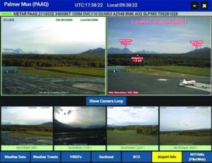
In the “picture is worth a thousand words” category comes the FAA’s Visual Weather Observation System, or VWOS. As this article’s main text explains, the agency plans to expand the program beyond Alaska and locations in Colorado, Hawaii, Michigan, Mississippi and Montana to other states in the Lower 48. A recent post to the Medium.com site by FAA Alaska Region Deputy Regional Administrator Jacki Holzman bills the system as a “low-cost supplement” to existing automated weather observing equipment, which lacks any imaging capability.
According to Holzman, “Sensors attached to existing cameras provide pilots with information including visibility, wind speed and direction, temperature, dew point and air pressure — as well as images from the camera systems.” So far, some 230 camera systems are deployed in Alaska. There’s no word on how many are planned for the Lower 48. — J.B.
ROUTE OBSOLESCENCE
Discussions in the reports on expanding use of instrument flight routes highlighted existing issues with the state’s legacy route structure, some of which dates to the 1950s. According to the FAASI team, current Low Frequency/Medium Frequency airways that have historically supported over 80 percent of the communities in Alaska utilized Non-Directional Beacon (NDB) technology, which is now being decommissioned across the U.S. The demand for low-altitude routes remains strong in Alaska, for both Part 91 and Part 135 users who operate aircraft that must remain clear of icing conditions. The FAASI final report affirmed that satellite-based Area Navigation (RNAV) Terminal Transition Routes (T-routes) are considered the long-term solution to replace the old NDB-dependent routes. Fifty-six T-routes have been developed, although flight inspection on them is not yet complete.
A problem with the T-routes, however, is that although they solve the technology issue with the NDB, they still suffer from the same surveillance and communication gaps Alaskan pilots have always had to contend with. This difficulty is best encapsulated by the following passage from the interim report:
“The Global Navigation Satellite System (GNSS) and Wide Area Augmentation System (WAAS) provides 100 percent coverage for Alaska but communications and surveillance coverage is limited to approximately 50 percent of airspace below 5,000’ MSL. Without future actions by the FAA, the full use of GNSS and WAAS navigation will remain limited.”
Low-level instrument routes already exist in a portion of southeast Alaska, but they are reliant on the Chelton Flight Systems EFIS (electronic flight instrument system) equipment which was provided at no cost to operators who participated in the Capstone program. These “R-routes,” which were established 15 years ago, allowed equipped aircraft to fly IFR at low altitude, often below icing conditions. Stakeholders weighed in on the routes, noting that Chelton is no longer supporting or repairing the company’s EFIS, which has reached the end of its service life. Unfortunately, the Chelton systems are the only ones that were FAA-approved for the R-routes. Thus, as the equipment fails, operators can no longer use the routes. Stakeholders proposed a possible solution involving approval of other equipment so the R-routes could still be used, as they are already in place. Per the final report, the FAA has “initiated outreach” to those operators still using the R-routes, but there is no record of approval for alternate GPS EFIS equipment at this time.
EXPANDING ADS-B
Expansion of ADS-B (Automatic Dependent Surveillance-Broadcast) coverage was also a key point raised by stakeholders. The FAASI team asserted that the FAA does intend to expand ADS-B infrastructure and is working on funding for that effort. As explained in the final report, the areas that presently lack coverage date back to 2007, the period after the Capstone Program ended when ADS-B ground infrastructure deployment and aircraft equipage in Alaska was determined. (The aircraft equipage rate is the percentage of ADS-B equipped aircraft with respect to the total aircraft fleet.) At that time, five of 14 so-called “service volumes” were deemed as not meeting necessary aircraft equipage levels for an adequate positive net benefit to the FAA and industry. They have remained without ADS-B coverage ever since. In 2017, AOPA requested an expansion of ADS-B coverage, specifically in Alaska, and those five previously ignored service volume areas are now the focus of FAA attention.
There were several other topics addressed in the reports, including updating and verifying VFR sectional charts, encouraging usage of the Pirep system and expanding the Aviation Safety Action Program to include smaller operators.
Alaska is a state of superlatives. It covers 586,412 square miles of land, making it one-fifth the size of the entire lower 48 and larger than Texas, California and Montana combined. Its population of 731,545 is the least dense in the country, with 93 square miles per person. The coastline, excluding islands, spans 6630 miles, and five percent of the state is covered in glaciers. There are over 130 volcanos and Denali, which rises 20,310 feet above sea level, is the highest mountain in North America.
As of December 2020, the FAA counted 396 public-use airports—of which 284 are land-based—four heliports and 108 seaplane bases (the most in the country). There are also approximately 763 “recorded landing areas.” In Anchorage, Ted Stevens International is the fourth largest cargo airport in the world and nearby Lake Hood, the only seaplane base with primary airport status in the U.S., is the largest and busiest seaplane base in the world. Based on a 2016 FAA fact sheet, there were 7933 active pilots and 9346 registered aircraft in the state.
WHAT’S NEXT?
In its 11 recommendations to the FAA Administrator, the FAASI final report relied upon general buzzwords to emphasize future actions for the agency. The phrases included “continued…focus,” “conduct a study,” “seek funding,” “evaluate,” “develop strategies” and “continue its efforts.” There were few specific plans beyond the installation of the eight AWOS units and future meetings with various working groups. Under its “Next Steps” section, the report states that FAASI’s focus will be on reducing accidents and “increasing system efficiency.” These goals will be accomplished by expanding the group working on the initiative and establishment of a “tiger” team that will meet early in 2022. It is scheduled to issue a progress report no later than September.
The FAASI interim and final reports are free for the download from the FAA’s web site at www.faa.gov/alaska.
Colleen Mondor is a private pilot with degrees in Aviation Management, History and Northern Studies. She has written about, and worked in, Alaska aviation for 25-plus years.


