
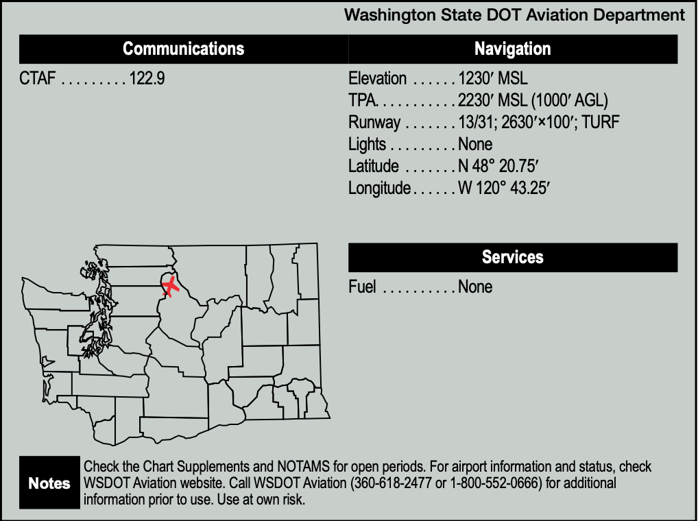
The day started out with perfect July flying weather in Washington State. I convinced my girlfriend to fly with me to Stehekin State Airport (6S9), located at the end of the beautiful, 50-mile-long Lake Chelan, where millions of years ago, glaciers scooped out the valley. I was well-prepared for the flight and even put a life vest on my friend before we departed. I knew there were available bicycles at the landing strip, so I looked forward to riding through the beautiful Douglas fir forest, across a bridge over the Stehekin River to Rainbow Falls and then to the famous Stehekin Bakery. I had flown there three times before, so I felt confident, especially after recently practicing my short- and soft-field landings. I remembered to pack the emergency beacon, bear spray and snacks.
OUR LADY OF MAGENTA LINES
Stehekin’s dirt strip can be difficult to locate, since it is sandwiched in between Douglas fir trees over 100 feet tall and wedged behind a cliff at the end of the runway. The plan was to fly slow and low for the short/soft-field landing. In addition to my memory, I had my Garmin GNS 430 with its magenta line to lead me to the airport.
For this flight, I configured the 430 to show the colored terrain awareness page, instead of the usual nav page with its black background. As I flew low and slow over the big trees on the approach, I paid less attention to the GPS and more to the trees, and dealing with mountain valley gusts. I was confident I knew where the airport was.
On what I thought was final approach, I flew right past the airport without seeing it, flying low and parallel to the runway about 100 feet above the tall trees. With the terrain awareness map selected, the magenta line should have led me to the airport. That was the plan, anyway. However, due to red, yellow and black dominating the screen, I did not notice that the magenta line had completely disappeared!
Unfortunately, I was now following the black line aligned with the river in the bottom of the valley. As I flew a bit further, I questioned my memory since I had not remembered the terrain rising as rapidly as it did. Nevertheless, I continued flying up the left side of the valley looking for the airport, with rising vertical rock walls on both sides of the airplane.
MOUNTAIN TURN!
Suddenly the valley narrowed from about a half-mile to about one-tenth of a mile. I knew that I somehow missed the airport and now I looked nervously for a place to make a mountain U-turn. The valley quickly turned right so I also turned right, and then immediately I was staring at a rising vertical cliff dead ahead with the valley walls left and right closing in. I needed to execute an immediate U-turn but felt it was 50/50 that I could make it.
I looked at the cliff ahead, added full power, 20 degrees of flaps and pitched up to a VX climb. To my relief, I noticed the edge of the cliff appeared to be moving downward in the windscreen, so I was now hopeful that the plane would make it over the cliff. Once over the cliff, the valley opened up to about 1/8 mile, and I executed a textbook mountain U-turn and flew back down the valley.
The airstrip was clearly visible when we flew back at a higher altitude over the trees, and I said that wanted to land, but my girlfriend made it clear to me that landing there now was a firm no. Instead, we returned by flying down the beautiful lake, with a great view the snowfields on the upper peaks. We changed our destination to Chelan, Washington (S10), where we enjoyed the pilot-friendly airport at the edge of Lake Chelan.
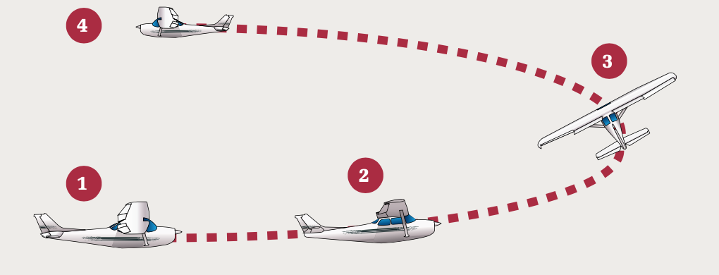
The so-called box-canyon or mountain U-turn maneuver is very similar to the chandelle performed for the commercial certificate. The major difference is it’s flown more slowly, to minimize the turn radius. Here’s how:
1. Snug up as close as feasible to the side of the canyon opposite your planned turn direction. After slowing, deploy approximately half flaps—you want additional lift but minimal additional drag.
2. Roll into a 45-degree bank and add full power. Pull the nose up for additional clearance and deceleration, but not enough to stall.
3. Maintain that attitude through at least 90 degrees of turn.
4. Once course reversal and terrain clearance is assured, lower the nose to accelerate and clean up the airplane. Practice makes perfect. — J.B.
LESSONS LEARNED
Of course, I learned a few things. First, when approaching an airport totally hidden by trees, in addition to using the radio, always overfly your airport to look for wildlife, other aircraft and to verify its location! Second, keep your avionics display simple and uncluttered to be sure you stay precisely on the magenta line. I would have done much better without the terrain page when trying to locate the airport. Third, if you think you might be starting to fly up a mountain valley with rising terrain, strongly reconsider turning around immediately, before the valley rises and gets too narrow. Fourth, never fly in mountain valleys unless you have been trained on how to safely execute an emergency mountain U-turn. Fifth, be sure to calculate the density altitude, your aircraft’s total weight, runway performance and reserve horsepower for the unexpected. Last but not least, if you have a passenger with a fear of flying, you may wish to reconsider your destination!


