
One of the riskiest everyday operations pilots are likely to encounter is an instrument takeoff and departure into relatively low clouds. The increased risk comes from the takeoff itself—we’re never really sure the airplane will fly until we try it—and the much smaller margin for any error that being close to the ground in IMC always presents. Importantly, risk also comes from the pilot suddenly being immersed in instrument conditions when they were flying just fine visually a few moments before.
It’s also a busy time for the pilot. We’re concentrating on managing the airplane but also are retracting landing gear and flaps, complying with a clearance’s altitude and heading constraints, monitoring airplane performance and confirming it’s as we expect.
No matter how ready we think we are to control the airplane by reference to the flight instruments only, it can take time for us to abandon all hope of a visual horizon and actually buckle down to methodically scan the instruments and make needed adjustments to the airplane’s state and trajectory. Too, we can be subject to the somatogravic illusions caused by changes in linear accelerations and decelerations, or in G forces.
One way to minimize these risks, of course, is to not take off into such conditions. While that’s a practical way to mitigate the challenges for some, it’s very impractical for many other operators. The preferred method is by attaining and maintaining proficiency in the operation. That requires practice, something many of us don’t have time for, or manage to rationalize away. That practice, though, is about more than merely controlling the airplane. It’s also about experiencing the acceleration and G forces, knowing how they might affect our perception of the airplane’s performance and compensating appropriately. If we don’t, the outcome can be spatial disorientation and a smoking hole in the ground.
BACKGROUND
On July 13, 2021, at about 1042 Pacific time (PDT), a Cessna 421C Golden Eagle III was destroyed when it collided with terrain shortly after takeoff from Monterey, California. The pilot (61, female) and passenger were fatally injured. A marine layer prompted an IFR clearance to VFR on top.
The airplane departed Runway 10R at 1738:44, and the pilot checked in with Oakland Center as it climbed through 1700 feet msl. The controller saw the airplane was turning the wrong way and issued an immediate right turn to a heading of 030 degrees, which was acknowledged by the pilot. The airplane continued climbing in a right turn, reaching 2000 feet before a descent began. The controller then immediately issued two low altitude alerts with no response from the pilot. No further communication from the pilot was received. Automatic dependent surveillance-broadcast (ADS-B) data was lost at 1740:38, at 775 feet msl and about 520 feet southwest of the accident site.
A witness reported observing the accident airplane descend below the cloud layer in a nose-low attitude with its landing gear retracted. The airplane made a right descending turn and impacted the top of a pine tree before descending out of sight, followed by the sound of an explosion.
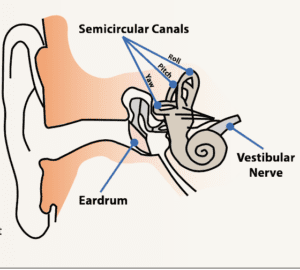
The FAA Civil Aeromedical Institute’s publication, Introduction to Aviation Physiology, defines spatial disorientation as a “loss of proper bearings; state of mental confusion as to position, location, or movement relative to the position of the earth.” According to the NTSB, “Factors contributing to spatial disorientation include changes in acceleration, flight in IFR conditions, frequent transfer between visual flight rules and IFR conditions, and unperceived changes in aircraft attitude.”
The FAA’s Airplane Flying Handbook (FAA-H-8083-3B) adds, “The vestibular sense (motion sensing by the inner ear) in particular can and will confuse the pilot. Because of inertia, the sensory areas of the inner ear cannot detect slight changes in airplane attitude, nor can they accurately sense attitude changes that occur at a uniform rate over a period of time.”
INVESTIGATION
The first identifiable point of contact (FIPC) was 405 feet from the main wreckage, oriented on a heading of about 067 degrees. Various portions of wing skin, right wing, flap, aileron, engine, propeller blades and propeller hub were observed throughout the debris path. The fuselage came to rest upright against a residential structure.
Weather at the departure airport, at 1054, included visibility of nine statute miles under an 800-foot overcast. A sounding near the accident site supported cloudy conditions from about 1100 to 1700 feet msl with a freezing level at about 17,000 feet. The wind below 2000 feet was from the west at less than 10 knots. A temperature inversion was noted between 1600 and 4600 feet. An earlier pilot report stated cloud tops were near 2000 feet msl with bases at about 800 feet.
In the 12 months preceding the accident flight, the pilot accumulated about 0.3 hours of simulated instrument flight and 0.7 hours of actual instrument flight but logged no instrument approaches.
Examination of the wreckage revealed the fuselage was mostly destroyed by thermal and impact damage. Flight control continuity could not be established due to multiple separations, plus impact and thermal damage. All areas of separation were consistent with overload or were cut by recovery personnel.
All components throughout the airplane exhibited severe thermal and impact damage, except portions of the empennage and the right wing. Multiple instruments were separated from the instrument panel. One heavily damaged gyro instrument exhibited rotational scoring.
Both wings had separated at their respective roots, and were highly fragmented, including the main landing gear. Both engines had separated from their mounts and exhibited significant impact damage. All six propeller blades exhibited some combination of bending, polishing of the blade face and/or unidirectional striations on the cambered side of the blade. Examination of the airframe and engines did not reveal any anomalies that would have precluded normal operation.
PROBABLE CAUSE
The NTSB determined the probable cause(s) of this accident to include: “The pilot’s failure to maintain airplane control due to spatial disorientation during an instrument departure procedure in instrument meteorological conditions which resulted in a collision with terrain. Contributing to the accident was the pilot’s lack of recent instrument flying experience.”
Summing up, the NTSB stated, “The airplane’s climbing right turn occurred shortly after the airplane entered IMC while the pilot was acknowledging a frequency change, contacting the next controller and acknowledging the heading instruction. Review of the pilot’s logbook showed that the pilot had not met the instrument currency requirements and was likely not proficient at controlling the airplane on instruments. The pilot’s lack of recent experience operating in IMC combined with a momentary diversion of attention to manage the radio may have contributed to the development of spatial disorientation, resulting in a loss of airplane control.” We’d replace the words “may have” above with “likely.”

