
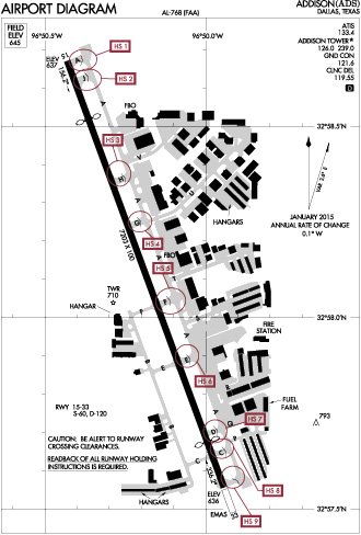
The FAA defines a hot spot as a location on an airport movement area that demands heightened attention by pilots and vehicle operators due to the history of potential collision or runway incursion. Knowing where any hot spots are at the airports you intend to use arms you with useful risk management information. Meanwhile, the FAA has gone sort of nuts with the airport hot spot concept. Don’t believe me? Check out the airport diagram for Addison Airport (KADS) in Dallas, Texas, below. Every taxiway intersection east of the runway is a hot spot.
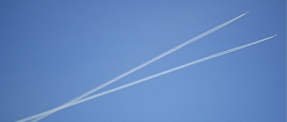
But what about airborne hot spots, those locations where a mid-air collision is more likely, or has happened more than once? Aren’t close encounters in the actual skies something to be as mindful of as those on the ground? There are clearly places in the U.S. airspace system, especially places with concentrated air traffic, that require heightened risk management. The FAA doesn’t have a specific program for identifying mid-air hot spots, but we can use logic and draw from experience to find where they occur and plan accordingly.
Airports—Duh!
Every sectional chart also shows myriads of mid-air hot spots. They are called airports. Just as every single taxiway intersection at Addison is a hot spot, any time your cross-country flight path takes you near an airport, there is a reasonable chance there will be airplanes in the vicinity of your flight path. If you are at 5000 feet agl with an airport five miles abeam, there is a decent chance an airplane that is coming from or going to the airport will be near your flight path.
Not all airports are really hot spots, just as not all airport runway intersections are hot spots, despite Addison’s example. But some airports are definitely busier than others and so have greater potential for greater risk. Some factors to weigh are: Is there a large flight school? Parachute operations? Business jet traffic? Are there seasonal cycles that might affect operations (crop dusting, for example)? Is it the fire season near an active fire base? These are the details to consider when planning your route around airports. On long trips, it is always good to monitor the CTAF at airports you cross. Since adjacent airports often have different CTAF frequencies, you have to pay attention so you can avoid inadvertently sneaking up on a potentially busy facility.
When planning a cross-country flight, you can use a bit of logic to build a mental probability field to determine where traffic might intersect your route. For example, if the airport is near a major city airport, there is a high probability there will be more traffic to and from the larger city airports to smaller outlying airports. Similarly, if an airport is on a major pathway between two larger cities, you can count on greater traffic along that corridor.
Whenever you see victor airways and major highways aligning, there likely will be more traffic along that corridor. When an adjacent airport’s departure or arrival path crosses that “highway in the sky” connecting major cities, it matches my criteria for a mid-air hot spot. For this reason, airports adjacent to victor airways represent greater potential for mid-air hot spots than airports simply in the middle of nowhere.
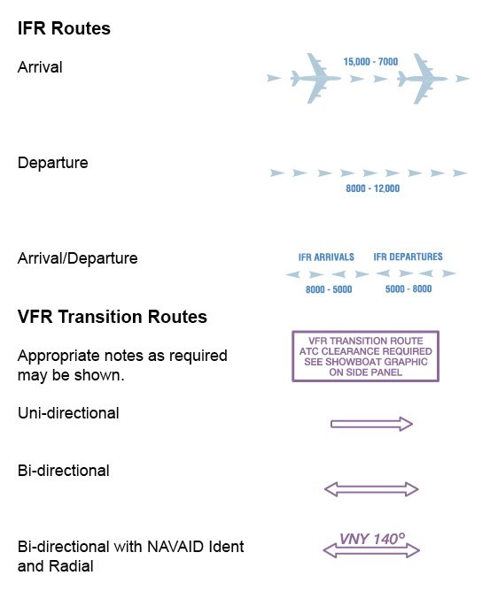
VFR Transition Corridors
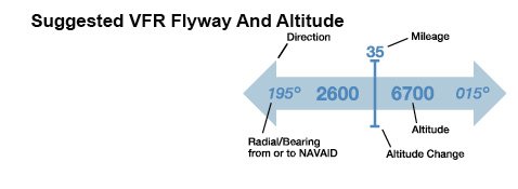
Most Class Bravo airspace has a set of VFR corridors that concentrate traffic into manageable areas that deliberately avoid the busy approach and departure paths. These corridors often recommend directional altitudes for separation, as depicted in the chart legend excerpts on page 13. The good thing about transition routes is ATC assistance is usually available to help you navigate the hot spot and avoid other traffic.
When VFR flight following is not available, however, you will just have to keep your head on a swivel and your eyes outside the cockpit. You may be tempted to look down at your iPad or another device to keep from busting airspace in these busy areas, but the reason for controlled airspace as is to keep you separated from traffic. If your gadget is equipped with ADS-B In and provides traffic, remember that not all traffic will be displayed. You’ll ensure traffic separation with your see-and-avoid eyeball skills, not your gadget-and-moving-map skills.
High-Activity Areas
Nearly every pilot has been to the local practice area near their homedrome for a flight review or perhaps training for a new rating. I always thought the concept of practice areas was a bit ironic: “Let’s find some airspace that is safe because it isn’t busy and then concentrate student pilots there, thereby making it busy.”
Some operations that constitute mid-air hot spots have their own icons on VFR sectionals, excerpts from which are on the opposite page. Skydiving operations usually are coordinated with ATC. If you are near an airport with skydiving operations, you should monitor ATC and CTAF near these airports to help you stay apprised.
Glider operations are a bit more complicated. Airports located near good gliding conditions usually have specific busy seasons. If you know it is gliding season, watch for concentrations of gliders near ridges. If there are cumulus clouds nearby, the areas below them are often connected to the updraft zones of thermal lift, which attract glider pilots like ants at a picnic. If you see one, there may be many others.
Meanwhile, there are scenic locations and destinations all over the U.S. that attract airborne gawkers, with increased traffic and risks resulting. This risk (and environmental concerns) resulted in special rules for operations over the Grand Canyon, and many other attractions (e.g., Niagara Falls) have special published procedures designed to separate traffic. Many other aviation tourism routes are codified and known only to locals: San Francisco’s “Bay Tour” is known to local pilots and ATC, but there’s no published charting or procedures.
Some airports have more jet traffic than others. For example, Sun Valley, Idaho, is known for its business jets almost as much as for its skiing and scenery. Jets descending from the flight levels to land to the north at KSUN commonly pass across the E-W airway at PRESN on V500, usually at altitudes ranging between 10,000 and 16,000, common altitudes we GA types fly in that area. The good news is the jets are talking to ATC, but they are also much faster than us so closing rates are exceptional.
Terrain Bottlenecks
As a commercial mountain pilot, I regularly fly over mountain passes and into busy canyons. Terrain features like these funnel aircraft into corridors usually below 3000 feet agl. Local customs, with some assistance by the Idaho Division of Aeronautics, have resulted in some best practices to minimize conflicts.
The first of these was instituted decades ago and passed along by mountain flying instructors: When traveling in a river canyon, keep to the right side of the canyon. Like the hemispheric rule separates aircraft vertically, the right side of the canyon rule keeps oncoming traffic on the opposite side of the canyon. This is pretty natural because it is like driving on the right side of the road.
Mountain passes and low divides between drainages also concentrate aircraft. Sectional charts show mountain passes by name, which helps pilots easily identify the low spot but also is useful for position reports. A report like “five miles east of Monarch Pass” lets other pilots know where you are.
If your cross-country trip crosses a divide and you intend to squeeze through a pass to avoid a climb, you aren’t the first pilot to make such a plan. Others might also be heading to that low gap, or you might be nose-to-nose with someone headed your way from the other side. There’s also a good chance no one is flying the hemispheric rule since you are likely below 3000 feet agl. For this reason, it’s a good idea to make a radio call on a general frequency like 122.9 or even the CTAF of the nearest airport.
Airspace Constraints
Prohibited areas, restricted areas, the DC SFRA, Bravo airspace and TFRs all have one thing in common: they concentrate aircraft along their borders. When these airspace types butt up around features like mountain ranges or busy airports, you have a formula for conflict.
If you are leaving Southern California to the northwest, one way out is through Owens Valley along the eastern flank of the Sierras, where avoiding the restricted area for China Lake pushes you against the mountains. You will have a narrow gap between the Sierras to your left and the restricted airspace to your right, it’s a good place to be on the lookout for other traffic.
Plan and Think
Because speeds in the air are much faster than those on the ground, mid-air hot spots are much larger and more difficult to depict on a map. Additionally, mid-air hot spots have lateral and vertical dimensions. The FAA does have publications depicting mid-air hot spots—the sectional chart—but not every location makes the cut for inclusion. With a little lateral thinking, it is also the key you should use to create a mental map of a probability field: locations where you there is a greater likelihood of encountering other aircraft.
Next time you plan a flight into airspace with which you are less familiar, plan and think where you might encounter aircraft along the way. If you are going somewhere considered a tourist area, ask the local FBOs or CFIs about traffic flows. Are there any unpublished procedures?
If you are a map enthusiast, consider highlighting or circling potential hot spots on your sectional. If you using an EFB and it offers markup features, use them to mark where you think there are mid-air hot spots area with an eyeball as a reminder. When you get to those locations, use your radio as well as traffic displays to maintain and enhance situational awareness while keeping your eyes outside the cockpit. Mid-air hot spots exist, but it is up to you as PIC to know where to find them. It isn’t that hard, but it is just one more thing you should pay attention to.
Alan Wilson
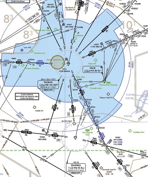
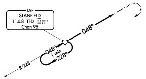
The Stanfield Stack
Phoenix, Ariz., is home to several major flight-training operations, mostly for international students who need practice shooting ILS and RNAV approaches from a hold over a VOR. The Stanfield VOR (TFD) south of Phoenix (circled in red) is a great place for IFR students to do practice approaches into nearby uncontrolled Casa Grande (KCGZ) airport, one the nearest locations outside of Class B. For the RNAV and ILS approaches to Runway 5, the plate excerpt (inset) shows a one-minute hold over the VOR, the minimum altitude for which is 3500 feet msl.
VOR distribution and The MON
Not all VORs are the same level of busy. Some are there for regional navigation while others feed IFR traffic to/from major airports. A VOR near an airport with significant training activity becomes a magnet for student pilots. If your route crosses over a VOR, these are all factors to weigh. If there is a published hold at the navaid, maybe you should consider passing slightly to the side to avoid the concentration of airplanes. In some places with larger schools, you might want to avoid the VOR altogether (See the sidebar on the “Stanfield Stack,” below.)
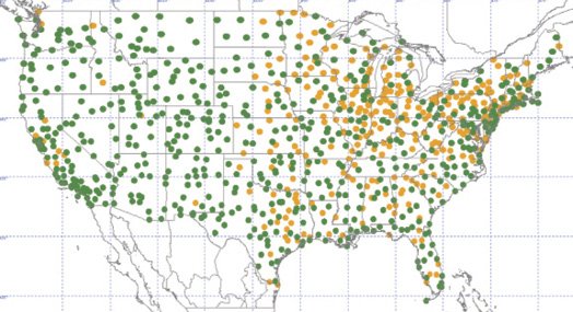
Meanwhile, the FAA is engaged in an effort to decommission VORs that acknowledges satellite-based navigation but also ensures adequate navaid coverage in case of widespread GPS outage. It’s called the Minimum Operational Network (MON) program, and the agency says approximately 30 percent of the existing VOR network is slated for decommissioning. Above, candidates are shown in orange, with VORs to be retained in green.
Orthogonal Crossing Corridors
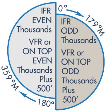
The cruising altitudes identified in FAR 91.159 (the “hemispheric rule”) and presented graphically at right do a good job of separating traffic flying an east-west course. In contrast, north-south routes can be a bit sketchy. In the spots where air traffic corridors involve north-south traffic crossing east-west routes, it is wise to be on the lookout.
The hemispheric rule in the U.S. dictates that flights above 3000 feet agl and below 18,000 msl choose a cruising altitude thusly:
• On a magnetic course of 0-179 degrees, fly at an odd thousand-foot msl altitude, plus 500 feet (e.g., 3500, 5500 or 7500 feet msl when the course is easterly) or
• On a magnetic course of 180-359 degrees, use an even thousand-foot msl altitude, plus 500 feet (e.g., 4500, 6500 or 8500 feet when the course is westerly).
When you are preflight planning, look for the obvious crossing points along your route and fly defensively.
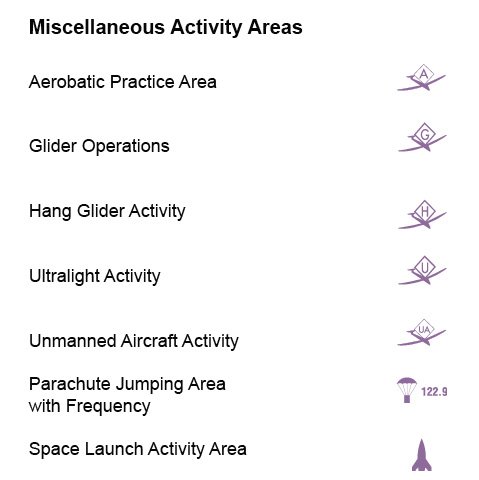
When it comes to charting known airborne hot spots, the FAA’s VFR publications do a pretty good job. The legend excerpts above include some of the ways this is done, and what these symbols mean. Ideally, your flight planning will discover these hot spots before you stumble into them.
Mike Hart is an Idaho-based passenger, cargo and backcountry pilot. He also is the Idaho liaison to the Recreational Aviation Foundation.


Hi Mike. Great article. I came across this because I have just finished a project called HotZones (www.hotzonesfly.com) which I think you’d like. It infers high traffic areas from historic adsb returns and will score it in garmin pilot and foreflight
Check it out and let me know what you think
Cheers
Warren Burch