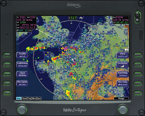
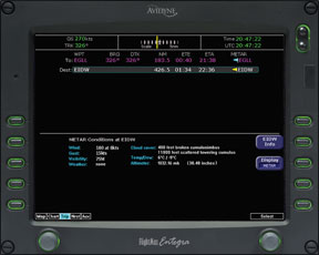
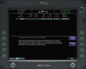
If youve flown much in front of a Garmin G1000 or Avidyne system equipped with datalinked weather, you know they can deliver nearly as much information as an FSS briefing or a Duat session. While datalink weather was never intended to substitute for a full weather briefing, the reality is many pilots use it that way. But does it substitute for a full-up weather briefing, practically or legally? The answer to the first question is “maybe,” but to the second, its a fuzzy “no.” Still, getting 288 your weather brief literally “on the fly” in the cockpit can save a bunch of time. If the route is familiar and conditions relatively mild, the only thing youll miss is the FSS briefers closing plea for Pireps. Putting all your briefing eggs in that single basket, however, raises some questions. Namely, are there any critical things youll miss by substituting datalink for FSS or an online source? In many circumstances, datalink can provide more than enough information to complete a trip safely, but when the weather is really the go/no-go top line item, youre going to need information that your onboard datalink might not provide. Context is Everything Lets take a benign example: a short wintertime flight in the desert Southwest U.S. Its clear and a million, theres obviously no weather around and-given the domestic forecast-none is likely. Where to start the datalink-based briefing? The natural starting place is a look at the big weather picture: Pull up the Nexrad pages. Although XM WX Data and WSI InFlight process their raw radar data a little differently, the big picture will be same: Either theres precip on the display or there isnt. If there is, you can examine the risk more thoroughly using other datalink products or cut your losses and seek a fuller briefing from FSS or other sources. Convective weather isnt the only weather hazard, of course, but its the one most of us look for first. The bottom line? Nexrad is likely the most powerful tool in the datalink toolbox and is the first go-to product. In many cases, it will suffice. But in active weather, youll want more information before launching, if you launch at all. And an online service is better for that. Whats next? Probably cloud cover and visibility. Here, the datalink weather systems shine because both XM and WSI provide graphical Metars. WSI sets up its Metars in what it calls “high-glance value,” meaning you can tell at glance what the weather at each station is doing. The legend is simple: blue for VFR, green for marginal VFR, yellow for IFR and red for low IFR. Its all logical enough. On a benign day with all blue flags everywhere, you might skip that detailed review. If surface wind will be a factor, say on a post-frontal day, thats something worth checking. When the weather is seriously down the tubes, plodding through Metars on a datalink screen is slow. Its more efficient to call up the list you want from a Web source and scan the conditions in 288 column format or maybe even print them out. Having them read by an FSS briefer, while adequate, is also slow going. Datalink has all the Metar information you could ever want and, while its relatively accessible, stroking a fixed display or a portable navigator to get it might be tedious. So its a good tool when the weather is tame, but not so good when things are marginal or bad. Trends Even as Metars show current weather, their prognostic terminal area forecast (TAF) cousins project 24-hour forecasts for weather within six miles of the airport. If the weather is stable, TAFs are still worth checking and are easy to scan in datalink formats. The length of a TAF might tell you as much as its details. A series of four single-line TAFs suggest not much is happening, but when they run to multiple lines, a closer look is warranted. To put TAFs in context, youll need some sense of what the weather makers are. Is there a front charging across your intended route of flight or is there a large high parked over it? Here, datalink weather is weak because it doesnt offer much depth in depicting overall surface features. The surface analysis maps show location of major weather features, but with minimal detail and only for a single time period. By contrast, online sources offer prog charts to show developing trends in the near and longer-term future. We should know an occluded front when we see one, and what happens when flying through or near frontal weather. We also know weather travels in lows. High pressure is good, low pressure is not, and the datalink shows us all the above. In dynamic weather, a datalink-only briefing will be thin on information and may not serve as the primary weather data source. An online or FSS briefing is the better choice. In benign or marginal weather, datalink will suffice. Hazards All of the weather services and datalinks provide special products for weather hazards, including Airmets, Sigmets, Center Weather Advisories and freezing levels. These are useful 288 red flags that will warn you to look into conditions more carefully. In addition, datalink services provide other hazard warnings based on domestic weather products, such as XMs county warnings and severe storm tracks. Whether these are useful or not depends on how much weather data you like to have in a briefing-regardless of where it comes from-and what the weather is doing. Most experienced pilots, for instance, will use an Airmet as the trigger to look into whats causing it-turbulence, sustained high winds, icing or low IFR. This is doable on datalink systems through a combination of Metar information, winds aloft, Pireps and Nexrad. But it takes more effort than it would if you were in front of an online source in the comfort of your home or the FBO. In addition, some of the online weather and flight plan services automatically retrieve this information in a route format thats easier to use than the scroll-and-click of a datalink system, which lacks the automation. Once again, we find a datalink briefing is perfectly acceptable in benign conditions and-even though youre not likely to miss something important-if the weather is more sporting, the effort of digging it out of the cockpit box may not be worth the convenience. Supplemental Data Every weather briefing includes information thats relevant to your decision making along with some thats just nice to have. Winds aloft data is in the relevant category, since you need it for fuel planning and to advise your ride when to be at the destination FBO. The datalink systems provide complete winds aloft data-at least with the high-end subscriptions-but the format is not ideal. For instance, XM presents it by altitude in a wind-barb format requiring a little interpretation. Thats better than having the briefer read you the data, but maybe not as good as looking at in the kind of columnar format you get with an online briefing. And again, putting the winds in route format is a pain with a datalink system. Datalink systems are beginning to provide excellent forecast data for freezing levels, icing potential and actual reported icing through Pireps. They also offer near real-time satellite views and cloud-height information in easy-to-comprehend formats. These are powerful analytical tools transforming your pre-flight and in-flight decision-making ability. In our view, datalink systems provide this information in a more digestible and complete format than FSS does, but not as completely or accessibly as Duat or an online service. Granular or not, this information can help you choose an optimum altitude to put the most wind at your back or expect a long day. Its one thing to plan a fuel stop; its quite another to be surprised and get caught short of fuel. The Elephant The elephant in the room here is what you cant get from datalink sources. You dont get any of the area forecasts, which include hazards and flight precautions, a synoptic weather overview including VFR clouds/weather and expected turbulence. Nor do you get a severe weather outlook and warnings, even though datalink does provide Sigmets. Are any of these showstoppers? Not really. By far the biggest omission is any kind of Notam information, something you should carefully weigh: Missing important Notam information can be, at the least, embarrassing. At worst, its the first link in an accident chain. Think about it for a minute. Without checking Notams, you could fly into a closed airport, land on a closed runway or blunder into an airshow in progress. That kind of stuff is embarrassing and unprofessional, and theres simply no reason for it if the information is available. Particularly for IFR pilots, navigation Notams include out-of-service facilities such as GPS within a certain area, outer markers, unusable VOR radials, localizers and DME, to name a few. Communications Notams include broken remote communications outlets, non-working EFAS frequencies and a new as-yet-unpublished ATIS for a major airport. You need to have this stuff. Last are the Flight Data Center Notams. Aimed specifically at instrument approach procedures, these usually contain amendments to published procedures before they can be printed. In many instances, these arent critical to flight safety, but they can be. If an approach becomes unavailable, a frequency is revised or the minimums change, youll want to know it. On the other hand, if youre planning a VFR flight, you can skip the FDCs. The good news is that even though Notams are omitted, datalink weather covers you against the single most serious legal threat to your pilot certificate: busting a TFR. These things sprout up at a moments notice and its even a challenge for Flight Service to keep track of them. But even the basic services transmit and display TFRs graphically. This is a far better presentation than FSS can provide because the TFRs size, shape and relative location is right there on your moving map. Some Additional Factors Its one thing to use datalinked weather if you are planning a local hop in day VFR to a nearby airport. Its quite another to plan a night IFR trip in weather of some consequence. Most comprehensively, with datalink you dont get any of the area forecasts, which include hazards, flight precautions, a synoptic weather overview with VFR clouds/weather or expected turbulence. Nor do you get a severe weather outlook and warnings. Even though you get Sigmets, you receive neither the convective variety nor center weather advisories via datalink, all of which can be very timely and useful. Once you launch and are at least monitoring an ARTCC frequency, you at least are alerted that information is available and can go get it from traditional sources. Meanwhile, there are some things even a full FAA briefing wont uncover, like an obstacle departure procedure to help you avoid hitting the cumulo-granite. It is just a terrible feeling to depart an unknown airport in the dark or into cloud not knowing what lurks within. A VFR pilot can also take advantage of this resource, which is easily found among the relevant terminal procedures. Terrain avoidance is always the pilots responsibility. Look at a sectional to see what obstructions are in the area. Careful IFR pilots always carry pertinent sectionals. Finally, there are legalities associated with most of the foregoing. The sidebar on page 10 discusses pertinent regulations that will form part of your decision to use the magic boxes for a briefing. Opting for a datalink briefing isnt for everyone; first of all, you have to have the hardware and service available. Often, a cellphone call to flight service while driving to the airport is all you need. While using the magic boxes for a pre-flight briefing might seem extravagant, it can be all you need depending on weather, route and aircraft capability. As with so many other aspects of aviation, however, it depends.