
One of the keys to safe and successful instrument flight is paying attention to details. Often the difference between arriving at your destination uneventfully and not arriving there at all after diverting is hidden in the notes and symbols on an approach chart. What does it mean when a procedure is marked as “not authorized”? Doesn’t ATC protect you by refusing to clear you for an unauthorized procedure?
288
Ah…no. It’s your responsibility as pilot-in-command to adhere to instrument-approach procedure requirements, including understanding when they’re not authorized. You have to be aware of the limitations on approach procedures, and refuse a clearance if it includes a procedure that’s not authorized. As we’ll see, controller guidance is to clear you for any procedure you request as long as there is no conflict with other IFR aircraft.
So, what conditions may be “not authorized” for an instrument approach? How will you discover a procedure is not authorized, so you’ll know not to request or attempt to fly it, and that you must refuse the clearance if a controller assigns it?
Mixed Symbology
Most “not authorized” instrument procedures are identified in textual notes on the approach chart. For the kinds of notes we’re talking about, neither Jeppesen nor the FAA’s Aeronav provide a specific symbol to jump out and alert you; read the notes at the top of the chart and look for the notation “NA”: For example, “Circling to Rwy 5-23 NA at night.” See the sidebar on page 14 for the Aeronav version. Jepp’s will be in a similar location on the approach plate.
There’s always an exception to the rule, of course. In the case of non-authorized procedures, a white “A” on a black triangle signifies the procedure may not be used to declare an alternate airport, when the forecast weather at your intended destination requires it. Generally a procedure is not authorized for use as an alternate if there is no weather reporting at that airport or its automated weather reporting system is not monitored by ATC. In some cases, a procedure will be NA if the navaids used to define and fly it are not monitored.
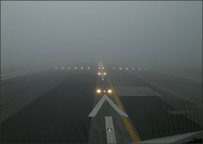
Terrain And Time Of Day
The A-in-the-triangle symbol only relates to using the procedure to file an alternate airport. But there are many other ways and reasons a procedure may not be authorized. It does not apply and may not appear at all when several other limitations apply to the approach…which takes us back to the need to read the notes. Time of day often has something to do with whether or not the approach is authorized.
“Occasionally, operations at an airport may be limited at night,” writes James E. Terpstra, Senior Corporate Vice President at Jeppesen: “Because runway lighting is required for approval of night instrument operations, some approaches are authorized only during the day. In some cases, the mountainous terrain around an airport is so significant, some night operations may be limited or not authorized at night.”
It also may be that obstacles or terrain permit circling in daylight conditions—even in poor weather that requires a circle-to-land maneuver—but the obstruction is not lighted, so attempting the circle maneuver at night is hazardous. In this case, a note such as “Circling to Rwy 5-23 NA at night” provides the warning.
A variation on nighttime approach restrictions is prohibiting straight-in minimums. At first glance this may seem a bit odd. It sounds like it means straight-in procedures are not authorized, but circling maneuvers are. That seems backwards. What the “Straight-in minimums NA at night” notation is really saying, however, is that you must use the circling minimum value to define MDA, DH or DA, even if you’re flying a straight-in approach. In other words, a straight-in procedure is authorized, but you must use the higher circling minimums. This is usually because the runway has limited lighting, requiring more conservative criteria.
If high terrain or obstacles exist near the airport, straight-in approaches may be available but circle-to-land procedures may not be. That limitation could mean a mandatory downwind landing. A variation on this theme is when an obstacle exists on one side of the airport but not others, and circling is not authorized if it takes the airplane near that obstacle. In this case, you may see a note that says “Circling NW NA,” for example, if any circling maneuver that would take the airplane northwest of the airport puts it in conflict with the obstacle. Another example would read “Circling to Rwy 15 NA” if maneuvering from the straight-in final approach course for the procedure(s) being flown cannot safely end with a circle-to-land maneuver to Runway 15 (in this example).
Meteorological
Not only can the time of day result in a procedure becoming not authorized, but so can extreme weather. Procedures using GPS to generate an electronic glidepath through baro-VNAV may not provide obstacle clearance below the procedure’s minimum descent altitude (MDA). So…what the heck is baro-VNAV?
It’s an RNAV (GPS) system employing barometric altitude information from the aircraft’s altimeter to compute vertical guidance. The specified vertical path is typically computed between two waypoints, or an angle from a single waypoint. When using baro-VNAV guidance, pilots should check for any temperature limitations possibly resulting in approach restrictions.
Other factors also may apply, and a baro-VNAV procedure may not be authorized due to no local altimeter source being available. This is why IFR approach-certified GPS navigators with VNAV capability prompt the pilot to enter the current altimeter setting into the box before loading an approach. The GPS uses its terrain database to calculate and display an electronic glidepath using barometrically derived altitude information.
The FAA’s Aeronautical Information Manual (AIM) tells us, “A minimum and maximum temperature limitation is published on procedures which authorize baro-VNAV operation. These temperatures represent the airport temperature above or below which baro-VNAV is not authorized to LNAV/VNAV minimums. As an example, the limitation will read: ‘Uncompensated baro-VNAV NA below -8°C (+18°F) or above 47°C (117°F).’ This information will be found in the upper left hand box of the pilot briefing.” It’s important to note at this point that temperature limitations do not apply when using approach-certified WAAS receivers and they’re annunciating that LPV or LNAV/VNAV are available.
The AIM goes on: “When the temperature is above the high temperature or below the low temperature limit, baro-VNAV may be used to provide a stabilized descent to the LNAV MDA; however, extra caution should be used in the visual segment to ensure a vertical correction is not required. If the VGSI [visual glide slope indicator] is aligned with the published glidepath, and the aircraft instruments indicate on glidepath, an above or below glidepath indication on the VGSI may indicate that temperature error is causing deviations to the glidepath. These deviations should be considered if the approach is continued below the MDA.”
In other words, if you’re flying a GPS approach using a non-WAAS approach-certified GPS, watch for limitations on the use of the advisory glidepath in very hot or very cold conditions. If you’re using a WAAS GPS and/or the temperatures are not extreme, you’ll quickly dismiss this warning when you see it. That said, you may find your airplane is equipped to apply baro-VNAV temperature compensation. The problem is such systems only correct for cold temperature—a high temperature limitation may still result in your planned approach being not authorized. Regardless, such a system may require activation by maintenance personnel during installation in order to be functional, and some systems may apply temperature-based altimeter corrections all the time. If you think your aircraft’s systems automagically compensate for temperature extremes and you need not adhere to “not authorized” notes, it might be a good idea to verify your understanding with the manufacturer’s and installer’s paperwork in hand prior to disregarding the temperature limitations. This is not an all-inclusive list of the procedures that may not be authorized for a given approach. Read the notes completely as you brief for the approach. Remember, your success is in the details.
It’s Not ATC’s Job
One last citation from the AIM: The FAA directly advises pilots of our responsibility to adhere to these notations in Section 5, where pilot and controller roles and responsibilities are described. When considering instrument approaches, the AIM states the pilot’s role is to follow “the procedure as shown on the IAP, including all restrictive notations.” These can include a host of “not authorized” notations, plus whether radar is required or any other limitation appropriate for the procedure.
An air traffic controller’s basic job is to separate airplanes from other airplanes. If they have time, they do other things, like suggest headings or ask other flights about turbulence. They are not responsible for protecting pilots from themselves. It’s your responsibility to research and adhere to any restrictions on approaches and landings. It’s all part of the awesome pilot-in-command responsibility you accept when you exercise the amazing freedom of flight.


