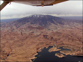
Sugarloaf Mountain is a popular visual checkpoint for pilots here in central Maryland where Im based, but with its peak rising just 800 feet above mostly flat farmland it barely qualifies as a mountain. After a recent tour of the Southwest in my flying clubs Cessna 182RG, I have a new appreciation for really big mountains, density altitude and the tricks they can play with our little airplanes. Also from that trip comes a tale of how a group of flatland pilots from the East 288 coast did the planning, the navigation, the weather-checking and the aviating over unfamiliar territory and lived to do it again. Its also a primer on how even low-time pilots flying basic, non-turbocharged airplanes can, with a little planning and lots of flexibility, tackle these and other challenges without becoming a statistic. In The Beginning… Jens, Dave and I prepared for the trip for weeks, searching for interesting things to see and do along the 1700 miles between Phoenix Sky Harbor International (PHX) and our home base at Montgomery County Airpark (GAI) in Gaithersburg, Md. A second team of three had flown the Skylane to PHX the week before. Both teams practiced simulated high-elevation takeoffs at home and concluded that with partial power and flaps applied, the airplane would lift off within 3000 feet. We practiced steep canyon turns and completed AOPAs online mountain flying course, but whether any of this research and experimentation would help us conquer the Southwest remained to be seen. My team departed PHX on Friday, April 20 and headed north for a scenic tour of the Grand Canyon. With light winds, a temperature of 23 degrees C and a field elevation of 1135 feet, we anticipated our 235-hp bird at maximum gross weight would need about 1500 feet of runway to get airborne, with a 50-percent “fudge factor” over book value included. Jens chose zero flaps for takeoff to maximize acceleration, since we had 10,500 feet of runway and no obstacles to clear-but at least not right away. After rolling about 1800 feet, the airspeed was sufficient and he gingerly raised the nose. We lingered in ground effect for a few seconds before reaching Vy-quite different from the perky takeoffs and 1000-fpm climbs we routinely experience at sea level, at lower gross weight. At the higher elevation airports we visited, our non-turbocharged Skylane RG produced 22-23 inches of manifold pressure on takeoff when leaned for best power-better than expected. It was interesting to observe the plane producing only 17 inches of manifold pressure with full throttle in cruise at 11,500 feet-by the book, but a bit disconcerting to this group of reach-the-beach pilots. We experienced some roughness due to carburetor icing on several legs, including the flight from Phoenix to the Grand Canyon, which took us over some very high and rough terrain with few attractive emergency landing sites. We had not expected this in such a dry climate, but flew with the carburetor heat on as a precaution. This affected our climb performance but kept the engine humming. From then on, we followed roads wherever practical. Watching Weather Our goal was to spend Friday night in Sedona, Ariz., but with forecast gusts to 35 knots, we opted for Winslow instead. Just five days earlier, a Beech Debonair crashed on approach to Sedona, killing the Commercial pilot and his two passengers. According to the preliminary NTSB report, winds were gusting up to 45 knots. Sedonas 5129-foot Runway 21 sits on a plateau at 4830 feet. Winslow, on the other hand, is surrounded by flat terrain and has a much longer runway (7499 feet) even though it is at roughly the same elevation. It seemed like the better choice. We planned to take a northerly detour on Saturday to land at Lake County Airport (LXV) in Leadville, Colo. At 9927 feet, it is the highest-elevation public airport in the country, and the place where many airframe manufacturers conduct hot-and-high testing while seeking FAA certification. This would be a real test of our aviation abilities, involving flying near our airplanes service ceiling and between mountain peaks that topped 14,000 feet. We did our homework and believed the mission would be safe if we took off with minimum but adequate fuel to keep our weight low, had severe-clear weather, avoided narrow mountain passes and followed the river valley. But the less-than-enthusiastic takeoff from Phoenix due to our weight, combined with the carburetor ice encounters, left us with serious doubts about attempting Leadville even under ideal conditions. We decided to remove it from our itinerary. It was Daves turn to fly as we departed the Grand Canyon Airport (GCN) to the southwest with winds right down the runway at about 20 knots. The ground run was short, though the plane struggled to climb at 300 feet per minute even after the flaps and gear were retracted. The surrounding terrain is relatively flat with few obstacles south of the airport, which made the paltry climb rate less worrisome. Dave inched us up to 7500 feet for the one-hour flight to Winslow, where I fully expected us to be standing on a street corner later that evening, with cold beers in hand, singing an old song by Glenn Frey and Jackson Browne. We werent airborne long before we noticed virga on both sides of our course, at about our altitude. The Nexrad picture on our hand-held Garmin 396 confirmed what we saw outside. Visibility was excellent below the clouds and we could see clearly toward Prescott to the south, so we pointed the nose that way. The last thing we wanted to do was to fly on instruments near those mountains. Sedona Seduces On a whim, we checked the AWOS at Sedona and, to our surprise, found it was reporting light southwesterly winds and clear skies. We updated the GPS to paint a line to Sedona, and visually confirmed that the path was precipitation-free. The decision was unanimous-we would spend the night in Sedona and, with any luck, enjoy a stunning sunrise against its red rock cliffs. Saturday morning broke instead with low clouds and rain showers, with the forecast calling for continued marginal conditions. The night before we had discussed flying over Utahs Monument Valley on Saturday and spending the night 288 in Santa Fe, N.M. However, with such a late start from Sedona due to poor weather, the best we could do was some local sightseeing followed by a short flight to Winslow, which put us in better position to reach Monument Valley and Santa Fe on Sunday. Differences The pre-flight at Sedona brought something odd to my attention. The manifold pressure gauge indicates induction air pressure in inches of mercury, so with the engine not running, it should read equal to the pressure at the surface. If it isnt, then the system may have a blockage somewhere. Back home in Maryland, during each pre-flight inspection I check to see that the manifold pressure agrees with the current altimeter setting. This works fine when you are near sea level, but at the higher elevation airports we visited, the actual pressure at the surface was one inch lower for every 1000 feet above sea level where we happened to be. It took me a few minutes at Sedona to realize that this was correct, because it looked so weird to see the manifold pressure gauge read 25 inches when the local altimeter was 30 inches. The five-inch difference represented our field elevation of nearly 5000 feet. The next day we flew over Monument Valley as we made our way toward Santa Fe, with a stop for lunch in Aztec, N.M. (N19). On the approach to Aztec, we looked to our left and saw the snow-capped Rocky Mountains in the distance, and wondered briefly what it might have been like to fly them and land at Leadville. But in the end, we were happy to have left the real mountain flying to the pros. Although we didnt make this trip in the hottest part of the summer, a group of East coast pilots got a taste of what its like to deal with high and hot conditions, along with unusual-for us-topography. What resulted was an education about the need to review our planning, consider the airplanes performance relative to the terrain and be willing to change our plans. The same applies to you. Meredith Saini is a freelance aviation writer and flight instructor flying from the Gaithersburg, Md., area.