
We have a love-hate relationship with cockpit gadgets. On one hand, were strongly in favor of anything that simplifies aviating, navigating and communicating. On the other hand, weve too often seen people get caught up trying to make the gadget work while ignoring the airplane. In the end, we (and our wallets) always have yearned for some kind of inexpensive all-in-one magic box to simplify cockpit chores. Garmins latest GPS portable, the GPSMAP 696, comes about as close as weve seen.
Its not perfect, its definitely not cheap and it occupies a lot of space in what
288
might be cramped quarters, but the sheer volume of features and the ease with which they can be accessed pretty much demand anyone shopping for a portable GPS navigator take a close look at the 696. Moreover, having one of these in the cockpit might save what otherwise could be a very bad day. Lets look at what those safety features are and how they work.
Virtual Panel
Garmin portables since the monochrome 196 have featured a virtual instrument panel. Using GPS to sense rate of turn and vertical velocity, this pseudo panel provides a backup in the case of panel-mounted gyro failure and is surprisingly sensitive and accurate. Those who have used it as their sole means of controlling an aircraft-whether for practice or in extremis-uniformly report it works as advertised.
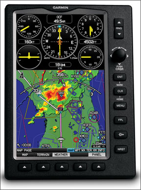
But one of the consistent problems with the virtual panel, no matter the Garmin portable in use, has been its exclusivity: If/when you really needed it, there was no easy way to access the units other features, like its moving map or weather information, while viewing the instruments. That either/or problem was really an issue related to screen size and, with the 696, is no longer a problem.
As the Garmin-supplied image on this page demonstrates, the 696 has enough real estate to easily display the virtual panel along with the moving map, real-time Nexrad weather and your navigation situation. All you have to do is aviate and navigate. Yes, its a temporary solution and, no, we wouldnt want to fly any further than the nearest suitable airport using the virtual panel. But its there if you need it, along with a host of other information you couldnt display previously.
Safer Taxiing
Most of the time, finding your way from the ramp to the runway isnt a problem. Even if youre at a large, towered facility, you can ask for progressive instructions. But at large, non-towered airports, during poor visibility or late at night when the tower is closed, a little extra help comes in handy. Enter the Garmin 696s SafeTaxi feature.
Using FAA-standard taxiway and runway diagrams and overlaying them with GPS isnt new. In fact, SafeTaxi, which first became available on Garmins smaller-screen 496, does exactly what youd expect: depict the aircrafts position on the airport. But SafeTaxi goes one better by also highlighting high-risk areas like complicated taxiway/runway intersections and chronically crowded spots where, for example, wingtip clearance can be an issue.
The 696s much-larger display, however, overcomes any limitations SafeTaxi experienced on the 496, helping to minimize or eliminate the need to zoom in and out while using the feature. The top image at right provides an example of SafeTaxi in action on the 696. The red shading denotes areas at high risk for collision.
IFR Charting
The 696 isnt the first portable GPS to include data used in IFR approaches: Built-in Jeppesen databases have been doing this for years in products available from Garmin and others. And, the 696 doesnt mark the first time electronic chart products have been available in the cockpit, whether via a portable or panel-mounted unit.
But the 696 is the first time anybody has seen instrument approach procedure charts available in a dedicated portable GPS. Its also the first time weve seen Victor airways included on the screen as part of a passable imitation of the FAAs own low- and high-altitude en route charts. Naturally, the en route charts can be displayed along with the aircraft position; the approach charts do not include this capability.
As the bottom image at right demonstrates, the en route chart presentation can be overlaid with terrain, as displayed, or with weather data. This greatly simplifies airborne decision making when, for example, youre asking for a deviation around weather and are forced to apply some “Kentucky windage” to figure out where the weather is, where its going to be and where you want to be.
When considering all the paper many of us must carry aloft to ensure we have the proper chart aboard, the other benefit of having all this information in the 696 comes through. As long as the 696 was recently updated-within 180 days for the en route charts and approach plates-we can pull up that data and use it in a pinch. Obviously, if its the most-current data, the 696 then fulfills one of its major design objectives: serving as an electronic flight bag. And, while not necessarily a safety-of-flight item, its important to note the unit also includes the AOPA Airport Directory.
Summing Up
Weve had a 696 to play with for a few weeks and really dont think its an exaggeration to say this is a pretty hot product. In one portable unit, it includes tens of thousands of dollars worth of hardware, software and data formerly available in panel-mounted avionics. It wont automagically give your aircraft powers it doesnt now have-the ability to file /G, for example. But it does bring to the simplest aircraft-even those without electrical systems-most capabilities found in the latest-generation glass cockpits. That alone is a safety feature.
Its trite to point out a collection of features put together in one product results in something greater than its individual parts. But thats what we have in Garmins 696. All you have to do is find a place for it in your cockpit.


