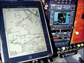
Any instrument-rated pilot should know, as a double-I we knew well would stress, “While youre flying straight and level is a good time to get set up for the approach.” Sage advice, but that was back in the days when pilots of most personal airplanes considered themselves fortunate to have a working DME. Moving maps hadnt been invented and the first GPS satellite had yet to be launched. As long as we had current plates-which was most of the time-and a record of a VOR 288 check having been performed in the preceding 30 days, we were good to shoot almost any approach this side of a CAT IIIa ILS, including the then-feared-but-now-rare NDB procedure. Since then, things have gotten decidedly better, including automation, utility and accuracy. But theyre much more complicated, also. Instead of worrying about where the nearest VOT is, today we need to familiarize ourselves with terms like RAIM, WAAS, LNAV/VNAV and AFMS while checking the expiration of various databases and our electronic approach plates. And we need to do all this before deciding whether we can even shoot the approach, much less which minima applies to our equipment and its status that day. The automation and flexibility available in the average personal airplanes panel today comes with increased responsibility for knowing the revision status of every item in it, and the impact it may have on our ability to use the approach at our destination. Lets explore some of these considerations. Out Of Date? One of the most basic considerations pilots using the approach-approved equipment in their aircraft must contend with is the regular cycle of updates to databases. Every 28 days, a new data set is available and must be installed in the panel-mounted equipment to continue using its full capabilities. These updates, of course, are separate from the need to replace any paper or electronic charts, or information used by terrain-avoidance equipment. For those flying infrequently, it often can come as a rude surprise to start getting set up for an approach only to find the data card is corrupted, a cycle or two behind. Ideally, of course, wed always have the latest information aboard. But, things sometimes do fall through the cracks, and in-flight diversions to an unplanned destination do arise. How to handle these challenges depends on which approach-approved equipment youre flying behind. For comparing a current chart to a suspect database, the sidebar at right details changes both Jeppesen and FAA/AeroNav have made to their formats, enabling operators to more easily determine whether the procedure has been changed since the database was published. To determine what, if any, IFR operations may be conducted using a GPS navigator with an expired database, the first place to start is the units documentation. An FAA-approved aircraft flight manual supplement (AFMS) should have come with the installation and should be part of the aircrafts paperwork complement. In it, operators will find details on whether and how the navigator may be used with an expired data card. Since the AFMS is a regulatory document, what it says governs how operators may legally use their nav equipment. But a close reading of that document is necessary. For example, a recent AFMS for Garmins products contains the following language: “GPS instrument approaches using the 500W Series units are prohibited, unless the 500W Series units approach data is verified by the pilot or crew to be current. Instrument approaches must be accomplished in accordance with an approved instrument approach procedure that is loaded from the 500W Series unit database.” A casual reading of this statement could be interpreted to mean you cant use the unit to shoot a GPS approach if the data has expired. But a closer reading will note the statement details operator verification of the data to be used, not the database itself. Thats because, while the database may be out-of-date, the data in it for the approach you want to use may be the most recent. In this instance, Garmins documentation allows operators to verify the approach data and, if its correct, use it-even if its within an expired database-to shoot the approach. For details on how to verify the approach data, be sure to refer to the sidebar on page 13. Meanwhile, be sure to review the specific documentation that came with your GPS navigator-it may or may not allow data verification in lieu of a current database. What About Alternates? All instrument-rated pilots are-or at least should be-familiar with the need for listing an alternate airport when filing a flight plan: If, during the period one hour before and one hour after our planned arrival, the forecast ceiling is less than 2000 feet or visibility is advertised at less than three miles and were flying something other than a helicopter, we need to file an alternate. A standard alternate weather minima, of course, must include a forecast of at least 600-1 if a precision approach is present, or 800-1 if only non-precision procedures are available. These rules have served us well over the years, but arent the last word when we plan to use GPS at the alternate airport. For example, presume we need to file an alternate airport for a planned flight. Also presume we have a non-WAAS GPS navigator aboard, along with a functioning ILS receiver, but our DME is on the fritz. The ILS procedure at our preferred alternate includes the note “DME REQUIRED.” Can we legally file for that alternate airport? Yes, because GPS is allowed as a substitute for DME. However, the answer would be different if, for example, RAIM integrity is lost or the GPS navigators design prevents us from properly identifying the DME distances required for the ILS procedure. What if the airplane is equipped with a WAAS-certified GPS navigator? Again, the picture changes. According to the FAAs Aeronautical Information Manual (AIM), “Pilots with WAAS receivers may flight plan to use any instrument approach procedure authorized for use with their WAAS avionics as the planned approach at a required alternate.” Of course, restrictions apply. First, any published GPS/RNAV procedures at the alternate airport must not include the “alternate minimums not authorized” symbology. Second, the operator must plan not to use the WAAS receivers vertical guidance, even if its used during the actual approach. Since a WAAS-certified receiver includes its own signal-monitoring, this answer is the same even if RAIM integrity isnt available at the alternate airport (see the sidebar on the opposite page). Finally, of course, the forecast weather must meet the requirements before the airport can be listed as an alternate. Fine Print Theres no question GPS and terminal procedures based on it have vastly improved the safety, utility and efficiency of using personal aircraft. At the same time, many of the practices with which some old-timers have become comfortable have changed, with additional details and considerations. More than ever, pilots must have a thorough understanding of the fine print associated with specific GPS navigators, their installation and the various regulatory complexities. Its almost enough to force us to go back to ILS and DME alone. Almost.