
Against the soothing background clatter of the flight service briefers keyboard, one question youd rather not hear: Do you have weather radar aboard? To use the metaphor of the hour, we dont need to have the dots connected for us. What the question implies is, Youre gonna need it.
Yet very few pilots flying serious IFR have weather radar, especially in singles, where it doesnt work especially well anyway. Even the radar found in light twins is of limited utility due to the narrow beam width of the small-diameter antennas piston twins typically have.
Its nice to have radar, a sferics device or both. If you have neither, you have less to work with in navigating convective weather, but less is not the same as nothing at all.
Flying in convective weather without airborne avoidance equipment is doable if you use all the ground-based aides available – and there are more than ever – provided you accept certain limitations. Its analogous to flying in ice without boots or TKS. It can be done; it just cant always be done.
More Than Ever
Compared to a decade ago, theres more ground-based weather radar available than ever. Specifically, the FAAs ASR-9 terminal radar is now widely available – there are about 135 sites – and the NWSs NEXRAD radar system is fully deployed. While its true that neither of these can be instantaneously viewed from the cockpit, both can still be put to use in making both strategic and tactical decisions on thunderstorm flying.
Moreover, the ground-based National Lightning Detection Network is also available through online services and it can be a valuable tool in go/no-go decisionmaking when thunderstorms are a factor.
Last, consider commercial domestic radar services. The Weather Channels local dissemination of doppler radar data is as credible a source for convective data as anything Flight Watch has. We always consider TWC the first source on any day when thunderstorms are likely to pop.
Combine all this radar with the textual convective outlook, a look at dewpoints along the route and the winds aloft and youll be armed with the data you need to fly in convective conditions – up to point. Even with radar and sferics, you have to draw the line somewhere. When you have neither of those instruments, the line may have to be drawn closer to the hangar door.
Pick Your Days
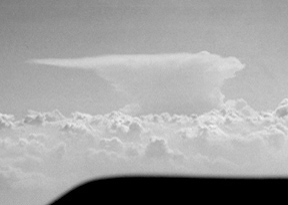
Some thunderstorm conditions are simply unflyable, regardless of the airplane. A vicious and fast-moving cold front squall line with tops in the 50s is not to be trifled with. Monsters like these spew high winds and hail and even the guys flying the best airborne radar in the business will wait them out. Why expend the adrenaline circumnavigating when the show will move through in under an hour?
But what about the hot, hazy day when general thunderstorms are forecast, either isolated or in lines? Or a weak cold front with perforated lines and clusters? These are childs play to avoid with radar or sferics and very often, they can easily be circumnavigated with neither of those aboard.
Before considering the tactical situation, review the strategic. What kind of system will make the weather? Is it a cold front? A low pressure kicking off energy pulses? Or just local convection on a humid day? Each may require a different strategy.
When briefing up on a convective day, you cant have too much information. Look at the prog charts for position of fronts and pressure systems, current radar, satellite/radar combined, if available, and the convective outlook from the NWSs Storm Prediction Center (www.spc.noaa.gov/products) in which the forecasters will explain the thunderstorm mechanisms for the day.
Heres an example of convective outlook analysis: Central/Southern Plains: Active severe weather day is unfolding across portions of the Central and Southern Plains. Thunderstorms have already developed across parts of the area ahead of a weak shortwave trough moving southeastward. As this feature continues to evolve … a surface system is expected to develop across portions of eastern Colorado or perhaps far western Kansas.
If the outlook calls for widespread severe activity, it may be a better idea to cut your losses early and reschedule the trip. Cancellation is an art and it needs to be practiced occasionally.
Even if you dont fly that high, have a look at the winds aloft at the 500 MB level or about 18,000 feet. These are the steering winds for thunderstorms and when they are uniformly brisk during the summer – greater than 30 knots – with lots of moisture present, the likelihood of severe storms is higher.
Last, look at the dewpoints enroute. Dewpoints in the 40-degree range probably wont ignite much serious convection but 70-degree dewpoints indicate a sopping wet atmosphere that may explode with late-day heating or the lifting action of a fast-moving cold front.
Speaking of which, if theres no frontal activity to kick off the convection – the convective outlook will tell you that – then you may be able to fly your trip early in the day and entirely avoid the isolated convection caused by local heating.
If a front is doing the dirty work, it can launch convection at any time of day and the higher the dewpoints along the fronts path, the worse the storms will be.
But the good thing about frontal weather is that the position of the front is known, so youll have some idea of where and when to expect the storms, which tend to move rapidly in long, narrow lines. (As we write this, a spectacular squall line stretching from Michigan to the Gulf of Mexico is getting attention on The Weather Channel. Although the squall lines along that front are impressively continuous, none are much more than 10 miles wide.) There may be gaps in weather like that wide enough to fly through visually, but even if there arent, the front will move fast enough to allow waiting it out.
If you expect to encounter frontal convective activity, one strategy is to fly toward it head-on and land somewhere just ahead of it. Take along lunch and a good book and chances are youll be on your way behind the front in under an hour. Strategically, if possible, pick a bolt-hole airport likely to have Internet access or a weather terminal so you can keep track of the mess as it passes.
VFR not IFR
Having ATC provide separation and traffic services under IFR is may be a good thing, but it comes at a price. Youll have to follow ATCs preferred routes and youll be hemmed in at times by both routing and altitude.
This isnt a good deal if you have weather avoidance gear aboard and its even worse if youre without radar or sferics equipment.
When avoiding thunderstorms without benefit of airborne radar, youll have to depend entirely on your eyeballs – and they dont work very well if youre in cloud. On the other hand, when IFR, you can more easily take advantage of ATC radar for weather avoidance. More on that in a moment.
Although controllers are cooperative about weather deviations, theres always the chance youll be intimidated into going where you would rather not just so ATC can keep the metal separated. Further, under IFR, you cant climb and descend at will, which is a must when avoiding storms visually. Obviously, you can still obtain ATC weather help when operating VFR with radar advisories, and that strikes us as the best of all worlds.
When flying in convective conditions and deviating visually, the higher the better. In humid summer weather, dense haze will keep you from seeing cells until youre on top of them. This will require large deviations and perhaps even 180-degree turns.
Summer haze layers often top out in the 6000- to 10,000-foot range so climbing above the haze is recommended and thats doable in even normally aspirated single-engine aircraft.
Cruising on top with unlimited visibility, you can see convective weather for dozens of miles and you can execute small deviations to avoid it. An impenetrable line will be obvious from higher altitudes and you can plan accordingly.
Ground Help
With no tactical avoidance equipment to rely on, youll have to supplement your eyeballs with ground-based weather radar. This varies from the practically useless Flight Watch radar to the very good, ATCs ASR-9 terminal radar.
We say FSS/Flight Watch radar is useless because although these radar feeds are real time, its difficult for the briefer to convey an accurate picture of what he sees relative to where you are. And when trying to pick your way around cells, weather position is everything. And theres always the nuance of trying to find a gap in a line that really is a gap, not just a sucker hole.
It helps if you not only know your exact position but you can describe it to the briefer. Instead of were 20 miles southeast of Fort Wayne try were 20 miles southeast of Fort Wayne, northwest bound on Victor 277, northeast of OSBER intersection. Where is the weather area relative to the airway?
FSS briefers dont know the airspace as well as controllers do but they know where VORs and airways are. The more accurately you can describe your position, the more accurately you can picture the weather around you. A briefer whos good with the equipment can suggest a general direction to fly for gross weather avoidance, which is the best kind to practice when youre sans airborne radar.
In active convective weather, youre likely to encounter a congested Flight Watch frequency, which may make it impossible to obtain timely reports. You can help everyone else and yourself by merely monitoring the Flight Watch frequency on the standby comm well before you have questions about the weather.
If youre worried about thunderstorms, other pilots will be sweating it, too, and the general descriptions given by the Flight Watch radar briefer will apply to everyone. You can get valuable information without making a single transmission.
Flight Watch briefers describe weather and watch boxes bounded by VOR locations so a chart large enough to show stations over a large area will help you visualize the weather. (Jeppesen publishes a small U.S. map that shows only VOR locations. Copy it and sketch the boxes right on the chart.)
ATC Assistance
By now, the myth that ATC radar cant see weather has been thoroughly dispelled. But it remains true that some ATC radar is better at weather detection than others. Besides, regardless of the system, its efficacy depends largely on the controller using it.
Center radar – ARSR-3 and -4 systems – have long range and are with equipped with rudimentary weather processing capability. If the weather processor is engaged and displayed on Center radar, the controller sees level 1 rain as an area of slashes on his display while level 2 and higher is depicted as Hs.
The limitations of this display are obvious. The Hs could hide anything up to level 6 so the obvious strategy should be to avoid the Hs. You can ask the controller for vectors or general advice on where the heavier rain is. Although Center radar will detect heavier rain, that doesnt mean its convective. Nonetheless, heavy rain is hard on paint and props, so why not avoid it?
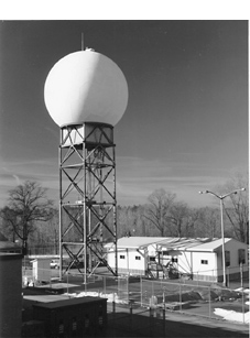
For the better part of the last decade, the FAA has been fielding ASR-9 terminal radar, which has weather processing capable of detecting the standard 6 VIP rainfall levels normally used to describe weather intensity.
In recent years, weve noted that in facilities equipped with ASR-9, some controllers have become highly skilled at using it, to the point that theyll happily provide close-in multiple vectors around weather areas.
Again, this is operator dependent. ASR-9 can be configured to display or suppress all six VIP levels and you shouldnt assume that the controllers idea of hazardous weather agrees with your own. Pick a level youd like to avoid – level 3 and above is a good start – and advise the controller accordingly. While youre at it, unless youre certain about it, confirm that ASR-9 is actually in use. Its not the sort of thing that should go without saying. Some controllers may offer weather advice based on ASR-7 returns, but that system is hardly the equal of ASR-9.
One last ground-based resource thats often overlooked: AWOS/ASOS. Review your charts and youll find lots of these weather robots in service around the country. Some have lightning sensors but thats not necessarily the most valuable information AWOS/ASOS can deliver. If youre trying to pin down distant storm location, the arrival of a gust front may reveal itself as a windshift/increase at the automated station. Some are also equipped with rain detectors. ATC sometimes has real-time access to AWOS/ASOS data, if you cant receive it due to distance from the station.
When It Looks Bad
In reviewing NTSB reports, it appears that many thunderstorm-related accidents occur because pilots venture too close to cells they can see on radar or sferics devices or they blunder into weather they cant see because they arent equipped.
The simple truth is that if a weather area looks dark and foreboding visually, it probably is. Dont go there. If it looks marginal, absent any good real-time information to the contrary, dont go there.
Similarly, if the forecast calls for embedded thunderstorms and you cant reliably get on top of or between any layers to avoid them visually, it may be a good day to exercise your always-available cancellation option. Theres nothing wrong with having a look on such days, but if the view is obscured by clouds that cant be penetrated by ground or airborne radar it may be time to call it a day early.
Also With This Article
Click here to view “Datalink Weather: Strategic, Not Tactical.”
Click here to view “Tricks and Traps.”
-by Paul Bertorelli
Paul Bertorelli is an ATP, CFI and editor of Aviation Consumer magazine.


