
If the lure of exploration is strong, those magazine pictures of the backcountry airstrips, such as those in the Northern Rockies, are an irresistible lure. Vast areas in the United States are designated as wilderness area and are accessible only by horseback, hiking, drift boat – or airplanes.
Most wilderness areas contain a system of airstrips ranging from nice grass airstrips with plenty of width and length to strips that are barely wide enough for the landing gear of a STOL aircraft. This is a very challenging aviation environment that must be flown by the right pilot, with the right equipment, training, experience and weather.
The safety margins are very thin in these operations, and this is not the kind of flying where a self-taught course is sufficient. A small oversight in any of these can easily result in bent metal hundreds of miles from any kind of rescue or other support.
Mountain Air
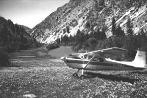
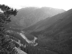
Backcountry terrain is often dominated by mountains and their associated canyons and river bottoms. In the Northern Rockies, the various tributaries of the Salmon, Clearwater and Selway rivers cut through the canyons. Thick timber or rocks cover most of the terrain, and much of it is steep. You will find precious few meadows for safe emergency landing spots.
If an engine fails over this terrain, you will be faced with the choice of a cliff or a whitewater rapid for a landing spot. In 1979, a DC-3 carrying firefighters experienced an engine failure in this rugged country and was unable to climb to better terrain.
The pilots were forced to ditch the aircraft in a fast-moving river, whereupon many of the firefighters were killed, either by impact or drowning. When I was flying firefighters in this country in the relative comfort of a twin-engine turboprop, my way out in the event of an engine failure was literally to fly downriver for a hundred miles or more until the river emerged from the wilderness area into flatter terrain. There are few good escape routes in this country.
The terrain also has a huge impact on the winds. As the steep hillsides cool in the evenings, they produce down-canyon flows that then cool off the river bottoms. It isnt uncommon for the temperatures to dip far enough at night that youll need a campfire to remain warm.
Frost can form on many mornings, even in the middle of summer. The wide range in daytime and night temperatures is common throughout the Mountain West because of the very dry air. During the afternoons, temperatures can readily soar to triple digits in the canyon bottoms, and the south-facing slopes heat rapdily, creating strong thermals that cause very bumpy flights and make aircraft control tricky when trying to land at confined airstrips.
The terrain can do some other tricky things to the air. The air from cool hillsides and snowfields tends to move downhill and collect in the drainages, then proceed downriver. When that cold air rushes into other air masses at an intersection of two canyons, there can be a considerable wind shear – often just a hundred feet off of the ground. This becomes particularly tricky while trying to land or take off.
The windsock on the airstrip may show the winds to be from a certain direction and velocity, but the winds just 100 feet higher can be doing something dramatically different. Mountain airflows are anything but simple, particularly in complex rugged terrain. Ridge flows, updrafts, downdrafts, steep wind gradients and mountain waves are very common in this country and must be flown with caution.
The terrain also funnels the winds. As the wind flows through narrower sections of the canyon, a venturi is created and the air speeds up. As the wind flows around a curve, the air on the outside of the curve flows faster, much as it does around a wing. The faster air has less pressure, so a secondary airflow is established in the wind, flowing from the slower air to the faster air near the outside of the curve.
Air flow is also affected by the downdrafts from thunderstorms that may be miles away. The air proceeds down the drainage, unknown to you as you prepare for takeoff from an airstrip buried deep in a canyon. You have no way of knowing the flow is there, but its effects are very real and impossible to predict.
During the summer months, when most people opt to fly in the backcountry, high temperatures also mean density altitudes can be quite high. This country is particularly unforgiving of high density altitude – a point that is lost on some pilots until they hear the stall horn blaring away as the wheels skim just feet above the treetops.
Since most of the airstrips are rather short, takeoff performance seems excruciatingly poor when compared with the trees, cliffs and rivers at the end of the runway. Takeoff distances are lengthened and climb rates are reduced to meager rates.
The distance from the river bottoms to mid-canyon altitudes can easily exceed 3,000 feet, and anemic climb rates mean it can take a half hour to reach a cruising altitude. During the climb, youll be threading through the confines of the canyon walls.
There are two ways to stack the odds in your favor when the temperatures start climbing. First, fly during the cooler portions of the day. In canyon country, that means the mornings. Second, shed some weight from your aircraft. Cutting 200 pounds from your load can do wonders to the climb gradient.
If you have to carry a heavy load out of these airstrips, it is definitely a wise strategy to split your loads and carry a portion of the load to an intermediate location with a larger airstrip and better surrounding terrain, then return for the remainder of the load. Complicating that strategy, however, is the need to tanker fuel when flying to airstrips where there are no services available.
Just as warm days cause their share of complications, the evening temperatures can quickly dive as the sun sets. In early morning, frost is common. You might need to wait for the sun to melt the frost off your wings and dry the runway before an early morning departure.
Runway Conditions
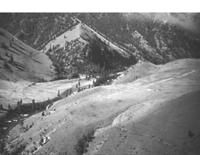
The approaches into many backcountry airstrips are challenging, to say the least. Some of the airstrips are not visible until short final because of the twists and turns of the canyon walls – and thats if youve even picked the correct canyon.
The concept of a stabilized approach is vital in this terrain, but it takes on a rather different meaning. You wont be able to fly a normal downwind to examine the condition of the surface and look at the wind sock. There is no VASI or PAPI to aid your perception of the glide path angle. In the flatlands you have a distinct horizon to help you ascertain the position of the aircrafts nose. Not in the backcountry. All of the terrain is slanted and creates visual illusions. This will complicate not only glidepath control, but also aircraft control.
Pilots are accustomed to having the option to go around if the approach doesnt look right, but in this region, many of the airports are located so deep within steep terrain that go-arounds are not possible under normal circumstances. You may find yourself unable to outclimb the adjacent terrain at many backcountry airstrips when attempting a go-around.
Terrain or wind often dictates landing one way on the runway and taking off in the opposite direction. Many of the runways have significant slopes. These airstrips are not kind to pilot mistakes, and hence it is imperative that you know which runways have one-way operations and which do not allow a go-around.
Many of the airstrips have enough upslope to require an uphill landing. During the morning hours when the prevailing winds tend to move downslope, this is a good combination. However, there is a danger in the visual illusions created by an upsloping runway, which can cause the pilot to drag in the approach. If your airspeed is normal for the approach but you seem to have a higher-than-normal power and a slower descent rate, you may be dragging in the approach.
The airstrips in this region range from a few very nicely groomed grass airstrips to bare soil that is eroded by rainfalls. Some of the backcountry airstrips have developed hard bare spots in the middle of the once-lush grass from heavy use and indifferent maintenance. When landing or taking off in these situations, you may find a rock-hard surface down part of the runway and soft ground or deep grass in adjoining portions.
This makes aircraft control very difficult during takeoff and landing. A classic scenario for an aircraft accident in the backcountry involves pilots losing control during the ground roll under these circumstances. Animal damage, sloping runways, curving runways, trees and obstacles are also very common on these airstrips.
Isolation
Remote terrain is a priceless gift to fishing, hiking and hunting enthusiasts. However, its impossible to stay up to date on weather or wildfire activity. Since most of the airstrips are buried deep in canyons, you wont detect the incoming weather until it is right on top of you.
Backcountry pilots commonly use 122.9 to announce their position and exchange information. Its a vital communication link in the remote terrain, but its only available when other aircraft are in the area. The pilots announce their position using local landmarks, which will likely be unfamiliar to you.
Very few of the backcountry airstrips have any communications with the outside world. You wont be able to check the weather nor inform the outside world about the need for medical help, supplies, or aircraft repair back there unless youre carrying a satellite phone.
If your aircraft develops a noise you dont like, you arent able to stride over to the local mechanics hangar and ask him to take a look. If you need a quart of oil, you cant simply ask the lineman to bring you one. Or suppose you accidentally forget to turn off the master switch and the battery runs down? This isnt the place for an unreliable aircraft and a mechanical malfunction.
Navigation can also be tricky in the backcountry. Often there are no VOR or NDB signals available. Pilotage is the time-honored form of navigation in this country.
GPS receivers help, but arent the panacea you might think. Because of the terrain, you cant just select your destination and fly direct. Winding through canyons and navigating into the smaller drainages can get tricky.
Often you wont believe the GPS when it informs you youve arrived at your intended airstrip. Some of them are little more than a terrace on a steep hillside with a narrow patch of sagebrush removed.
Skills, Information, Equipment
Before you proceed into the backcountry, you must be prepared with the right skills and knowledge. This type of flying requires a pilot with the right skills, the right information, good judgment, and the proper equipment.
The right type of aircraft is essential in this country. The backcountry outfitters fly a combination of Cessna 206s and Islanders for the average airstrip, and use Cessna 185s and Super Cubs for those eye-popping, jaw-dropping airstrips.
Proper clearance of the propeller is a necessity back there, so the Mooney wouldnt be appropriate. Because of the rough terrain, taildraggers are a natural choice. STOL capabilities are a necessity at some of the airstrips. A sufficient power-to-weight ratio is a necessity because of the density altitudes and wind shears. The landing gear should be stout for this kind of country.
This country is terribly unforgiving of pilots who dont have superb stick-and-rudder skills. You may need to make large control inputs close to the ground, and that means you need precise control of the aircrafts speed, glidepath, bank angle and sink rate. You also need to maintain control of the aircraft and reacquire the appropriate landing speed when encountering strong wind shears and turbulence. If your skills arent up to this match, stay home.
Several guidebooks describe the runway slope, special conditions that might exist on the runway, the prevailing weather conditions at the airport, the special hazards for the approach, approach aids for the runway, and camping facilities.
The authors of these books warn that these are not how to books but rather should be used as decision-making aids. They provide information about the hazards known at the time of printing, but backcountry strips are subject to all sorts of transient conditions. Rainfall or animals can damage a grass strip literally overnight. Monitoring 122.9 and asking other pilots about the condition of your proposed landing area is about the only method for obtaining recent information, but even that may be out of date.
Stop at some of the gateways to the backcountry, too. They not only provide specialized instruction into backcountry flying, but you can ask the charter operators for information on the latest conditions.
It is prudent to build your backcountry experience the same way you build any part of a flying repertoire. Begin with less-hazardous airstrips and learn the real challenges of flying into the wilderness in small increments.
Also With This Article
Click here to view “Tales from the Backcountry.”
Click here to view “Backcountry Checklist.”
-by Pat Veillette
Pat Veillette is an aviation safety researcher and air carrier pilot who harbors a love for the backcountry.


