
Thunderstorm. That word causes more angst among aviators than just about any other atmospheric phenomenon. The thought of getting tangled up in the violent bowels of a mature thunderstorm – heavy rain, severe turbulence, hail and lightning – weighs heavily on the mind of any pilot flying or planning to fly when thunderstorms are active.
And that angst is well founded. Every year a number of aircraft, their pilots and passengers are lost to thunderstorms.
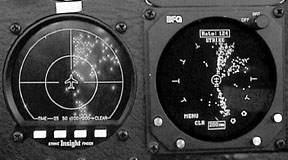
A vast array of ground-based and airborne technology, probably worth billions of dollars, is dedicated to helping pilots identify and avoid thunderstorms. The past 20 years has brought a wide acceptance of cockpit-based lightning detection technology. I recently had the opportunity to use two popular cockpit lightning detection systems, the Insight Strike Finder and Goodrich Avionics Systems WX-950 Stormscope, side-by-side during thunderstorm season.
Cockpit lightning detectors do, in fact, work pretty well, and many pilots make effective use of them to safely avoid thunderstorms. But. They cant do everything, and they are far from perfect in detecting precisely where the storms are and providing a route around or through them.
On-board lightning detection is one leg of a comprehensive strategy that can keep you clear of the storms. Rely on it as your sole source of information, and you may find yourself in trouble.
To create a good platform for thunderstorm avoidance, get a good thunderstorm weather brief before departure, keep it updated once in flight, and recognize the limitations of cockpit-based lightning detection. Before getting into serious thunderstorm situations, develop a grasp of the operational characteristics of the lightning detection device as installed in your particular aircraft.
A pilot contemplating using a Stormscope or Strike Finder to fly around convective weather should also evaluate whether his flying skills are up to the task. Even if youre not actually inside a thunderstorm, the territory around convective weather can be a rather unpleasant flying environment, and the pilot should be able to deal with flying in heavy rain and sometimes spirited, but non-convective, turbulence.
Being able to multi-task is another requirement. Its not enough just to keep the airplane upright and on course in these situations. The pilot must also be able to study and interpret the display of the lightning detector while dealing with all other flying tasks.
How They Work
Stormscope and Strike Finder, sometimes called sferics – short for atmospherics – detect the low-frequency radio energy created by thunderstorms. Theyre receive-only devices and dont use any type of transmitter as a weather radar does.
The huge cumulous cloud that is a thunderstorm contains opposing vertical air currents that create violent turbulence and are the engine that develops the precipitation and destructive hail of a thunderstorm. Find a way to detect these opposing air currents and you can avoid a thunderstorm.
Radar detects the precipitation generated by the air currents. Sferics detect the electrical discharges that result from the positive and negative charges within the cumulous cloud. These discharges occur to bring equilibrium and they radiate electromagnetic energy in all directions. Some of these discharges are visible lightning, but the majority are not.
The vertically oriented electromagnetic discharges are what Stormscope and Strike Finder detect.
They receive this energy through antennas that operate like the combined sense and loop antennas of a modern ADF receiver. The azimuth direction to the detected energy is calculated in much the same way as an ADF finds the way to a non-directional beacon.
ADFs will also point to strong electromagnetic discharges, which leads the pilots of some marginally equipped airplanes to use them as a poor-mans sferic. The real magic of modern sferics is in how they determine the distance to the discharge.
In very broad terms, stored in the electronic brain of a Stormscope and Strike Finder is the electrical signature of a generic thunderstorm discharge. When a live thunderstorm discharge is detected, it is compared to the signature of the one stored in memory. From that basis ranging algorithms are applied, a distance is calculated and a plot is made on the sferics display.
The comparison of the detected strike to a generic one is an obvious source of error. Most pilots are familiar with the super-accurate ground-based lightning plots produced by Global Atmospherics that are shown on The Weather Channel and used by lightning-sensitive industries such as power companies and golf courses. How can those plots be so accurate when cockpit based depictions of the same phenomenon are so famously inexact?
The secret is in the number of sensors. Global Atmospherics has a network of many lightning detectors spread out all over the United States, and each lightning strike is detected by more than one sensor. Since the electromagnetic energy of a lightning strike travels at a known speed, Global Atmospherics is able to calculate the location of the strike through complex geometry and trigonometry from data received from the sensors. Airborne, with only one on-board sensor, the answer is far less precise.
Before You Go
Surprises are something avoided by most good airmen and surprise by thunderstorm is especially nasty. If ever there was a time to get a good weather brief, flying when thunderstorms are active is it. Find out where thunderstorms are now, which way theyre moving and where theyre forecast to develop.
The myriad of tools available today to get a good handle on thunderstorms was just a fantasy when I started flying in the late 1970s. During a flight in January 1982, I went through a shaft of extremely heavy rain and hail in my old Mooney. The encounter lasted less than a minute, but it broke my landing light, smashed flat all the fins on my oil cooler, ripped to shreds a wire mesh air filter, and stripped clean the paint from the leading edges of my wings and empennage.
The deluge of water caused the engine to quit (carb heat, an alternate air source, brought it right back) and every interior crack and crevice of the airplane exposed to the outside had a mist of water coming through it.
That little feat of using my exceptional skill to make up for my exceptionally bad judgment was precipitated by a stale weather brief, which contained not a hint of thunderstorms, and impatience to get airborne. It was shortly after the PATCO strike had decimated the ranks of Flight Service (many FSS folks went off to be controllers). I simply could not get through to FSS on the telephone. Todays wonderful backups to FSS of the Weather Channel, DTN/WSI, internet weather and DUATS just did not exist.
My bad judgment was that I rationalized away a single weak flash of lightning in the gathering dusk while I was taxiing out for departure from the tiny rural airfield for a low IFR departure. Everybody knows that thunderstorms are rare in the winter and especially when the weather is way down. Learn from my mistake and make use of all the terrific graphic-based thunderstorm information available today.
A thunderstorm brief for me begins with a quick look at the weather map big picture of the highs, lows and fronts situation. My next stop is on the internet with a trip to WeatherTAP (www.weathertap.com). There I look at static and time-looped regional composite radar pictures.
Next I view WeatherTAPs lightning plot data to get a first look at what my lightning detector may show once airborne. I finish up by looking at prog charts to get a feel for where thunderstorms are expected to develop later in the day.
Still on the internet, I go over to the page for the NOAAs Aviation Weather Center home page, www.aviationweather.noaa.gov/, and look at text and graphic plots of current convective sigmets along with the convective outlook. Also on the Aviation Weather Center is the National Convective Weather Forecast, which shows where thunderstorms are now and where theyre expected to move in the next hour. The views can be broken down into individual ATC center areas.
At the airport, many FBOs now have DTN or WSI installations that have great weather maps, regional radar displays and text weather.
With all that preliminary work completed I get my official weather brief, usually via DUATS.
The Hardware
The WX-950 Stormscope and Strike Finder are used operationally in much the same way, although each has its own unique characteristics. The biggest difference between the two is their display and the WX-950s capability to switch between two different mapping schemes, the strike mode and the cell mode.
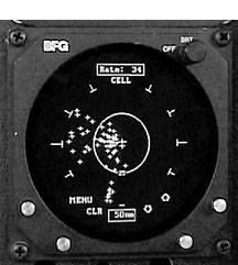
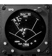
The strike mode operates much like early generation Stormscopes and plots the thunderstorm energy it detects with very little processing. This tends to produce a less compact display of discharges and is very susceptible to radial spread. More about that later.
In the cell mode, the discharges detected go through a high degree of processing that tries to associate the discharges received with other discharges received in the displayed range and view. If a discharge cant be associated, it is rejected for display unless it is within 25 NM of the aircraft. This leads to a more compact display of discharges with greater ranging accuracy and less radial spread.
The WX-950 Stormscope uses a CRT display with the capability to produce a highly precise picture and also has a 120 forward view in addition to the typical 360 view. The 120 view gives an expanded picture with much a more detailed image of the displayed weather and removes from view what I consider to be the WX-950s worst trait – its inaccurate depiction of weather to the sides.
Over the five years Ive used a WX-950, Ive seen time and again how it tends to smear discharges coming from thunderstorms that are at right angles to its antenna. A thunderstorm at a 9 oclock position to the aircraft will display as one big fuzzy area from approximately the 8 oclock to 10 oclock position.
The Strike Finder uses a super-bright LED display. It is equal to the Stormscope display on longer ranges but produces a more coarse view on shorter ranges. The Strike Finder weather depiction is very similar to the WX-950 Stormscope in the strike mode and, like the Stormscope, it is susceptible to radial spread, but to a somewhat lesser degree. Insight calls this phenomenon cell stretch.
Radial Spread and Ranging
Radial spread is the result of the inexact ranging solutions of sferics. This causes discharges to be displayed in spoke-like lines emanating from the center of the display, usually taking a triangular shape that masks the real position of the thunderstorm. The best way to deal with radial spread is to clear the display and note where discharges first appear.
If the thunderstorm electrical signature received is close to the one stored in memory, then the depicted range should be fairly accurate. Those stronger or weaker will display closer or farther away respectively. Your best bet for judging range accuracy is to validate whats displayed through an external source- ATC, FSS, or the old Mark I eyeball.
Using Sferics Safely
Your first choice when faced with flying in thunderstorm weather should be simply plan a route that will avoid them. If your new route takes you miles out of the way, so what? Youd probably add nearly that much deviating around them on a more direct course.
Using sferics for thunderstorm avoidance really is a matter of steering away from whats depicted on the display. But know this: Sferics paint with a broad brush. On the 100 nm range, these devices are showing thunderstorm activity from an area exceeding 30,000 square miles on a display that is less than three inches across. If you make deviations based solely on whats displayed youll be adding a ton of time and miles to your flight. Keep track of your fuel supply.
I use the strike mode of the WX-950 as my rest posture. When activity starts to display, I switch over to the cell mode to get its take on the range solution and to remove the worst of the radial spread.
To use the Strike Finder effectively, youve got to make frequent use of the clear button. Active weather will induce cell stretch and the only way to deal with it is to clear the display.
As you fly toward the weather area you should begin your deviations no later than when the depicted activity begins to impinge upon the 25 mile range ring on the 50 mile range. When its time to deviate, which way should you turn? Every weather situation is different so Ill just offer some general tips:
• Considering your updated inflight view of the big picture and the weather displayed on the sferics, fly the shortest thunderstorm-free route to your destination.
• Use the movement of the weather to your advantage. If your course meets the middle of an area of thunderstorms that is moving northeast, deviate to the southwest. However, beware when deviating around the southern end of any line or group of thunderstorms because thats where they tend to be the most severe.
• Try to stay on the upwind side of the thunderstorms to avoid the hail that sometimes falls from the anvil top.
• Unless youre in visual conditions and sure youll remain there, dont try to slip through a hole in a line of thunderstorms unless it is at least 25 miles wide.
• While analyzing the display for deviation options, be sure to account for the skewed picture presented when strong winds aloft cause a large difference between your heading and ground track. This can sometimes be 25 degrees or more, depending on the speed of your airplane and strength of the wind.
The old aviation adage, When in doubt, wait it out, certainly applies to thunderstorms. If you cant find a reasonable and safe way around thunderstorms, land and wait for conditions to improve.
Also With This Article
Click here to view “Looks Can be Deceiving.”
Click here to view “Tricks and Traps.”
-by Bill Kight
Bill Kight is a captain and simulator instructor for a major U.S. airline, and owner of a Mooney M20J.


