It’s not unheard of to think thunderstorms are only a product of summer weather, like we’re experiencing now in the Northern Hemisphere. Certainly they are more common in warmer months, but wintertime “thundersnows” are common enough that I’ve seen a few. The point is that we can encounter thunderstorms any time of year, not just in the summertime. The kinds of weather Mike Hart discussed in last month’s article, “Air Mass Storms,” principally are warm-weather phenomena, while thunderstorms associated with frontal activity can be experienced year-round.
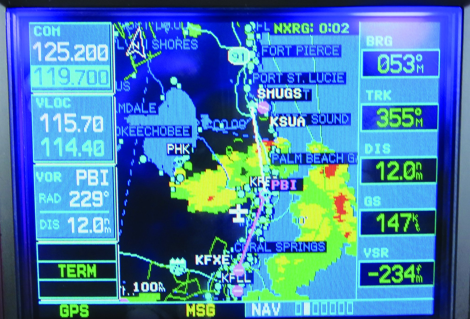
These days, it’s easy for forecasters to predict where we might find thunderstorms on any given day, at least in areas we’re likely to be flying. And thanks to modern tools like airborne Nexrad weather radar, it’s color-coded child’s play to identify storms. Once they’re identified, it should be a simple matter to remain clear of them. But apparently that’s too inconvenient for some pilots, who end up in a thunderstorm anyway, with predictable consequences. When dealing with storms, whether air-mass or frontal, avoidance is key. And there are two primary ways to think of avoidance: strategically and tactically.
Strategic Thinking
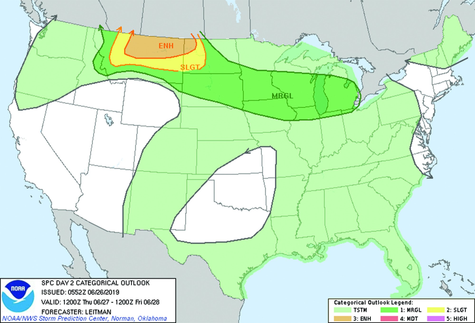
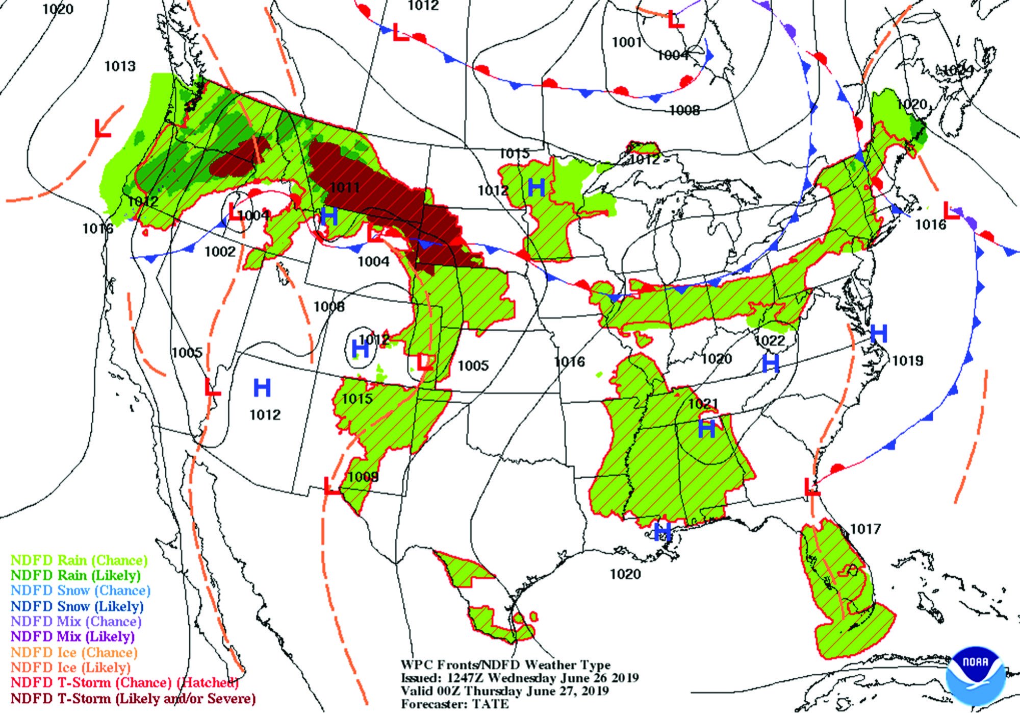
This type of thunderstorm avoidance begins a couple of days ahead of your planned flight. You’re looking at the prognostic charts, and the arrangement of fronts and precipitation areas. You’ll also want to look at the convective outlook and extended convective outlook. Two days out is too soon to be worried about ceiling and visibility details, or winds aloft, but it’s the perfect time to be thinking about what your strategic options are.
One of the strategic options you have is timing. Even if you have good reasons for wanting to arrive by a specific time, there’s rarely anything that says you can’t get there early. When using a personal airplane for travel, we’re always tempted to treat our transportation as something that’s just as reliable as the airlines. Nothing could be further from the truth, and it’s the wise pilot who builds into his or her schedule the flexibility to both accelerate plans and delay them as the weather dictates. Waiting for a fast-moving line of thunderstorms to pass over before launching in cooler, cleaner air is by far the smartest of your options.
In addition to timing, we also have route flexibility. If there’s convective weather between us and our destination, taking an admittedly longer route around it might add some time to our journey. But it might not, especially if we pay attention to the forecast winds and maneuver so we catch a tailwind in the bargain. In any event, it’s far better in our book to take a detour of an extra hour or so—the kind of worry-free flexibility smart scheduling allows—than to try finding a hole.
All of which is well and good, but sometimes stuff happens. A storm-spawning front is forecast to be affecting your destination at your ETA. Or the advancing front is solid yellow and red for hundreds of miles to either side and way too far to fly around. Even the RJs are staying away for a few hours. Maybe it’s a cluster of air-mass storms sitting over your departure point, and you’re not going anywhere until they move off. You still have options involving time and route. Primarily, those options involve getting or staying on the ground until the front passes or the storms dissipate.
Refining your strategies isn’t hard. For one thing, both air-mass and frontal storms are more numerous and stronger during the hottest parts of the day. An early-morning departure can get you at least most of the way to your destination in time for a leisurely lunch as the front blows through. Waiting until the afternoon storm clusters have dissipated, resulting in many more miles of clear air between them, is also an option, although it may push your ETA into darkness.
These strategies are obvious. They also should be automatic: When planning a summertime trip, schedule flights to avoid the worst heat of the day and take advantage of cooler morning temperatures. Instead of trying to cover all that distance in one or two hops, build in some fuel and leg-stretching stops along the way, allowing you to avoid the afternoon storms. It’s not rocket surgery, and there’s plenty of schedule flexibility if you do it right.
Making these decisions while sitting at home or in a hotel room is a lot easier and simpler than when confronting an airborne Nexrad display that looks like modern art.
Going Tactical
Maybe your destination is just up ahead. Maybe the line of storms between you and it isn’t completely solid and there are some gaps. Maybe you can see good VFR off to the south of your departure airport, but the route to the north looks ugly. You’ll likely get wet, but there’s a reasonably clear route you can take around or through some widely spaced storms. If you really want to stumble around in the rain like this, what tricks and techniques can you employ to get past this nuisance? This is when we need to shift from strategic thinking to considering the tactics we can use to complete the mission.
First, though, and as we’ve said before, the best way to stay out of a thunderstorm is to remain in visual conditions, even when operating IFR. Staying in the clear, of course, is no guarantee you won’t be affected by a storm if you’re closer than the FAA-approved 20 miles. There’s hail, there’s turbulence and there’s windshear, all of which can be encountered in severe-clear weather near a mature thunderstorm.
So it should be a no-brainer that we don’t want to fly close to or into a thunderstorm. For example, it’s always better to remain in clear weather and land somewhere to wait it out. But there are occasions when the air between adjacent storms presents visible moisture to the extent that there might be something in there and there might not. I think that’s the kind of situation a lot of pilots encounter when they conclude that poking their nose into a cumulus cloud system is a risk worth taking. The result is almost an old Ron White punchline: While we might not know how many survived, we do know how many didn’t.
In-cockpit Nexrad weather radar has helped transform the way many of us fly. But as the community had to learn the hard way, Nexrad is not a real-time presentation: The pictures it paints can be as much as 20 minutes old by the time you see them. In that 20 minutes, a lot can change with a storm—it can grow in diameter, it can grow more severe and it can grow taller. It also can move several miles, perhaps closing off that easy, 20-mile straight-in you’ve been planning for a couple of hours.
Nexrad is just another tool, like your Mk. I, Mod. I eyeball, to help you avoid storms. And just like your eyeball, it has well-known limitations. Don’t put all your eggs in the Nexrad basket.
Never, ever enter a cloud or area of reduced visibility near a thunderstorm without positively knowing what’s on the other side, and how far you have to go to get there. If there’s no blue sky very close by, don’t even think about it. This is a good time to point out that certain combinations of cloud color and natural light can resemble clear blue sky. They aren’t, and it isn’t.
But before you’re even tempted to see what’s on the other side of that visible moisture, you’ve already done your homework, right? You’ve been using your onboard Nexrad display, listening to ATC chatter and making a quick scan of nearby Metars to learn what’s underneath these storms. You compare all that data to what you can see out the windscreen to get as much of the big picture as you can.
For example, by the time you get close—50 miles or so—you should already know if there is a line of storms, a cluster or just one spanning a couple of counties. You also know if it’s moving, how fast and in what direction. If you also can display airborne traffic that far away and you’re in busy airspace, you might even notice the routes airliners are taking around, through or between the storms. That’s not an invitation to follow them, but at least you’ll know what they’re avoiding and where it is.
Another thing you’ll want to know is the winds at your altitude. The storms themselves are going to be driven by the prevailing winds, and have their own groundspeed. If we’re flying into the headwind driving the storms, we’re also limiting our maneuverability. With this in mind, a ragged line of storms, with plenty of clear air between them but moving at a good clip, might be best approached by paralleling it until you’ve passed the break in the weather you’ve selected. If all looks good, turn back downwind, accelerate in relation to the storms, and zip through the hole more quickly than with the headwind.

By this time you also know what impact, if any, there will be on your planned route. Is that fast-moving line of storms going to get to your destination before you can? Even if it probably won’t, are you sure you want to take on that challenge? Or maybe your destination presently is serving as ground zero for the mother of all thunderstorms. Where will you go? Don’t get yourself boxed in trying to get to your destination when heading off to a divert airport—whether you land there or not—is the smarter choice. What about having to go in the “back way,” a route you wouldn’t otherwise take but which will keep you in clear air all the way home?
In either of these last two situations, do you have enough gas? It’s another no-brainer: Having plenty of fuel aboard when you’re making these decisions buys you additional time to make the decision itself while opening up more alternate routes and divert airports.
A tactic you may hear about from time to time involves ducking under the storm bases into clear visual conditions and motoring off to your destination. A lot can go wrong in a hurry with such a plan. Success depends on the ceiling once you’re underneath the bases but it hinges on the terrain. And you’ll need to constantly update your situational awareness.
One mitigation might be to slow down, buying you more time to process everything. Another is to pick some potential divert airports—preferably with hangars and hotels—along the way and fly from one to the other to your destination, or to better weather. Trying to do all this IFR isn’t going to endear you to ATC, and giving up a clearance can be a big decision. If there’s a chance you’ll come back for a pop-up IFR clearance, don’t cancel. Don’t try ducking under unless the Metars in the area show the bases are high enough to keep you well above terrain; I’ve always wanted at least 2500 feet under me.
Finally, you don’t have to do this. It’s likely there’s an adequate airport a few miles over your shoulder, with fuel and food, where you can wait it out.
Putting it all together
Thunderstorm season doesn’t mean you have to park the airplane until the fall. But it does mean its utility can be limited. No matter what you’re flying or its capabilities, there’s no way to fly into a thunderstorm if you remain in visual conditions. If you can’t do that, consider turning around and landing at the nearest suitable airport to reorient.
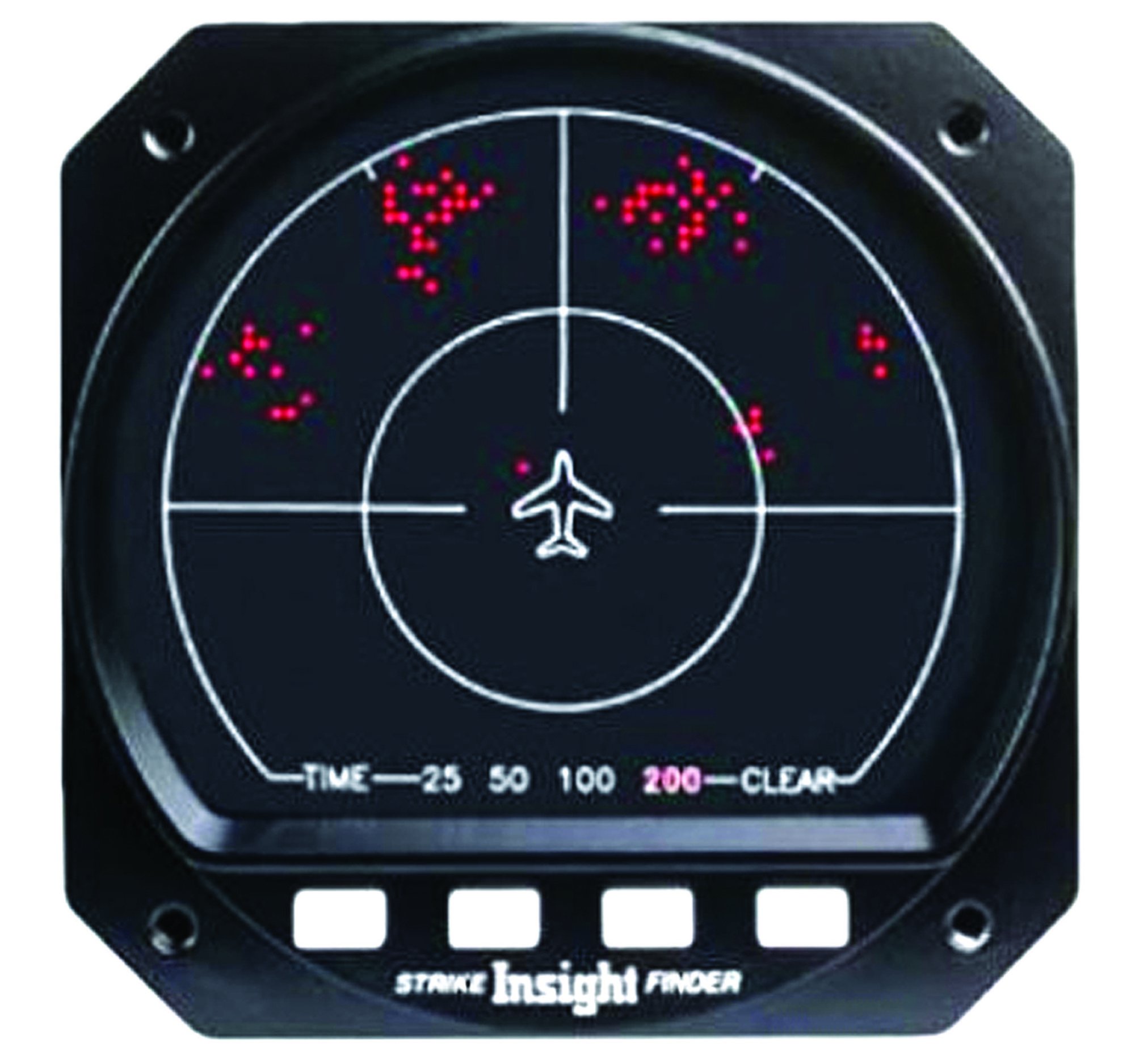
A lot of us are still flying around with sferic devices like the Insight Strike Finder or the Ryan/3M/BF Goodrich/L3 Stormscope line. In their day, they were another tool pilots of aircraft lacking weather radar could use, along with Center Weather Advisories and what weather the controller could see on his scope.
An sferic device helps a pilot determine the position of thunderstorms by locating their accompanying atmospherics, e.g., lightning and turbulence. They are inexpensive, at least when compared to radar, easy to operate and they reliably plot the azimuth of the phenomena they observe. Their distance accuracy isn’t the best, however, and neither is their resolution. They are relatively immune to attentuation, in which an airborne radar may mask weather behind a displayed return.
If you have in-cockpit Nexrad, you have better technology and information than is available with an sferic device alone, perhaps with lightning. But you may still want to hang onto an installed and working example since they do work as advertised.