
Environmental risks, one of the four broad hazard categories the FAA identifies in its PAVE acronym (see the sidebar at the bottom of the opposite page), typically involve weather and terrain, but also can include traffic, navaids, obstacles and even wake turbulence. When several such hazards are present at the same time, they can easily overwhelm a pilot and increase the risk level dramatically. Applying proper risk management techniques—before and during the flight—will almost always identify them. It is then up to the pilot to assess them and apply effective mitigations to lower the risk level. Sometimes, the only acceptable mitigation is to delay or cancel the flight, or divert to the nearest suitable airport.
It can be a tough decision to change or cancel plans when there are expectations to meet at the other end. And not meeting expectations is part of the decision-making process when you cancel. In fact, it’s a guaranteed outcome. Pushing on in the face of a challenging environment, on the other hand, may or may not have adverse consequences. That decision also has the benefit of meeting those expectations, even though possible outcomes include catastrophe.
One of the reasons accidents resulting from poor risk management of weather and terrain hazards are not easy to identify involves adoption of the CAST/CICTT (Commercial Aviation Safety Team/ICAO Common Taxonomy Team) classification system, which lacks granularity in some instances. For example, the Bonanza icing accident discussed in this article lists “fuel related” as a defining event. That’s the way CAST/CICTT classifies induction icing.
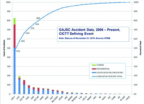
The chart at right, from the joint FAA/industry General Aviation Joint Steering Committee (GAJSC), shows that 72 percent of GA accidents occur from just four defining events: loss of control in-flight (LOC-I), controlled flight into terrain (CFIT), system component failure of the powerplant (SCF-PP) and fuel. While useful, this type of analysis doesn’t explain the “why” of the accident—did the pilot run out of fuel or ice up the induction system? When a more in-depth root cause analysis is performed, we often find poor risk management is the ultimate root cause of an accident.
GEOGRAPHY MATTERS
It’s important to acknowledge that multiple environmental factors often compound risk and can present a pilot with an overwhelming chain of events if proper techniques are not followed. For example, I live in the Northwest U.S. and frequently transit the Intermountain West in my Mooney 201 to locations throughout the United States.
The weather and terrain hazards generated by the Cascades and the Rocky Mountains figure prominently in my risk management planning. I often mitigate combined weather and terrain hazards and risks by actions such as departing early, sometimes days early, or taking a much more circuitous routing. In order to maximize reliability in trip planning, I begin preparations for these trips ten days in advance, as the rolling long-range weather forecast becomes available. Poor management of similar risks figured prominently in the fatal December 2013 crash of a turbocharged Beechcraft B36TC Bonanza in Idaho.
The Bonanza was on an IFR flight plan from Baker, Ore. (BKE) to Butte, Mon., (BTM), a distance of 234 nm. Although the private pilot was IFR-rated and qualified, the airplane was not approved for flight in known icing conditions. The forecast weather for this route was grim. Although it was VFR at Baker, under an overcast, the conditions along the route ensured that the Bonanza would be in cloud at its filed altitude of 13,000 feet. All of the FAA’s Airmets were in use: IFR conditions, mountain obscuration, moderate turbulence, low-level wind shear and moderate icing from the freezing level to 20,000 feet. The freezing level varied from the surface to 7000 feet msl.
The Bonanza’s pilot got airborne and picked up his IFR clearance at 1930 UTC. At 1956, the controller queried the pilot about his altitude. The pilot responded that he “was picking up too much ice,” and needed to divert to Salmon, Idaho, which was still ahead of him and even deeper into the mountains. The pilot requested a lower altitude, and the controller stated that 12,000 was the lowest he could descend to for terrain clearance. At 1301, the pilot stated he was having engine problems and had descended to 10,000 feet. One minute later he announced that he had lost his engine. The controller noted there was an airport nearby, but there was no further contact.
The Bonanza crashed into the Idaho wilderness, killing its pilot and his four passengers. The final NTSB report noted that the Bonanza’s engine induction system had an alternate air system that the pilot apparently did not activate. (The report labeled one of the accident’s defining events as “fuel related,” which this accident was anything but. See the sidebar above for why.)
This is an easy accident to process through our risk management lens. Let’s assume that a controlled or uncontrolled descent through clouds into harsh terrain would cause catastrophic consequences (i.e. fatalities and destruction of the aircraft). Given the weather and other conditions of this flight, we might also assume icing would be probable, or at least occasional. It’s not clear why the Bonanza pilot failed to identify, assess and mitigate the obvious risks he faced on this flight. What is clear is that these risks were readily identifiable and could have been mitigated by staying on the ground.
The FAA’s PAVE acronym is a method of organizing a structured approach to risk management, especially in pre-flight planning but also once airborne. It stands for the Pilot, the Aircraft, the EnVironment and External pressures. Weather and terrain are central to considering environmental hazards, but so are more common elements. Among these other considerations are the airports to be used, the airspace and the time of day, with an emphasis on nighttime illusions.
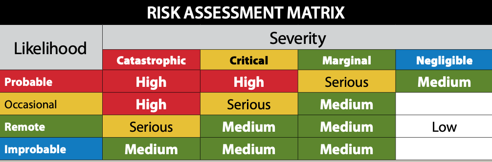
Once the hazards are identified, they must be assessed and using a risk assessment matrix like the one below is what the agency recommends. It’s important to note that a “hazard can be a real or perceived condition, event, or circumstance that a pilot encounters,” according to the Risk Management Handbook.
SCUD-RUNNING CIRRUS
In January 2005, a Cirrus SR22 came to grief while trying to thread its way through the Columbia River Gorge separating Washington and Oregon. The pilot and his two passengers were killed when the Cirrus collided with a heavily forested ridge at night. The Cirrus departed Salem, Ore. (SLE), at 1951 local and attempted to get flight following. Although ATC subsequently tracked the Cirrus, it could not be radar-identified when a flight-following request was made. The Cirrus was tracked as it entered the Columbia River Gorge and the last radar return showed it at 2500 feet. The airplane did not arrive at its destination, Ken Jernstedt Airfield, Hood River (4S2) and was reported missing the next morning.
The nighttime flight was conducted in marginal VFR conditions in the mountainous terrain of the Columbia River Gorge. A witness at Salem reported that in a conversation with the pilot, the pilot admitted to “scud running” numerous times flying to and from Hood River.
“Shooting the Gorge” is a time-honored tradition among some pilots in the Northwest and it can be safely done under certain conditions. However, doing at night in marginal VFR is not one of them. If we assess this flight against our risk matrix, we can easily see that the risk severity is “catastrophic,” and the likelihood of that occurrence is at least “occasional.” Hence, we would rate the risk as high, requiring mitigation. Given the circumstances of the flight, the only acceptable mitigation may have been to delay the flight until the next morning.
The NTSB listed the probable cause of this accident as “the pilot’s failure to maintain terrain clearance.” Yes, that was the final event in the accident chain, but the root cause of this accident was clearly poor risk management. It’s also interesting to note that the Cirrus Airframe Parachute System (CAPS) was not deployed by the pilot, indicating that he never saw the ridge that he plowed into. The CAPS system, unfortunately, cannot anticipate a pending crash (at least not yet). The pilot must take positive action to do that. See the sidebar above for a recent example.
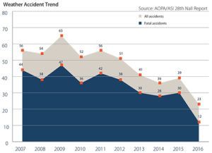
The Aircraft Owners and Pilots Association (AOPA), through its Air Safety Institute (ASI), also does a pretty thorough job of analyzing accidents. They publish their annual Nall Report on general aviation accidents and take a slightly different approach to accident analysis. For example, the two charts at right are adapted from the most recent Nall Report, the 28th, which analyzed accidents occurring in 2016.
As the chart at top presents, the good news is the trend line is headed down. It’s probably too soon to know for sure—correlation is not causation—but the downward trend coincides with increased availability of in-cockpit weather through the FAA’s ADS-B In data.

The bottom chart displays the results for weather accidents, which are particularly deadly, with the category “VFR into IMC” being fatal 50 percent or more of the time. Yet, even this tabulation still does not explain why the pilot ended up as a VFR-into-IMC statistic. I tackled the VFR-into-IMC accident problem in this journal in the January 2016 issue (“Continued VFR Into IMC”). In that analysis, I found that all the accidents I reviewed met my criteria for having a root cause of poor risk management.
A MOONEY CLOSE TO HOME
In February 2018, a Mooney M20K (231) collided with the slopes of Chuckanut Mountain, less than four miles from my nearby condo, killing the solo pilot. It was on a ferry flight to Bellingham, Wash. (BLI), for maintenance at the same shop servicing my Mooney M20J. It was night, but with good VFR conditions. The radar track shows it on a steady descent out of 4300 feet msl as it let down for Bellingham. The Mooney’s pilot contacted tower controllers about 14 miles south, but there was no further communication. This accident remains under investigation.
STAY ON THE GROUND?
All of these accidents I’ve described involved a combination of weather, terrain and/or night operational hazards. Describing them as CFIT accidents does everyone a severe injustice, since they all resulted from poor risk management.
The key to understanding these accidents is to understand the relationship of risk likelihood and risk severity. The risk associated with the hazards present in these accidents was readily identifiable. The risks boil down mostly to the consequences of a CFIT accident. In fact, even cursory pre-flight planning would have detected them. An unanswered question is why these pilots thought these flights were reasonable to undertake.
When assessing environmental risks, the severity level is pretty well fixed at catastrophic, i.e., loss of life and/or the aircraft. The only mitigation in these circumstances is to reduce the likelihood of the event occurring. For example, you can delay or speed up your departure time or date, or perhaps take a different route.
Sometimes, however, the best decision is to cancel the flight. Therefore, you should always begin planning a transportation flight days ahead of the desired departure day. That way, you make alternate travel arrangements if you absolutely have to be somewhere or return home at a fixed time.
Robert Wright is a former FAA executive and President of Wright Aviation Solutions LLC. He is also a 10,000-plus-hour ATP with four jet type ratings, and holds a Flight Instructor Certificate. His opinions in this article do not necessarily represent those of clients or other organizations that he represents.
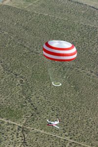
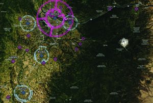
On January 27, 2020, a Cirrus SR22T descended under its airframe parachute onto a Colorado mountainside four minutes after departing the Aspen, Colo., airport (KASE). Weather at ASE was 900 overcast, with three miles of visibility and a temperature of -2 C. Snow had just ended. Miraculously, the two occupants were uninjured, although they were trapped in the remnants of their Cirrus, hanging from a tree on a mountainside until they were rescued.
I hate to speculate on this accident, since it is so recent it is only covered by an NTSB preliminary report; there has been no probable cause determination yet. However, consider the environment when they departed. It was IFR, below freezing, surrounded by mountains, and they were in a single-engine piston. Even with turbocharging, and even if it was approved for known icing—it better have been—this aircraft was not designed for this kind of environment. Here is an image of the terrain around the ASE airport and accident site.
Did the pilot perform a risk analysis before the flight? If he had, he would surely have concluded that an encounter with ice was possible, and if it became severe right away, there was no place nearby to make a quick retreat to. Did he slough this off because, well, there’s always the ‘chute?
Both Cirrus Aircraft and the Cirrus Owners and Pilots Association (COPA) have made commendable efforts to lower the Cirrus fleet’s initial fatal accident rate, and that effort has been successful. For example, COPA has developed a critical decision-making (CDM) course that embraces the principles of risk management. I wonder if the pilot of the Aspen Cirrus completed that course.


