
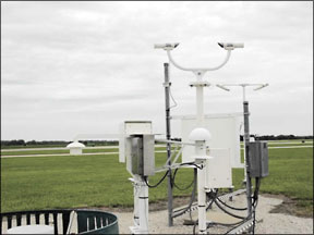
When you get right down to it-the ground, that is-precise knowledge of local weather is the single critical factor determining whether your three-hour instrument flight is going to have a happy ending. Youll either get an easy peek at your flight-storys last page or itll become a cliffhanger at decision height, followed by a missed approach. Naturally, weather has a significant effect on the critical few minutes of an instrument approach (even a VFR approach), as well as our decision-making process. 288 Back in the “good old days,” weather observing and reporting was the province of well-trained humans with substantial local knowledge. They knew, for instance, precisely how far away prominent landmarks were, the effects of an evening breeze across the lake adjacent to the airport and reliably reported cloud height and type. But they kept wanting more money and things like health and retirement benefits. Plus, they didnt like pulling the midnight shift, when only a handful of airplanes used the airport. Thus began the era of automated weather observations, for better or worse. Real-World Experience I was coming into the General Edward Lawrence Logan International Airport (Can they make this airports name any longer?) at Boston, Mass. (BOS), on the ILS Runway 4R approach. The ATIS was reporting 300 scattered, 3800 broken and good visibility. I was on a medical flight for AirLifeLine (now part of Angel Flight), bringing a burn patient into Signature for pickup and transport to the Shriners burn unit. We were already late because Id had to wait two hours for below-minimums weather to lift that morning, before I could get into Manassas, Va., to pick up the patient. The tower at BOS made the oft-heard request for a “good rate” on final and there were airliners in a conga line right behind us. I was flying a Cherokee in visual conditions, and with 300 scattered, I wasnt too worried about getting behind the airplane at 130 knots, so thats what I gave him. Id been monitoring the ATIS since before it had gone from “Kilo” to “Lima” and things were looking good. The grunt of appreciation I got back on the radio felt good, like hed patted me on the back. After Id intercepted the glideslope, though, I looked ahead and all I could see was a carpet of white. Something was wrong. And it stayed wrong. At 200 feet, I was still inside a milk bottle, and went around. I made a point of telling the controller, in effect, “Look, I dont know where your ATIS observation is being made, but out here theres sure as heck no 300 scattered.” The controller wasnt happy with me, and it wasnt because of my non-standard phraseology. However, after the next two airliners also missed the approach, I imagine that he was much less annoyed. (We did make it in on a subsequent approach.) Why was a very recent ATIS reporting one thing, while pilots like me were encountering something else? AWOS/ASOS Limitations The weather observations at BOS-and most other airports, large and small-are taken with automated equipment. In the case of BOS, its the latest and greatest, an ASOS, or Automated Surface Observing System. Its the successor to the Automated Weather Observing System, AWOS, which nowadays is found at smaller facilities. The major differences are summarized above. Two large studies done several years ago found agreement between human and automated observations was fairly uniform in VMC, but the disparity does go up in MVFR and IFR weather. Interestingly, the more recent study-done in 1997-found automated systems reported ceilings below 200 feet and visibility under a half mile about 50 percent more often than did human observers. It also found ASOS visibility differences were pronounced whenever visibility was six miles or less, or when there was showery precipitation. This isnt too startling considering that the automated reading comes from a 10-minute average inside less than a cubic meter of air at one fixed point. Wind speed and direction, temperature and altimeter information almost always work great. We get slightly lower minimums, and advance notice for important factors affecting what runway to use and what kind of performance we can expect. 288 But the inherent difference between a human observer and an automated system rears its ugly head when it comes to ceiling and visibility, especially when your destinations weather is changing. Automated systems use a “fixed location, time averaged” value, and human observers of course will always “eyeball it” with the “fixed time, spatial averaging” method. For example, the AWOS/ASOS ceilometer looks at the sky from one location near the touchdown zone during “detection cycles” that can each be as brief as 12 seconds (during which thousands of pulses are sent) and averages these over 30 minutes, with a double-weighted average over the last 10. Okay, fine. So you basically get a “downwind,” “after-the-fact” report of sky conditions. Thats what Id gotten that day at BOS. Of course, there could very well have been 300 scattered at the touchdown zone, but with a three-degree glideslope, the touchdown zone is over 3800 feet away from where you are at decision height. Thats more than enough room for convective weather, the proverbial “hole in the clouds,” or a fog bank to pull the rug out from under you. This last one is particularly critical for you to remember if youre flying into an airport near the water, like Boston. As it turns out, at Logan they have several ceilometers around the field (a wise option when an airport is near a large body of water), as well as a full-time human to supplement the ASOS readings (which we hear as an ATIS). The problem was the observer was in Logans old “Terminal A,” which was (as I was told by a controller who was there at the time) in the clouds, anyway. Are you beginning to get the flick? Micrometeorology I learned another lesson in micrometeorology right at a local airport in Gaithersburg, Md. My plan was to do something I hadnt done in many months: actually file a VFR flight plan. All I wanted to do that morning was pattern work. I hadnt flown a Cherokee in awhile and I thought this would be a good way to get reacquainted. It was another sultry mid-Atlantic summer morning. I telephoned the local AFSS to get a standard VFR briefing an hour earlier; the briefer noted some areas of low-lying fog but said it was forecast to burn off by 1000 local. As I approached the airport, I could see the haze had gotten thicker. When I arrived, the AWOS was reporting light easterly winds, no clouds below “one two thousand” and three miles visibility. Before I was even over the departure end of the 4200-foot runway, I could see low clouds covering the entire departure path. As I gained altitude, I could see the clouds were more broken than scattered. As I turned onto the crosswind leg and looked downwind, however, I saw my approach path had a similar appearance. If youre guessing that I felt like a sucker up there, youd be right. I decided one thing right then: Once I get down, Im done flying for the day. It wasnt overcast, the winds werent calm, and the clouds were slowly moving. I had five hours of fuel and doing nothing is always a good first step when assessing your options in a situation where everything else is otherwise under control. So thats what I did. I flew around the pattern for a few minutes and saw the clouds moving away from the other end of the runway. I flew out, did a teardrop from my upwind leg and saw I wouldnt need a lawn-dart approach to make it back in this time. The landing was, as they say, uneventful. So what did I (re)learn from this? For one thing, an AWOS looks straight up, from one location on the ground. Id known that. But because of the haze-and, incidentally, a layer of high cirrus above-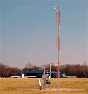
On the ground, I called clearance delivery to cancel my flight plan, taxied back in to the roost, called flight service back with a Pirep from on what Id seen, buttoned up the airplane, drove home and on my way, bought my wife a dozen roses.
The Big Picture
What we can do about this? It starts with being prepared, of course; study up on your destination and approach procedures beforehand. Be more aware of local limitations and discontinuities. Helping other pilots by notifying FSS and ATC when the reported/forecast weather differs from what youre encountering.
We can gather a better “big picture” ourselves, by listening to area Hiwas broadcasts and getting updates from the En Route Flight Advisory Service. If youre VFR-only, learn about the options available with Special VFR.
Also, we can remember the inherent limitations of all such time-averaged algorithms, since it can take several minutes for any sudden change in ceiling or visibility occurring during the last 10 minutes to even show up. So whenever things are changing, or marginal, or worse, listen for at least 10 minutes. Of course, its always a good idea to listen to the ATIS/AWOS/ASOS from as far out as you can.
Also, whenever its bright enough to make you reach for the sunglasses but hazy, halve the visibility report, because the machine is using the more efficient “forward scatter” to basically look into its own headlights, whereas our eyes only see half as far through the murk by backscatter, which is much less penetrating. If the weather is in doubt, asking ATC if anyone “went missed” may help warn you in advance if ceilings and/or visibilities are lower than reported. Last but not least, follow standard procedures regarding when you can land and when you shouldnt, and always be prepared to go around.
Do automated systems “lie?” Not really, but they do have their limitations. Understanding how they work, from where they work and what they cant do will help eliminate the kind of surprises I discovered that morning at BOS.
Jeff Pardo is a freelance writer and editor who holds a Commercial certificate for airplanes, helicopters and sailplanes.


