
As long as you’re not worried about engine failure, the safest altitude is one that keeps you absolutely clear of terrain. The FAA has created a whole suite of acronyms to do this: Minimum sector altitude (MSA), minimum obstacle clearance altitude (MOCA), offroute obstacle clearance altitude (OROCA) are some examples. These acronyms and the numbers that go with them are designed to keep you above the rocks.
288
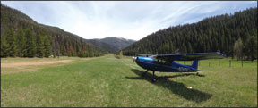
At some point, however, you have to land and for many airports you have no choice but to maneuver among the hills, rocks and trees before touching down. While exercising your ticket, you may find yourself flying below the level of the surrounding terrain. If you are like me, that first experience is disconcerting. But I learned lots from it and subsequent experiences.
First Exposure
I learned to fly in Kansas in 1982. According to the Annals of Improbable Research, Kansas is flatter than a pancake. I suppose there are some river valleys, gullies and badlands in some parts of the state with tens of feet of relief, but in Kansas, it is difficult to find yourself significantly lower than the terrain.
After college in Kansas, I moved to Colorado and, in 1991, to Idaho. Both of these states posses terrain and its corollary—topographical relief—in great abundance. So much so, in fact, you are almost always below nearby terrain because airports tend to be located in valleys. When I began flying again after a 20-year respite, one of the most difficult things to get accustomed to was the omnipresence of terrain in my adopted state. After completing my bi-decade flight review, I booked a rental plane for my first solo flight in Idaho. I had no particular destination; I just wanted to experience the freedom of flying the way I had in Kansas. I took off and climbed over the city to a few thousand feet agl and leveled off. It felt good. I closed the cowl flaps, trimmed the plane and smiled as it accelerated to 120 KIAS. On a whim, I pointed the plane east. I wasn’t ready for what happened next. The ground began rising. I was holding altitude, but the ground was rising because I was heading toward higher terrain. It was the first time it dawned on me that I wasn’t in Kansas anymore.
The Idaho Falls, Idaho, airport where I base is located in a flat river plain at 4740 feet msl. The Bone Hills to the east of the city gently rise to about 6200 feet over 10 nm. They are so gentle, they barely deserve the moniker of hills, but heading east at 7500 feet msl at 120 knots, they will rise toward the aircraft at 300 feet per minute. In 10 miles, I was almost back at pattern altitude (agl) while in level flight. I found this experience jarringly disconcerting.
I recognized that as a Kansas pilot, I was way out of my element and I needed more training, not in how to fly the airplane but how to fly in a place where the landscape beneath it has actual features. All the books, magazine articles and tribal wisdom told me a mountain flying course was what I needed. Mountain flying is a bigger subject that covers a wide variety of topics like mountain weather, density altitude, canyon flying, short fields and slow-flight techniques. One of the practical things that comes with mountain flying training is an understanding of maneuvering below terrain.
Becoming Terrain-Aware Every sectional chart is broken down into 30-nm by 30-nm quadrangles containing a bold blue number with a smaller superscript. This number is the maximum elevation figure (MEF) for the highest known obstacle or terrain (with some added fudge factors) in that quadrangle, represented in thousands (the big numeral) and hundreds (the superscripted numeral) of feet. The sidebar at right provides some additional details on MEFs and how you might use them.
At the Miami County Airport (K81), my home facility in Kansas, the MEF is 22 surrounded by 22, 20, and 17 to the south. With the exception of the Appalachian mountains, this is pretty typical for most of the U.S. east of 100 degrees longitude, where sectional charts are dominated by pastel greens reflecting terrain below 3000 feet.
As a rule of thumb, if the sectional is dominated by green, MEFs likely reflect the tallest tower in the area. If the sectional has shades of tan or brown—as it does for most of the western U.S.—the MEF likely reflects topographic high points rather than manmade objects like towers. If the sectional you’re using is predominantly brown and you’re cruising at an altitude lower than the MEF, you’re probably flying below terrain.
With that refresher out of the way, let’s talk about different ways we can find ourselves below surrounding terrain. By my reckoning, there are five main categories of flying below terrain, each requiring its own particular situational/terrain awareness:
• In the valley;
• Near the big one;
• Over the pass;
• Among the peaks; and
• In the canyon.
Let’s look at each of them, and how they’re different.
In The Valley The obvious routes in mountainous terrain follow equally obvious valleys. Valley routes often follow rivers and have highways, cities and lights, making them easier to find and follow when flying VFR. When ceilings drop, the mountains can be obscured, but the valleys commonly remain open and safe. By definition, valleys are low places surrounded by higher terrain. The key to valley flying is always knowing where you are with respect to the sides of the valley and staying between those sides.
It’s also good to know where there might be constrictions, which can create a venturi effect, funneling traffic and winds. It’s also good to know where the wide spots are that will give you breathing room for a spiraling climb out of the valley.
In bad weather, you can expect lower ceilings next to valley walls where orographic effects induce cloud formation. Don’t believe the TAF for the airport on the valley floor—ceilings along the valley edges will be much lower.
You may only be in the valley during your descent into or climb out of an airport. If your plan is to climb out of a valley, know the direction, height and orientation of the valley walls. You may find your planned straight-line climb-out path looks great on paper until you do the math and discover that, at 10 nm out at 500 fpm, you have climbed only 5000 feet while the valley wall has climbed 8000. This is less of a factor on descent, but don’t be surprised if you’re getting terrain warnings on descent because the valley wall behind you is now within 500-1000 feet of your current altitude.
Near The Big One
There are a lot of places in the U.S. with prominent peaks or isolated ranges rising starkly above the surrounding landscape. Northern Arizona has the San Francisco Peaks near Flagstaff. The Cascade Mountains have Mount Rainier and Mt. Shasta, and many other hopefully dormant volcanoes. What do these places have in common? Many of them have airplane wreckage somewhere near the top.
By day, in VFR conditions, these prominent peaks dominate the horizon, making them pretty hard to hit. As the sun sets or as clouds settle in and ceilings drop, they become booby traps for controlled flight into terrain. Big ones don’t have to be that big, they just need to be higher than your aircraft’s current altitude. All it takes is one peak jutting into the flight path to ruin your day.
To avoid hitting the big one, you need to be aware it exists and maintain good situational awareness of where it is with respect to your planned course and aircraft performance, and be prepared to give it proper respect by day. It should receive even more respect at night or in tough conditions like low-angle sun in your eyes, a cloud deck obscuring your view or high density altitude affecting your climb performance. If your altitude is below the big one, you need to know exactly where the plane and obstacle are in relation to each other. If you don’t, your aircraft will become an obstacle detection device, good for one use.
Over The Pass
Frequently, your main terrain obstacle is a high ridge that must be cleared. The safest way to cross any ridge is to climb well above it, but that’s not always practical or necessary. Mountain passes have long been used by land lubbers and they have offer similar utility to pilots flying below terrain. Ridges have shady sides and sunny sides, windward sides and leeward sides. The combination of these factors, season, weather conditions and the time of day will determine things like updrafts and downdrafts, ridge lift and rotors.
Conditions often drastically change right at or just before the pass. Be aware that mountain passes can act as spillways channeling flow from one basin to another. It isn’t uncommon for altimeter settings to be drastically different on either side of a pass. During the transition through one, you may experience the convergence of conditions that may make you change your mind about the importance of being on the other side.
The standard procedure for crossing a pass is to approach with caution at an angle that will allow you to turn back at a shallow angle rather than a full 180-degree heading change. As you come up to the pass, you can assess your options. You will eventually see the valley on the other side. When crossing a pass, it isn’t “made” until an engine-out glide will get you safely to the other side. Keep in mind also that passes can act as venturis that will accentuate the effects of wind conditions. If you have a headwind approaching the pass, expect it to increase as the gap narrows.
Among The Peaks
Flying among the peaks is similar to looking out for the big one, there are just more big ones jutting up into the two-dimensional plane of your cruising altitude. Even in seemingly random jumbling of peaks and high points, there will be geographic and terrain patterns to be aware of. Peaks and obstacles clustered along high ridges present the main hazard while valleys represent your escape routes.
As you cross complex mountain terrain, be aware of which drainages you are passing over and which ones lead to safety, population centers, river valleys or highways. Some drainages take you toward civilization, while others can take you further into the wilderness. It is up to you to remain aware of the difference.
In the Canyon For me, the most invigorating flying below terrain is flying in canyons. I define a canyon as terrain that is deeper than it is wide, has cliff-like walls or is sufficiently narrow to make a 180-degree turn in your aircraft a thoughtful, challenging or even an impossible course of action, depending on your speed and turning radius. Importantly, canyons can be found anywhere, even in urban areas, where they’re comprised of man-made objects like buildings or airspace.
The two biggest issues in canyon flying are turning radius (which is a factor of your speed) and the interplay of canyon orientation with sun and shade. You don’t want to depart from a shady canyon strip into the bright sunlight without this understanding. When you turn the corner or lift from the shadows into the sunlight, you could be blinded. Not a good thing when you are below terrain, pinned between the walls, with cliffs on both sides. If your windshield is dirty or crazed, all bets are off.
In canyons, it’s also a good idea to ditch the tech. It is far more important to have your eyes outside the cockpit than it is to have your synthetic vision working or your iPad giving you a moving map. In narrow canyons, GPS is not your friend. Gadgets kill. Apart from causing visual challenges, the interplay of sun and shade can create interesting patterns of updraft and downdraft as well. Air over rivers is commonly sinking, while the sunny side of the canyon can offer a source of lift.
Embracing the change Controlled flight into terrain (CFIT) is generally fatal and, according to the FAA, CFIT accidents comprise 17 percent of all general aviation fatalities. Awareness is the key to avoiding fatal terrain encounters. You don’t need to fear being below terrain; you simply need to have ample respect and awareness. After spending some time getting trained, I no longer fear terrain like a flatlander, I embrace and seek out airstrips embedded in the mountains and have added backcountry flying to my routine. Even if you don’t plan on flying backcountry, understanding the tricks and challenges of flying below terrain will keep you from encountering it the hard way.


