
Time-lapse thunderstorm videos recorded by the International Space Station always remind me of science fiction movies, slightly unbelievable. The truth is both stranger and more violent than you may realize.
Our planet experiences constant thunderstorms, weather phenomena when solar heat stored in warm, moist air is converted into kinetic and electromagnetic energy, including X-ray and gamma-ray flashes. According to NOAA estimates, there are about 16 million thunderstorms worldwide each year, and roughly 2000 at any given moment.
In the U.S., about 100,000 thunderstorms occur annually. Only 10 percent fall into the severe category, but all of them are violent. An average thunderstorm releases about 10,000,000 kilowatt-hours of energy, roughly equivalent to a 20-kiloton nuclear bomb. A large thunderstorm, orders of magnitude greater, releases energy in the megaton range.
A safety-conscious pilot just needs to follow the FAA recommendation to stay 20 miles clear of these bad boys, right? Heh. Easier said than done. (See the sidebar on page 18 for more on the FAA’s recommendation.)
20 Miles From What, Exactly?
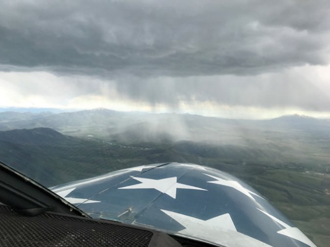
The 20-mile clearance policy is a safe number and probably easy to stipulate, but scale and definitions make it challenging. For every fully visible and developed severe thunderstorm, there are even more smaller cells or building storms that may or may not grow to thunderstorm level. Sometimes a curtain of rain is just a curtain of rain. Other times, it can be hiding something much bigger due to the lurking cumulonimbus that has built up above the overcast.
In 1964, U.S. Supreme Court Justice Potter Stewart famously described his threshold test for obscenity: “I know it when I see it.” While it’s one of the best-known phrases surrounding the Court, Stewart’s test doesn’t offer much clarity. Thunderstorms are similar. You should know one when you see it. And yet, we need to remain 20 miles clear of what exactly? Is it where a cumulus buildup starts to shower? When you see bands of heavy precipitation? Is lightning the point of demarcation?
Can’t be a thunderstorm without thunder, right? Is a single lightning strike on a weather radar or strike finder all it takes or do you need to see multiple strikes to call it a thunderstorm? When there is no lightning, but intense rain, should you stay 20 miles clear of the red or purple center of intense precipitation, or the outer band of yellow depicted on radar? Perhaps 20 miles from the nearest defined edge of a cumulonimbus cloud?
If you are asking any of these questions, your default should be to stay a full 20 miles clear of anything that matches any of these criteria. The right answer may be all of these or some combination. In short, the answer is, “It depends.” The praxis of staying 20 miles clear is more art than science, but if you think something is suspect, getting closer than 20 miles is like tickling a dragon.
In many ways, the FAA is being helpful by not telling us or regulating the precise definition of what we need to stay clear of. There are just too many variations of what makes a convective cell a thunderstorm. The more you fly in unstable weather, the more your senses will be attuned to what is an active thunderstorm cell and what is just rain—or perhaps a building system that isn’t a thunderstorm yet but will be in another hour. If you are a more experienced pilot and see something ominous advancing on an airport, do your compadres a solid and provide a Pirep, either through official channels or to the folks in the pattern.
Thunderstorm Gotchas
Thunderstorm-related accidents usually occur when pilots are trapped by their own faulty risk management, or when they are fooled by their ground experience. They see a storm coming and think they have time to get off the ground and out of the way before it arrives. Or they determine they can arrive at the airport ahead the storm, but then attempt to land right as a gust front hits. Either scenario can end poorly.
As I was flying into Logan, Utah, recently at 8500 feet, a cell 20 miles to the west was creating storm outwash with 50-knot winds from 270. The airport 10 miles from the cell was still reporting relatively light winds straight down Runway 17. Given the distance I had to close, it was a given I would experience windshear and I warned the pilots in the pattern it was coming. As I got closer to the airport, I passed the shear zone to the other side of the gust front. I landed with a calm wind, but five minutes later the gust front from the storm shifted and became a 35-knot, 90-degree crosswind.
Gust Fronts
An oncoming storm may seem to be distant enough for safety, but the strong gusty winds associated with them—gust fronts—often precede the mass of clouds and precipitation. Pilots not only have to cope with these winds, but because they are associated with a front, the wind direction shifts as the gust front passes. This, by definition, creates an area of wind shear, one of the more dangerous phenomena you can encounter near the surface.
At risk of sounding hyperbolic, if you are thinking about beating a gust front, be prepared to be in the jaws of one of the nastier surprises a thunderstorm can deliver. Attempting to take off into a gust front risks starting your ground roll with a strong headwind that becomes a tailwind right when you reach liftoff speed. The result will be a non-recoverable low-altitude stall.
Encountering a gust front on landing is equally bad. Your headwind or crosswind above the runway can become a tailwind in the flare or perhaps higher, resulting in a stall prior to touchdown.
I recently experienced a storm-related wind shear event while landing at the Salt Lake City International Airport. Fortunately, the Beech 99 ahead of me reported a 15-knot wind shear in the flare, so I was able to adjust my landing speed accordingly. Sure enough, right in the flare, the strong crosswind became a strong quartering tailwind.
Virga
When the gust front passes and surface winds finally pick a direction, you aren’t necessarily clear to come or go. As storms mature and the updrafts (that created the storm due to rising columns of warm moist air) start to weaken, downdrafts of cooler air gather strength and condensation begins to fall. These columns or curtains of descending rain are frequently called out by controllers and ASOS recordings as virga.
The thing to remember about rain is that it carries a bit of entrained air in the boundary layer, which induces downdrafts. Additionally, falling rain has mass which produces downward forces as well. The distinction between the two is that rain falling through cooler air isn’t likely to evaporate, so it will not have the additional punch from evaporative cooling. Still, expect downdrafts if you are passing through curtains of rain and, when you get to the other side, expect an updraft or upward wind shear from the updraft that created the storm or the absence of the downdraft relinquishing its grip on your airframe.
Flying through the curtains of rain under early-developing cumulus clouds can be okay, but there often is a point at which cumulus clouds mature into cumulonimbus cells, which you absolutely need to stay 20 miles away from.
Microbursts
Microbursts are a very specific form of storm downdraft. According to the National Weather Service, it is a localized column of sinking air within a thunderstorm and is usually less than or equal to 2.5 miles in diameter. They can be wet or dry, depending on the nature of the storm creating them.
To reiterate, as storms mature, the lifting forces carry vapor upward where it condenses into water droplets, adding more heat and more lift. This lifting energy carries water to flight levels where it can freeze into hail stones that continue to be carried upward. The act of freezing also gives off heat.
Eventually, when the lifting energy can no longer support the mass of liquid and frozen water, the process spontaneously fails, and the entire mass of air and water that was going up starts heading down. Microbursts are a phenomenon where it happens at the same time.
I have not directly experienced a microburst, and if I maintain a distance of 20 miles from the dragon, I should be able to keep that record. But I have seen round plumes of dust exploding upward from the ground, roiling away from virga. They are impressive enough at a distance that I never want to encounter them directly.
Outflow Winds
When a maturing storms starts to collapse and downdrafts take over, winds push down and outward from the center cells. Pilots should also beware of these winds, but they become less and less of a factor as a storm cell’s size diminishes. I have encountered outwash winds from building cells, stationary cells and ahead of moving systems, where they can be even more pronounced. Gust fronts, downdrafts from virga and microbursts are also essentially forms of thunderstorm outflow.
20 Miles Or Bust
Tangling with thunderstorms has a predictable outcome. Get too close and you risk getting smacked down, hard. There is a point, somewhere between a leaking early cumulus buildup and a dissipating cumulonimbus where the term thunderstorm no longer applies, With experience and a healthy thirst for the latest weather info, you will learn to “know it when you see it.” Until then, 20 miles of discretion is the better part of valor.
The Physics Of Thunderstorms
Pilots know that dry air adiabatically cools as it expands with altitude at a rate of three degrees C per thousand feet. Moist air, containing water vapor, retains its heat and releases it that vapor condenses, usually into cumulus clouds. The heat of condensation—a corollary to evaporative cooling—adds heat energy that warms the air so it continues to rise, creating more lift, which results in more cooling and condensation. This is the feedback loop that starts the engine of a thunderstorm energy release.
For a cumulus cloud to develop vertically into a true thunderstorm, it must also have an unstable atmosphere. Basically this means the lapse rate for a parcel of moist air will continue rising and will remain warmer and more buoyant than surrounding air, even as it expands and cools with altitude. When cumulus buildup lacks a stabilizing lapse rate above it, cumulus clouds grow vertically and turn into a cumulonimbus cloud—the ones we are supposed to stay away from.
Six hundred calories of heat are released for every gram of water condensed. If water freezes in the form of hail, you can add another 80 calories of heat released. This energy increases the temperature and therefore the velocity of storm updrafts, converting heat energy into kinetic energy.
This thermodynamic cycle—lift, condensation, heat from condensation creating buoyancy and more lift—just keeps going until all hell breaks loose in a violent atmospheric megastructure that generates lightning, hail and sometimes tornadoes. It doesn’t matter whether you are in a 152, DC-3, 737, F-35 or the Millenium Falcon, anyone with the sense of a live chicken knows better than to willingly fly through the guts of a cumulonimbus.
20 Miles From A Thunderstorm? Where’s It Say That?
In many circles, the FAA’s recommendation to avoid thunderstorms by 20 miles is taken as gospel. With other pilots, perhaps not so much. What actually does the FAA recommend, and where? The where part is easy: It’s in Advisory Circular AC 00-24C, simply titled “Thunderstorms.” The most recent revision is dated February 19, 2013.
The 13-page AC provides an overview of how thunderstorms develop and the hazards to aviation they pose. Those can include tornadoes, turbulence, icing, hail, lightning and engine water ingestion, which has been known to cause turbine engine flameouts. (The crash of Southern Airways Flight 242, a DC-9 whose crew made a deadstick landing on a road in Paulding County, Ga., on April 4, 1977, was attributed to the “total and unique loss of thrust from both engines while the aircraft was penetrating an area of severe thunderstorms.”) The AC also provides guidance on using the returns from airborne and ground-based weather radar (Nexrad).
The 20-mile recommendation is found in a discussion of turbulence, noting it can be encountered “up to 20 miles laterally from a severe storm. Additionally, clear air turbulence may be encountered 20 or more miles from the anvil cloud edge.” The AC also cautions that hail “may extend to as much as 20 miles from the echo edge.”
But the oft-quoted admonition to stay 20 miles away from a thunderstorm comes from a discussion in the AC regarding use of airborne weather radar: “Avoid heavy or extreme level echoes by at least 20 miles (i.e., such echoes should be separated by at least 40 miles before flying between them). Pilots may reduce the distance for avoiding weaker echoes.” (emphasis added)
Type Specificity
Clearly the specific technique you’ll use to fly a high-speed approach will vary greatly depending on the specific type of aircraft your fly. In some cases even the same airplane will have different “numbers” for a high speed approach at different ends of its weight and center of gravity envelop spectra. Agreeing to keep your speed up is not something you should do unless you’ve practiced a technique for doing so beforehand. You shouldn’t be making it up as you go the first time you fly a high-speed approach for real.
Mike Hart flies his Piper J3 Cub and Cessna 180 when he’s not schlepping people and packages for a Part 135 operator based in Idaho. He’s also the Idaho State Liaison for the Recreational Aviation Foundation.


Hi! I would suggest Aviation Safety team to upload short videos of 10 – 15 minutes duration on various aviation issues. Probably tutorials e.g. Thunderstorms, CRM etc..